Maps of Baden-Württemberg

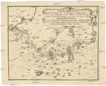
Veritable repraesentation des fortresses de consequence comme, elles se trouvent actuellement sur Rhein divisées et augmentées pendant la guerre avec plusieurs autres endroits
Německo jihozápadní
Grossherzogthum Baden
1 : 824000 Bádensko (Německo) Martin Gleditsch
Grand theatre de la guerre, frontieres de France, d'Allemagne.
L'Isle, Guillaume de, 1675-1726
Composite: Rhin.
1 : 256000 L'Isle, Guillaume de, 1675-1726
Tabula Nova Particularis Provincie Rheni Superioris [Karte], in: Claudii Ptolemei viri Alexandrini mathematice discipline philosophi doctissimi geographie opus [...], S. 278.
1 Karte aus Atlas Waldseemüller, Martin [und Ptolemaeus, Claudius] Übelin, Georg
Charte über das Grossherzogthum Baden
1 Karte : Kupferdruck ; 61 x 38 cm Tulla; Müller; Hutter verlegt bei C. F. Müller Hofbuchdrucker
Baden.
1 : 870000 Andree, Richard
Abriss des Reinstroms
1 : 870000 Mollova mapová sbírka
Baden.
1 : 870000 Andree, Richard; Times (London, England)
Charte über das Grossherzogtum Baden / entworfen und revidirt von J.G. Tulla ; die Reduction und Zeichnung von Nachbarstaaten von Krauth ; F.X. Hutter sc.
1 : 500000 Tulla, J. G.; Krauth, ...; Hutter, F. X. Carlsruhe : C.F. Müller
Geognostische Karte von Württemberg, Baden und Hohenzollern
1 : 700000 Bach, Carl Philipp Heinrich Verlag der G. Ebner'schen Kunsthandlung
Charte von dem Königreiche Wirtemberg und dem Grossherzogthume Baaden

Gross Herzogthum Baden
Grosser Hand-Atlas über alle Theile der Erde in 170 Karten Meyer, J. Verlag des Bibliographischen Instituts
Teatre De La Guerre sur le Rhein, Moessele, Mayn, &c le Necker [Karte], in: Atlas nouveau, contenant toutes les parties du monde [...], Bd. 1, S. 229.
1 Karte aus Atlas Sanson, Nicolas Jaillot, Alexis Hubert und Mortier, Pieter
Charte geographique de la campagne de haut Rhin pour l'année 1734 contenant tous les mouvements marches et contremarches des armées imperiales et Francoises
Breisach am Rhein (Německo) Oettinger, Johann Friedrich Matthieu Seutter
Baden.
1 : 800000 Radefeld, Carl Christian Franz, 1788-1874
Grand Theatre de la Guerre sur les Frontieres de France & d'Allemagne
1 : 240000 Mollova mapová sbírka Delisle, Guillaume Ottens, Josua
Charte über das Grossherzogthum Baden
1 : 510000 Bádensko (Německo) Hutter, F.H. C.F. Müller
Charte über das Grossherzogthum Baden
1 : 510000 Bádensko (Německo) Hutter, F. H. C.F. Müller
Charte über das Grossherzogthum Baden
1 : 504000 Bádensko (Německo) Hutter, F.H. C.F. Müller
Charte über das Grossherzogthum Baden
1 : 504000 Bádensko (Německo) Hutter, F. X. C.F. Müller
Charte über das Grossherzogthum Baden
1 : 504000 Bádensko (Německo) Hutter, F. H. C. F. Müller
Charte über das Grossherzogthum Baden
1 : 510000 Bádensko (Německo) Hutter, F. H. C.F. Müller
Charte von dem Königreiche Wirtemberg und dem gros Herzogthume Baaden
1 : 800000 Bádensko (Německo)
CHARTE von dem KÖNIGREICHE WIRTEMBERG und dem GROSHERZOGTHUME BAADEN
1 : 800000 Bádensko (Německo)
Straßen im Großherzogtum Baden 1848
Baden Straßennetz Kunz, Andreas ; Treiling, Thomas
Charte von dem Königreiche Wirtemberg, und dem Grosherzogthume Baaden
1 : 620000 Bádensko (Německo) Streit, Friedrich Wilhelm im Verlage des Geogr. Instituts

Grand theatre de la guerre sur les frontieres de France & d' Allemagne ou carte nouvelle du cours du Rhin et des pais circonvoisins contenant la Haute & Basse Alsace & le Palatinat & les electorats de Mayence, de Treves & une partie de Cologne de Hesse, de Franconie, de Baviere, le cercle de Souable le duché de Wurtenberg, de Brisgaw, de Bade, de Suntgaw & c. & c. & c
Francie Delisle, Guillaume Jean Covens & Corneille Mortier