Maps of Baden-Württemberg

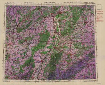
1:500,000 Europe (Air) G.S.G.S. No. 4072, Strasbourg
Sheet NE48-6 from the map series: 1:500,000 Europe (Air) G.S.G.S. No. 4072.
Abriss des Reinstroms
1 : 870000 Mollova mapová sbírka
Charte Von Mosel Saar Neccar-Rhein- und Mayn-Strom
1 : 780000 Mollova mapová sbírka Riegel, Christoph Riegel, Christoph
Grand theatre de la guerre sur les frontieres de France & d' Allemagne ou carte nouvelle du cours du Rhin et des pais circonvoisins contenant la Haute & Basse Alsace & le Palatinat & les electorats de Mayence, de Treves & une partie de Cologne de Hesse, de Franconie, de Baviere, le cercle de Souable le duché de Wurtenberg, de Brisgaw, de Bade, de Suntgaw & c. & c. & c
Francie Delisle, Guillaume Jean Covens & Corneille Mortier
Haut, Bas Rhin.
1 : 640000 Robert de Vaugondy, Gilles, 1688-1766
Süd-West Deutschland und Schweiz
Adolf Stieler's Handatlas über alle Theile der Erde und über das Weltgebäude Stieler, Adolf Justus Perthes
[Süd-West Deutschland und Schweiz, Nördlicher Theil]
Hand-Atlas über alle Theile der Erde und über das Weltgebäude Stieler, Adolf Justus Perthes
[Süd-West Deutschland und Schweiz, Nördlicher Theil]
Handatlas über alle Theile der Erde und über das Weltgebäude Stieler, Adolf Justus Perthes
Sud-West Deutschland Und Schweiz.
1 : 925000 Vogel, C.
Mappa in qua Armisonum Martis Theatrum, ad Rhenum et Mosellam geographico stilo Exacte delineatur
1 : 1200000 Mollova mapová sbírka
Tabula Nova Particularis Provincie Rheni Superioris [Karte], in: Claudii Ptolemei viri Alexandrini mathematice discipline philosophi doctissimi geographie opus [...], S. 278.
1 Karte aus Atlas Waldseemüller, Martin [und Ptolemaeus, Claudius] Übelin, Georg
Neueste Karte von Württemberg, Baden, Hohenzollern, die Rheinpfalz nebst den deutschen Reichslanden Elsass und Lothringen : zum Hand- und Comptoir-Gebrauch bearbeitet und namentlich mit Rücksicht auf Eisenbahnen als Reise- und Verkehrskarte angelegt
Baur, Carl Friedrich Wittwer
Grand Theatre de la Guerre sur les Frontieres de France & d'Allemagne
1 : 240000 Mollova mapová sbírka Delisle, Guillaume Ottens, Josua
Hessen-Nassau, Groszherzogtum Hessen und Furstentum Waldeck
1 : 500000 Scobel, Albert
Pars summa, seu Australis Superioris Rheni Circuli;
1 : 650000 Mollova mapová sbírka Valk, Gerhard Valck, Gerard
Übersichtskarte von Mittel - Europa
Grand theatre de la guerre, frontieres de France, d'Allemagne.
L'Isle, Guillaume de, 1675-1726
Composite: Rhin.
1 : 256000 L'Isle, Guillaume de, 1675-1726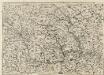
Abris Des Rheinstroms
Mollova mapová sbírka
Sveviae utriusque cum Germanicæ tum Rheticæ celebratissimis vrbibus
1 Karte : Kupferdruck ; 20 x 22 cm, Bildgrösse 21 x 29 cm Seltzlin; Quad; Bussemacher excudit Johan Buchsemecher
Palatinatus Ad Rhenum. [Karte], in: Novus atlas absolutissimus, Bd. 2, S. 189.
1 Karte aus Atlas Janssonius Offizin
Landgraviatus Alsatiae
1 : 340000 Alsasko (Francie) Homann, Johann Baptist Ioh. Baptista Homanno
Landgraviatus Alsatiae
1 : 340000 Alsasko (Francie) Homann, Johann Baptist J. B. Homann
Landgraviatus Alsatiae
1 : 340000 Alsasko (Francie) Homann, Johann Baptist Ioh. Baptista Homanno
Palatinatus Ad Rhenum [Karte], in: Novus Atlas, das ist, Weltbeschreibung, Bd. 1, S. 267.
1 Karte aus Atlas Blaeu, Joan Blaeu, Willem Janszoon
Teatre De La Guerre sur le Rhein, Moessele, Mayn, &c le Necker [Karte], in: Atlas nouveau, contenant toutes les parties du monde [...], Bd. 1, S. 229.
1 Karte aus Atlas Sanson, Nicolas Jaillot, Alexis Hubert und Mortier, Pieter
Grossherzogthum Baden
1 : 824000 Bádensko (Německo) Martin Gleditsch
Palatinatus Ad Rhenum [Karte], in: Theatrum orbis terrarum, sive, Atlas novus, Bd. 1, S. 257.
1 Karte aus Atlas Blaeu, Joan Blaeu, Willem Janszoon
Geographica Sueviæ universæ descriptio, 1
1 Blatt : Homännische Erben