Maps of Rhineland-Palatinate
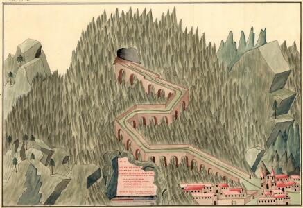
Plan des neien Kostranhren Wegs aus Carnte über den Loibl, von Seite miternacht anzusehen
Mollova mapová sbírka Geyer
Le cours du Rhin depuis Worms, jusqua Bonne et les pays adjaces / par Guillaume de l'Isle
1 : 220000 Isle, Guillaume de l' [Paris : Ph. Buache]
Cursus Rheni a Basilea usque ad Bonnam, III. sectionibus exhibitus
1 : 258000 Basilej (Švýcarsko) Delisle, Guillaume per Homannianos Heredes
Cursus Rheni a Basilea usque ad Bonnam, III. sectionibus exhibitus
1 : 258000 Basilej (Švýcarsko) Delisle, Guillaume per Homannianos Heredes
Circulus Franconicus ad occidentem vergens
1 Karte : Kupferdruck ; 37 x 32 cm Weigel; Kauffer Christoph Weigel
General Idèe Du Terrain qu'ont occupé nos Troupes tant dans la foret noire que le Long de L'inondation et du Rhin. La Campagne. 1735
Totius Rheni â fontibus usque ad Ostia Novissima Descriptio
1 : 550000 Mollova mapová sbírka Steudner, Johann P. Bodenehr, Johann Georg Steüdner, Johann Philipp
Germania Prima sive Superior cujus Metropolis Moguntiacum
1 : 875000 Mollova mapová sbírka Sanson, Guillaume Sanson, Guillaume
L'electorat de Mayence partie de la Hesse et du palatinat du Rhin
1 Karte : Kupferdruck ; 54 x 48 cm Le Rouge chez le Rouge ruë des Augustins vis a vis le Panier fleuri
Tertia Rheni Nova Tabula [Karte], in: Claud. Ptolemaeus. Geographia lat. cum mappis [...], S. 365.
1 Karte aus Atlas Münster, Sebastian [und Ptolemaeus, Claudius]
L'electorat de Mayence, le bas palatinat, et une partie du pays de Hesse et de la rivière du Mein
1 Karte : Kupferdruck ; 53 x 46 cm Condet chez Cóvens et Mortier
Carte des Rein Stroms
Basilej (Švýcarsko)
Abris Des Rheinstroms
Mollova mapová sbírka
Tertia Rheni Nova Tabula [Karte], in: Geographia universalis vetus et nova complectens Claudii Ptolemaei Alexandrini enarrationis libros VIII, S. 320.
1 Karte aus Atlas Münster, Sebastian [und Ptolemaeus, Claudius]
Electoratus Moguntinus
1 Karte : Kupferdruck ; 54 x 47 cm Homann Johann Baptist Homann
Carte des Pais qui sont situez éntre la Moselle, la Saare, le Rhein, et la Basse Alsace
1 : 260000 Mollova mapová sbírka Sanson, Guillaume Jaillot, Alexis Hubert
Charte des Rhein-Stroms von Breisach bis Linz auch als Post- u. Reise-Charte der umliegenden Länder brauchbar
1 : 617000 Breisach am Rhein (Německo) Streit, Friedrich Wilhelm Joseph Engelmann
Le Palatinat et Electorat du Rhein
1 : 260000 Mollova mapová sbírka Sanson, Guillaume Goeree, Jan Jaillot, Alexis Hubert
[Kaart], uit: Wyld's new map of the Rhine, from Rotterdam to Cologne, Coblenz, Mainz, Mannheim and Schrök : shewing every object interesting to the tourist
1 : 200000 London : Ja[me]s Wyld
Circulus Franconicus ad Occidentem vergent cum regionibus contiguis
1 : 640000 Mollova mapová sbírka Weigel, Christoph Weigel, Christoph I.
Le Palatinat Et Electorat Du Rhein Avec les Päis Voisins. [Karte], in: Atlas nouveau, contenant toutes les parties du monde [...], Bd. 1, S. 176.
1 Karte aus Atlas Sanson, Nicolas Jaillot, Alexis Hubert und Mortier, Pieter
Hassia Superior Cum tractu Rheni Ac Moeni atque adiacente Archiepiscopatu Moguntino, &c.
1 : 590000 Oberhessen mit Rhei- und Mainlauf und angrenzendem Erzbistum Mainz etc. Merian, Matthäus Merianische Erben
Electoratus Moguntinus
1 : 435000 Hesensko (Německo) Homann, Johann Baptist conante Ioh. Bapt. Homanno

Circuli Franconiæ pars occidentalis, exhibens simul integrum fere electoratum Moguntinum
1 Karte : Kupferdruck ; 54 x 47 cm Homann Johann Baptist Homann
1. Asperula cynanchica
Německo Lith. Anst. v. Wickelmann & Söhne
PALATINATVS | AD RHENVM.
Apud Guiljelmum Blaeu
Der Rheinstrohm von Basel bis Maynz
1 : 620000 Basilej (Švýcarsko) Engelman, J.
Palatinatus Rheni nova et accurata descriptio / magna cura in lucem editum per Nicolaum Joannis Piscatorem
1 : 450000 Annotatie: Met stadsgezichten boven de kaart op Mentz en Francfurt am Main, onder op Spier, Heydelberg, Wormbs, links op Arcis Electoralis Palatinae delineatio, Dolium enormae magnitudinis, Neuberg Closter, rechts op Heyligenberg en Wolfs Brunnen; links en rechts elk 2 afb. van klederdrachten, rechts 1 wapen en onder 2 wapens; Origineel is Blad 109 in atlas factice Claes Jansz. Visscher 1586/1587-1652 [Amsterodami] : [Nicolaus Joannis Piscator]