Maps of Rhineland-Palatinate

[Kaart], uit: Wyld's new map of the Rhine, from Rotterdam to Cologne, Coblenz, Mainz, Mannheim and Schrök : shewing every object interesting to the tourist
1 : 200000 London : Ja[me]s Wyld
1. Asperula cynanchica
Německo Lith. Anst. v. Wickelmann & Söhne
Quarta Rheni Et IX. Nova Tab. [Karte], in: Geographia universalis vetus et nova complectens Claudii Ptolemaei Alexandrini enarrationis libros VIII, S. 323.
1 Karte aus Atlas Münster, Sebastian [und Ptolemaeus, Claudius]
Karte des Rheinlaufes von Mannheim bis Düsseldorf von der Bergstrasse, den Main- und Lahn- Gegenden und den Bädern am Taunus
1 : 290000 Düsseldorf (Německo) Hoffmeister, F.L. Engelmann, Joseph Joseph Engelman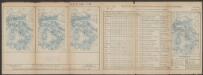
Quarta Rheni Et IX. Nova Tab. [Karte], in: Claud. Ptolemaeus. Geographia lat. cum mappis [...], S. 368.
1 Karte aus Atlas Münster, Sebastian [und Ptolemaeus, Claudius]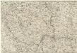
Totius Rheni â fontibus usque ad Ostia Novissima Descriptio
1 : 550000 Mollova mapová sbírka Steudner, Johann P. Bodenehr, Johann Georg Steüdner, Johann Philipp
Hassia Superior Cum tractu Rheni Ac Moeni atque adiacente Archiepiscopatu Moguntino, &c.
1 : 590000 Oberhessen mit Rhei- und Mainlauf und angrenzendem Erzbistum Mainz etc. Merian, Matthäus Merianische Erben
Archiepiscopatus Trevirensis Descriptio nova. [Karte], in: Gerardi Mercatoris et I. Hondii Newer Atlas, oder, Grosses Weltbuch, Bd. 1, S. 197.
1 Karte aus Atlas Mercator, Gerhard und Hondius, Jodocus Jansson, Jan
Sheet 2, uit: Stanford's large scale map of the seat of war / Stanford's Geographical Estab[lishmen]t
1 : 300000 Stanford's Geographical Establishment, Londen London : Stanford
Carte des Pais qui sont situez éntre la Moselle, la Saare, le Rhein, et la Basse Alsace
1 : 260000 Mollova mapová sbírka Sanson, Guillaume Jaillot, Alexis Hubert
6) III.E. ''Cologne'', uit: Carte géologique de France
1 : 500000 Annotatie: Voor aanwezige bladen zie bladoverzicht [S.l : s.n.]
Plan des neien Kostranhren Wegs aus Carnte über den Loibl, von Seite miternacht anzusehen
Mollova mapová sbírka Geyer
L'electorat de Mayence, le bas palatinat, et une partie du pays de Hesse et de la rivière du Mein
1 Karte : Kupferdruck ; 53 x 46 cm Condet chez Cóvens et Mortier
Palatinatus Rheni
1 : 340000 Mollova mapová sbírka Schenk, Pieter Schenk, Peter II
Hassia Superior Cum tractu Rheni ac Moeni atq; adiacente Archiepiscopatu Moguntino, &c.
1 : 590000 Mollova mapová sbírka Merian, Matthaeus Merian, Matthäus
Hassia Superior Cum tractu Rheni ac Moeni atq; adiacente Archiepiscopatu Moguntino, &c.
1 : 590000 Mollova mapová sbírka Merian, Matthaeus Merian, Matthäus
[Kaart], uit: Rheinlauf von Mainz bis Köln
Annotatie: Met beschrijving en ill. van bezienswaardigheden aan weerszijden van de kaart Köln : Bremer
Circulus Franconicus ad Occidentem vergent cum regionibus contiguis
1 : 640000 Mollova mapová sbírka Weigel, Christoph Weigel, Christoph I.
Freytag & Berndt ́s: Auto-Strassenkarten


Le Palatinat Et Electorat Du Rhein Avec les Päis Voisins. [Karte], in: Atlas nouveau, contenant toutes les parties du monde [...], Bd. 1, S. 176.
1 Karte aus Atlas Sanson, Nicolas Jaillot, Alexis Hubert und Mortier, Pieter
HASSIA SVPERIOR | et | MOGVNTINVS | ARCHIEPISCOPATVS
[Amsterdam : Joan Blaeu]
Electoratus Moguntinus
1 : 435000 Hesensko (Německo) Homann, Johann Baptist conante Ioh. Bapt. Homanno

Electoratus Moguntinus
1 Karte : Kupferdruck ; 54 x 47 cm Homann Johann Baptist Homann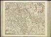
[55][55] Electoratus et Palatinatus Rheni ..., uit: Atlas sive Descriptio terrarum orbis
Annotatie: Gedigitaliseerde versie. Amsterdam. Heiloo : Picturae (vervaardiger), 2015. tiff-bestand. Gedigitaliseerd: 07-01-2015; Origineel: Universiteitsbibliotheek Vrije Universiteit (XL.05127.-) ; Netherlands; Titelpagina ontbreekt Wit, Frederik de Amsterdam : Frederick de Wit
Palatinatus Rheni nova, et accurata descriptio
1 : 520000 Frankfurt nad Mohanem (Německo) Visscher, Claes Jansz. per Nicolaum Joannis Piscatorem
Palatinatus Rheni Nova, Et Accurata Descriptio
1 : 520000 Mollova mapová sbírka Visscher, Nicolaes Visscher, Nicolaus I.

![[Kaart], uit: Wyld's new map of the Rhine, from Rotterdam to Cologne, Coblenz, Mainz, Mannheim and Schrök : shewing every object interesting to the tourist](https://images-2.georeferencer.com/images/iiif/767882259110/full/,300/0/native.jpg)

