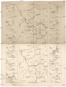
Maps of Rhineland-Palatinate

1. Asperula cynanchica
Německo Lith. Anst. v. Wickelmann & Söhne
S.R.I. Circulus Rhenanus Inferior Sive Electorum Rheni
1 : 620000 Mollova mapová sbírka Homann, Johann Baptist Homann, Johann Baptista
S.R.I. Circulus Rhenanus Inferior Sive Electorum Rheni
1 : 620000 Alsasko (Francie) Homann, Johann Baptist â Ioh. Baptista Homanno
Circulus Electorum Rheni Sive Rhenanus Inferior
1 : 620000 Mollova mapová sbírka Wit, Frederik de Gouwen, Giliam van der Covens, Johannes I
Hassia Superior Cum tractu Rheni Ac Moeni atque adiacente Archiepiscopatu Moguntino, &c.
1 : 590000 Oberhessen mit Rhei- und Mainlauf und angrenzendem Erzbistum Mainz etc. Merian, Matthäus Merianische Erben
[Kaart], uit: Wyld's new map of the Rhine, from Rotterdam to Cologne, Coblenz, Mainz, Mannheim and Schrök : shewing every object interesting to the tourist
1 : 200000 London : Ja[me]s Wyld
Circulus Franconicus ad Occidentem vergent cum regionibus contiguis
1 : 640000 Mollova mapová sbírka Weigel, Christoph Weigel, Christoph I.
Circulus Franconicus ad occidentem vergens
1 Karte : Kupferdruck ; 37 x 32 cm Weigel; Kauffer Christoph Weigel
L'electorat de Mayence, le bas palatinat, et une partie du pays de Hesse et de la rivière du Mein
1 Karte : Kupferdruck ; 53 x 46 cm Condet chez Cóvens et Mortier
Electoratus Moguntinus
1 : 435000 Hesensko (Německo) Homann, Johann Baptist conante Ioh. Bapt. Homanno
Electoratus Moguntinus
1 Karte : Kupferdruck ; 54 x 47 cm Homann Johann Baptist Homann

L'electorat de Mayence partie de la Hesse et du palatinat du Rhin
1 Karte : Kupferdruck ; 54 x 48 cm Le Rouge chez le Rouge ruë des Augustins vis a vis le Panier fleuri

Le Palatinat Et Electorat Du Rhein Avec les Päis Voisins. [Karte], in: Atlas nouveau, contenant toutes les parties du monde [...], Bd. 1, S. 176.
1 Karte aus Atlas Sanson, Nicolas Jaillot, Alexis Hubert und Mortier, Pieter
Circuli Franconiæ pars occidentalis, exhibens simul integrum fere electoratum Moguntinum
1 Karte : Kupferdruck ; 54 x 47 cm Homann Johann Baptist Homann
Carte des Pais qui sont situez éntre la Moselle, la Saare, le Rhein, et la Basse Alsace
1 : 260000 Mollova mapová sbírka Sanson, Guillaume Jaillot, Alexis Hubert
Quarta Rheni Et IX. Nova Tab. [Karte], in: Claud. Ptolemaeus. Geographia lat. cum mappis [...], S. 368.
1 Karte aus Atlas Münster, Sebastian [und Ptolemaeus, Claudius]
L'Electorat de Mayence, le Bas Palatinat, et une Partie du Pays de Hesse et de la Rivière du Mein
1 : 450000 Mollova mapová sbírka Condet, Johannes Covens, Johannes I
Totius Rheni â fontibus usque ad Ostia Novissima Descriptio
1 : 550000 Mollova mapová sbírka Steudner, Johann P. Bodenehr, Johann Georg Steüdner, Johann Philipp
[55][55] Electoratus et Palatinatus Rheni ..., uit: Atlas sive Descriptio terrarum orbis
Annotatie: Gedigitaliseerde versie. Amsterdam. Heiloo : Picturae (vervaardiger), 2015. tiff-bestand. Gedigitaliseerd: 07-01-2015; Origineel: Universiteitsbibliotheek Vrije Universiteit (XL.05127.-) ; Netherlands; Titelpagina ontbreekt Wit, Frederik de Amsterdam : Frederick de Wit
Freytag & Berndt ́s: Auto-Strassenkarten

Quarta Rheni Et IX. Nova Tab. [Karte], in: Geographia universalis vetus et nova complectens Claudii Ptolemaei Alexandrini enarrationis libros VIII, S. 323.
1 Karte aus Atlas Münster, Sebastian [und Ptolemaeus, Claudius]
Electoratus Moguntinus
1 : 440000 Mollova mapová sbírka Homann, Johann Baptist Homann, Johann Baptista
PALATINATVS | AD RHENVM.
Apud Guiljelmum Blaeu
Palatinatus Ad Rhenum [Karte], in: Novus Atlas, das ist, Weltbeschreibung, Bd. 1, S. 267.
1 Karte aus Atlas Blaeu, Joan Blaeu, Willem Janszoon

Palatinatus Ad Rhenum [Karte], in: Le théâtre du monde, ou, Nouvel atlas contenant les chartes et descriptions de tous les païs de la terre, Bd. 1, S. 296.
1 Karte aus Atlas Blaeu, Willem Janszoon und Blaeu, Joan Blaeu, Willem Janszoon
Palatinatus Ad Rhenum [Karte], in: Theatrum orbis terrarum, sive, Atlas novus, Bd. 1, S. 257.
1 Karte aus Atlas Blaeu, Joan Blaeu, Willem Janszoon