Maps of Rhineland-Palatinate

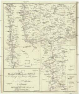
Karte des Rheinlaufes von Mannheim bis Düsseldorf von der Bergstrasse, den Main- und Lahn- Gegenden und den Bädern am Taunus
1 : 290000 Düsseldorf (Německo) Hoffmeister, F.L. Engelmann, Joseph Joseph Engelman
[Kaart], uit: Wyld's new map of the Rhine, from Rotterdam to Cologne, Coblenz, Mainz, Mannheim and Schrök : shewing every object interesting to the tourist
1 : 200000 London : Ja[me]s Wyld
Quarta Rheni Et IX. Nova Tab. [Karte], in: Geographia universalis vetus et nova complectens Claudii Ptolemaei Alexandrini enarrationis libros VIII, S. 323.
1 Karte aus Atlas Münster, Sebastian [und Ptolemaeus, Claudius]
Quarta Rheni Et IX. Nova Tab. [Karte], in: Claud. Ptolemaeus. Geographia lat. cum mappis [...], S. 368.
1 Karte aus Atlas Münster, Sebastian [und Ptolemaeus, Claudius]
Archiepiscopatus Trevirensis Descriptio nova. [Karte], in: Gerardi Mercatoris et I. Hondii Newer Atlas, oder, Grosses Weltbuch, Bd. 1, S. 197.
1 Karte aus Atlas Mercator, Gerhard und Hondius, Jodocus Jansson, Jan
[Kaart], uit: Rheinlauf von Mainz bis Köln
Annotatie: Met beschrijving en ill. van bezienswaardigheden aan weerszijden van de kaart Köln : Bremer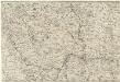
Totius Rheni â fontibus usque ad Ostia Novissima Descriptio
1 : 550000 Mollova mapová sbírka Steudner, Johann P. Bodenehr, Johann Georg Steüdner, Johann Philipp

6) III.E. ''Cologne'', uit: Carte géologique de France
1 : 500000 Annotatie: Voor aanwezige bladen zie bladoverzicht [S.l : s.n.]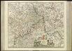
[56][56] Archiepiscopatus et Electoratus Trevirensis, uit: Atlas sive Descriptio terrarum orbis
Annotatie: Gedigitaliseerde versie. Amsterdam. Heiloo : Picturae (vervaardiger), 2015. tiff-bestand. Gedigitaliseerd: 07-01-2015; Origineel: Universiteitsbibliotheek Vrije Universiteit (XL.05127.-) ; Netherlands; Titelpagina ontbreekt Wit, Frederik de Amsterdam : Frederick de Wit
1. Asperula cynanchica
Německo Lith. Anst. v. Wickelmann & Söhne
[Kaart], uit: Rheinlauf von Mainz bis Köln : mit seitlicher Beschreibung
Annotatie: Met beschrijving en ill. van bezienswaardigheden aan weerszijden van de kaart Köln : Bremer
Archiepiscopatus ac electoratus Trevirensis et Eyfalia tractus novissima et accuratissima tabula
1 : 320000 1 Karte : Kupferdruck ; 48 x 54 cm Danckerts, Theodorus [Danckerts]

Der Rhein von Mainz bis Cöln
Kolín nad Rýnem (Německo) Kapp, D. Verlag von D. Kapp
[Kaart], uit: Gleumes' Rad- und Automobilkarte vom Mittelrhein
1 : 200000 Köln : Gleumes
Trevirensis archi-episcopatus et electoratus juxta omnes suas praefecturas cum confini tractu Eyfaliae recentissime et accuratissime delineat
1 : 337000 Eifel-oblast (Německo) Lotter, Tobias Conrad Seutter, Georg Matthäus Tob. Conr. Lotter
Trevirensis archi-episcopatus et electoratus juxta omnes suas praefecturas cum confini tractu Eyfaliae recentissime et accuratissime delineat
1 : 337000 Eifel-oblast (Německo) Lotter, Tobias Conrad Seutter, Georg Matthäus Tob. Conr. Lotter
Trevirensis archi-episcopatus et electoratus juxta omnes suas praefecturas cum confini tractu Eyfaliae recentissime et accuratissime delineat
1 : 337000 Eifel-oblast (Německo) Seutter, Matthäus Seutter, Georg Matthäus M. Seutter
Le Flambeau de la Guerre Allumee au Rhin
Mollova mapová sbírka Delisle, Guillaume Schenk, Peter II
Le Flambeau de la Guerre Allumee au Rhin
Mollova mapová sbírka Delisle, Guillaume Schenk, Peter II
Le Flambeau de la Guerre Allumee au Rhin
Mollova mapová sbírka Delisle, Guillaume Schenk, Peter II
Le Flambeau de la Guerre Allumee au Rhin
Mollova mapová sbírka Delisle, Guillaume Schenk, Peter II
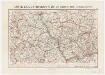
Sheet 2, uit: Stanford's large scale map of the seat of war / Stanford's Geographical Estab[lishmen]t
1 : 300000 Stanford's Geographical Establishment, Londen London : Stanford
Mosellae Fluminis tabula specialis, in qua Archiepiscopatus et Electoratus Trevirensis in suas praefecturas accurate divisus ut et Eyfaliae Tractus ostenditur
1 : 250000 Noribergae : sumtibus Joh. Baptista Homannus
Hassia Superior Cum tractu Rheni ac Moeni atq; adiacente Archiepiscopatu Moguntino, &c.
1 : 590000 Mollova mapová sbírka Merian, Matthaeus Merian, Matthäus
Hassia Superior Cum tractu Rheni ac Moeni atq; adiacente Archiepiscopatu Moguntino, &c.
1 : 590000 Mollova mapová sbírka Merian, Matthaeus Merian, Matthäus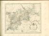

Sect. 17: Köln, uit: Geologische Karte des Deutschen Reichs in 27 Blaettern / [von] Richard Lepsius ; Red. von C. Vogel
1 : 500000 Annotatie: Blad 18 ontbreekt; Een aantal bladen op linnen; Een aantal bladen gereviseerd 1913-1914; Annotatie geografische gegevens: Met schaalstokken o.a. in kilometers; Legenda Carl Vogel 1828-1897 Gotha : Justus Perthes