Maps of Rhineland-Palatinate
Quarta Rheni Et IX. Nova Tab. [Karte], in: Claud. Ptolemaeus. Geographia lat. cum mappis [...], S. 368.
1 Karte aus Atlas Münster, Sebastian [und Ptolemaeus, Claudius]
Quarta Rheni Et IX. Nova Tab. [Karte], in: Geographia universalis vetus et nova complectens Claudii Ptolemaei Alexandrini enarrationis libros VIII, S. 323.
1 Karte aus Atlas Münster, Sebastian [und Ptolemaeus, Claudius]
Die Rheinlande nach ihren geologischen Beziehungen
1 : 560000 Leonhard, Gustav E. Schweizerbart's Verlagshandlung
Circvlvs Rhenanvs Inferior s. potius Electoralis integer complectens simul Partem mediam Circvli Rhenani Svperioris
1 : 1800000 Mollova mapová sbírka Franz, Johann Michael Homann, Johann Baptista - dědici
Rhein-Provinz, Nassau.
1 : 980000 Radefeld, Carl Christian Franz, 1788-1874
Synopsis circuli Rhenani inferioris sive electorum Rheni
1 Karte : Kupferdruck ; 48 x 55 cm Lotter Tobias Konrad Lotter
Synopsis circuli Rhenani inferioris sive electorum Rheni
1 Karte : Kupferdruck ; 48 x 56 cm Seutter Matthäus Seutter
Der Chur Rheinsiche- oder Nieder Rheinische Kreis
1 : 620000 Porýní-Falc (Německo) Güssefeld, Franz L. bey den Homännischen Erben
Der Chur Rheinsiche- oder Nieder Rheinische Kreis
1 : 620000 Porýní-Falc (Německo) Güssefeld, Franz L. bey den Homännischen Erben
Synopsis Circuli Rhenani Inferioris, Sive Electorum Rheni
1 : 620000 Mollova mapová sbírka Seutter, Matthäus Seutter, Matthäus
Uterque Rheni Circulus, Superior, et Inferior Electoralis, cum Palatinatu :
1 : 620000 Mollova mapová sbírka Valk, Gerhard Valck, Gerard
S.R.I. circulus Rhenanus inferior sive electorum Rheni
1 : 640000 Dolní Porýní (Německo) Homann, Johann Baptist a Ioh. Baptista Homanno
S.R.I. circulus Rhenanus inferior sive electorum Rheni
1 : 640000 Dolní Porýní (Německo) Homann, Johann Baptist a Ioh. Baptista Homanno
S.R.I. circulus Rhenanus inferior sive electorum Rheni
1 : 640000 Dolní Porýní (Německo) Homann, Johann Baptist a Ioh. Baptista Homanno
S. R. I. circulus Rhenanus inferior sive electorum Rheni
1 : 660000 Kolín nad Rýnem (Německo) Homann, Johann Baptist J.B. Homann
S.R.I. circulus Rhenanus inferior sive electorum Rheni
1 : 640000 Dolní Porýní (Německo) Homann, Johann Baptist á Ioh. Baptista Homanno
Le Cercle Eslectoral du Rhein subdivisé et touts les Estats qui le composent
1 : 560000 Mollova mapová sbírka Sanson, Guillaume Jaillot, Alexis Hubert
Teutschlands Nieder Rheinischer Creiss mit seinen abgetheilten Provintzen
1 : 2600000 Mollova mapová sbírka Weigel, Christoph Weigel, Christoph I.
S. R. I. Rhenanus Inferior sive Electorum Rheni

Dioecesis Coloniensis
1 : 650000 Kolín nad Rýnem-oblast (Německo)
S.R.I. Circulus Rhenanus Inferior Sive Electorum Rheni
1 : 620000 Mollova mapová sbírka Homann, Johann Baptist Homann, Johann Baptista
S.R.I. Circulus Rhenanus Inferior Sive Electorum Rheni
1 : 620000 Alsasko (Francie) Homann, Johann Baptist â Ioh. Baptista Homanno
Circulus Electorum Rheni Sive Rhenanus Inferior
1 : 620000 Mollova mapová sbírka Wit, Frederik de Gouwen, Giliam van der Covens, Johannes I
Berghe Ducatus Marck Comitatus et Coloniensis Dioecesis [Karte], in: Gerardi Mercatoris et I. Hondii Newer Atlas, oder, Grosses Weltbuch, Bd. 1, S. 176.
1 Karte aus Atlas Mercator, Gerhard und Hondius, Jodocus Jansson, Jan
Berghe Ducatus Marck Comitatus et Coloniensis Dioecesis [Karte], in: Gerardi Mercatoris Atlas, sive, Cosmographicae meditationes de fabrica mundi et fabricati figura, S. 346.
1 Karte aus Atlas Mercator, Gerhard Montanus, Petrus
Das Kriegstheater an der Rhein & Mainlinie
1 : 990000 Porýní-Falc (Německo) Meyer, A. litogr. Maschinendruck von A. Meyer
Kreise der Rheinprovinz 1864
Preußen, Rheinprovinz, Verwaltungsgliederung Kunz, Andreas ; Moeschl, Joachim Robert
Tractvs Rhenanvs Inferior excusus cura
1 : 810000 Mollova mapová sbírka Weigel, Magdalena Esther Weigel, Johann Christoph - vdova

Berghe ducatus Marck comitatus et Coloniensis diœcesis
1 Karte : Kupferdruck ; 31 x 45 cm Mercator; Hondius excusum apud Henricum Hondium sub insigno Atlantis
Berghe ducatus Marck comitatus et Coloniensis diœcesis
1 Karte : Kupferdruck ; 34 x 44 cm Mercator; Hondius excusum apud Henricum Hondium sub insigno Atlantis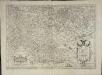
Berghe ducatus Marck comitatus et Coloniensis diœcesis
1 Karte : Kupferdruck ; 31 x 45 cm Mercator; Hondius excusum apud Henricum Hondium sub insigno Atlantis
![Quarta Rheni Et IX. Nova Tab. [Karte], in: Claud. Ptolemaeus. Geographia lat. cum mappis [...], S. 368.](https://images-2.georeferencer.com/images/iiif/510635204380/full/,300/0/native.jpg)

