Maps of Rhineland-Palatinate

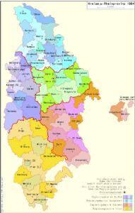
Kreise der Rheinprovinz 1864
Preußen, Rheinprovinz, Verwaltungsgliederung Kunz, Andreas ; Moeschl, Joachim Robert

Die Preussische Rhein-Provinz und das Herzogthum Nassau
Grosser Hand-Atlas über alle Theile der Erde in 170 Karten Meyer, J. Verlag des Bibliographischen Instituts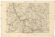
Das Kriegstheater an der Rhein & Mainlinie
1 : 990000 Porýní-Falc (Německo) Meyer, A. litogr. Maschinendruck von A. Meyer
Rhein-Provinz, Nassau.
1 : 980000 Radefeld, Carl Christian Franz, 1788-1874
Rhein Provinz.
1 : 825000 Flemming, Carl
Geologische Übersichtskarte der Rheinprovinz und der Provinz Westfalen / bearb. von H. von Dechen
1 : 500000 Annotatie: Oorspr. uitg.: 1866 Heinrich von Dechen Berlin : Schropp
Geologische Übersichtskarte der Rheinprovinz und der Provinz Westfalen / bearb. von H. von Dechen
1 : 500000 Heinrich von Dechen Berlin : Schropp
S.R.I. circulos Rhenanus inferior sive electorum Rheni
1 : 632000 Kolín nad Rýnem-oblast (Německo) Homann, Johann Baptist â Ioh. Baptista Homanno
S. R. I. circulus Rhenanus inferior sive electorum Rheni
1 : 624000 Kolín nad Rýnem (Německo) Homann, Johann Baptist I. B. Homann
Synopsis Circuli Rhenani Inferioris sive Electorum Rheni, exhibens Archi Episcopatum Moguntinum, Coloniensem, Trevirensem et Palatinatum Rheni, Comitatus Beilstein, Newenaer, Isenburg Infer. et Reifferscheid
1 : 800000 ob oculos posita a Matth. Seutter Aug. Vind : Matth. Seutter
Der Nider Rheinische Crais samt Dessen angrenzenden Landern
1 : 560000 Mollova mapová sbírka
Synopsis circuli Rhenani inferioris sive electorum Rheni
1 Karte : Kupferdruck ; 48 x 55 cm Lotter Tobias Konrad Lotter
Synopsis circuli Rhenani inferioris sive electorum Rheni
1 Karte : Kupferdruck ; 48 x 56 cm Seutter Matthäus Seutter
Teutschlands Nieder Rheinischer Creiss mit seinen abgetheilten Provintzen
1 : 2600000 Mollova mapová sbírka Weigel, Christoph Weigel, Christoph I.
Die Preussische Provinz Sachsen
1 : 600000 Geographisches Institut (Weimar, Germany)
Synopsis circuli Rhenani inferioris sive electorum Rheni
1 : 620000 Porýní-Falc (Německo) Lotter, Tobias Conrad Tobias Conrad Lotter
Synopsis circuli Rhenani inferioris sive electorum Rheni
1 : 620000 Porýní-Falc (Německo) Lotter, Tobias Conrad T. C. Lotter
Synopsis circuli Rhenani inferioris sive electorum Rheni
1 : 620000 Porýní-Falc (Německo) Lotter, Tobias Conrad Tobias Conrad Lotter
SYNOPSIS CIRCULI RHENANI INFERIORIS sive ELECTORUM RHENI
1 : 640000 Porýní-Falc (Německo) Seutter, Matthäus a Matth. Seutter
Synopsis circuli Rhenani inferioris sive electorum Rheni
1 : 620000 Porýní-Falc (Německo) Seutter, Matthäus Matthäus Seutter
Carte des cercles du Haut et Bas Rhin
1 : 1000000 Alsasko (Francie) Mentelle, Edme Tardieu, Pierre François
Synopsis Circuli Rhenani Inferioris, Sive Electorum Rheni
1 : 620000 Mollova mapová sbírka Seutter, Matthäus Seutter, Matthäus
Tabula Nova Circuli Electoralis Rheni, ad Usum Serenissimi Burgundae Ducis
1 : 670000 Mollova mapová sbírka Jaillot, Alexis-Hubert Ottens, Josua
Tabula Nova Circuli Electoralis Rheni, ad Usum Serenissimi Burgundae Ducis
1 : 670000 Mollova mapová sbírka Jaillot, Alexis-Hubert Jaillot, Alexis Hubert

[Vestfálsko]
Vestfálsko (Německo)
Circolo Elettorale del Reno
1 : 730000 Mollova mapová sbírka Mariotti, Vincenzo De Rossi, Giovanni Giacomo
Upper, Lower Rhine circles.
1 : 700000 Cary, John, ca. 1754-1835