Maps of Rhineland-Palatinate

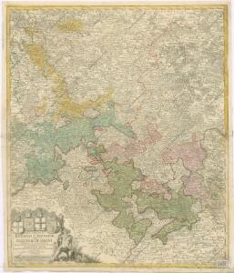
S. R. I. Rhenanus Inferior sive Electorum Rheni


Tabula Nova Circuli Electoralis Rheni, ad Usum Serenissimi Burgundae Ducis
1 : 670000 Mollova mapová sbírka Jaillot, Alexis-Hubert Ottens, Josua
Tabula Nova Circuli Electoralis Rheni, ad Usum Serenissimi Burgundae Ducis
1 : 670000 Mollova mapová sbírka Jaillot, Alexis-Hubert Jaillot, Alexis Hubert
Teutschlands Nieder Rheinischer Creiss mit seinen abgetheilten Provintzen
1 : 2600000 Mollova mapová sbírka Weigel, Christoph Weigel, Christoph I.
Circolo Elettorale del Reno
1 : 730000 Mollova mapová sbírka Mariotti, Vincenzo De Rossi, Giovanni Giacomo
Uterque Rheni Circulus, Superior, et Inferior Electoralis, cum Palatinatu :
1 : 620000 Mollova mapová sbírka Valk, Gerhard Valck, Gerard
Le Cercle Eslectoral du Rhein subdivisé et touts les Estats qui le composent sur les Memoires le plus Nouveaux
1 : 560000 Mollova mapová sbírka Sanson, Guillaume Cordier, Louis Jaillot, Alexis Hubert
S.R.I. circulus Rhenanus inferior sive electorum Rheni
1 : 640000 Dolní Porýní (Německo) Homann, Johann Baptist a Ioh. Baptista Homanno
S.R.I. circulus Rhenanus inferior sive electorum Rheni
1 : 640000 Dolní Porýní (Německo) Homann, Johann Baptist a Ioh. Baptista Homanno
S.R.I. circulus Rhenanus inferior sive electorum Rheni
1 : 640000 Dolní Porýní (Německo) Homann, Johann Baptist a Ioh. Baptista Homanno
S. R. I. circulus Rhenanus inferior sive electorum Rheni
1 : 660000 Kolín nad Rýnem (Německo) Homann, Johann Baptist J.B. Homann
S.R.I. circulus Rhenanus inferior sive electorum Rheni
1 : 640000 Dolní Porýní (Německo) Homann, Johann Baptist á Ioh. Baptista Homanno
Circvlvs Rhenanvs Inferior s. potius Electoralis integer complectens simul Partem mediam Circvli Rhenani Svperioris
1 : 1800000 Mollova mapová sbírka Franz, Johann Michael Homann, Johann Baptista - dědici
Le Cercle Eslectoral du Rhein subdivisé et touts les Estats qui le composent
1 : 560000 Mollova mapová sbírka Sanson, Guillaume Jaillot, Alexis Hubert
S.R.I. Circulus Rhenanus Inferior Sive Electorum Rheni
1 : 620000 Alsasko (Francie) Homann, Johann Baptist â Ioh. Baptista Homanno
S.R.I. Circulus Rhenanus Inferior Sive Electorum Rheni
1 : 620000 Mollova mapová sbírka Homann, Johann Baptist Homann, Johann Baptista
S. R. I. circulus Rhenanus inferior sive electorum Rheni
1 : 624000 Kolín nad Rýnem (Německo) Homann, Johann Baptist I. B. Homann
Geographisch-statistische Post- und Resekarte zu den besuchtesten Rhein- und Main-Gegenden
1 : 831500 Mohan (Německo) Bauerkeller, Georg J.P. Streng
Le Cercle Eslectorial Du Rhein subdivié entous les Estats qui le composent [Karte], in: Atlas nouveau, contenant toutes les parties du monde [...], Bd. 1, S. 290.
1 Karte aus Atlas Sanson, Nicolas Jaillot, Alexis Hubert und Mortier, Pieter
Circulus Electorum Rheni Sive Rhenanus Inferior
1 : 620000 Mollova mapová sbírka Wit, Frederik de Gouwen, Giliam van der Covens, Johannes I
Der Chur Rheinsiche- oder Nieder Rheinische Kreis
1 : 620000 Porýní-Falc (Německo) Güssefeld, Franz L. bey den Homännischen Erben
Der Chur Rheinsiche- oder Nieder Rheinische Kreis
1 : 620000 Porýní-Falc (Německo) Güssefeld, Franz L. bey den Homännischen Erben
S.R.I. circulos Rhenanus inferior sive electorum Rheni
1 : 632000 Kolín nad Rýnem-oblast (Německo) Homann, Johann Baptist â Ioh. Baptista Homanno

Westdeutschland
Volksschul-Atlas über alle Teile der Erde Lange, Henry Druck und Verlag von Georg Westermann
Haut, Bas Rhin.
1 : 640000 Robert de Vaugondy, Gilles, 1688-1766
Der Oberrheinische u. Churrheinische Kreis
Allgemeiner Atlas [Walch, Johannes] im Verlag bei Johannes Walch
Synopsis Circuli Rhenani Inferioris sive Electorum Rheni, exhibens Archi Episcopatum Moguntinum, Coloniensem, Trevirensem et Palatinatum Rheni, Comitatus Beilstein, Newenaer, Isenburg Infer. et Reifferscheid
1 : 800000 ob oculos posita a Matth. Seutter Aug. Vind : Matth. Seutter