Maps of Carpathian Mountains
Totius Regni Hungariae maximaeque partis Danubii fluminis, una cum adjacentibus et finitimis regionibus novissima delineatio / per Nicolaum Visscher
1 : 2000000 Annotatie: Origineel is Blad 130 in atlas factice; Annotatie geografische gegevens: Met 2 schaalstokken Nicolaes Jansz. Visscher jr. 1649-1702 [Amsterdam : per Nicolaum Visscher]
Danubius, Fluvius Europae Maximus, A Fontibus Ad Ostia, Cum omnibus Fluminibus, ab utroque latere, in allum defluentibus. [Karte], in: Le théâtre du monde, ou, Nouvel atlas contenant les chartes et descriptions de tous les païs de la terre, Bd. 1, S. 222.
1 Karte aus Atlas Blaeu, Willem Janszoon und Blaeu, Joan Blaeu, Willem Janszoon
Totius Regni Hungariae, Maximaeque Partis Danubii Fluminis, una cum adjacentibus et finitimis Regionibus Novissima Delineatio [Karte], in: Novus atlas absolutissimus, Bd. 2, S. 293.
1 Karte aus Atlas Janssonius Offizin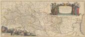
Danubius, Fluvius Europae Maximus, A Fontibus Ad Ostia, Cum omnibus Fluminibus, ab utroque latere, in illum defluentibus. [Karte], in: Novus Atlas, das ist, Weltbeschreibung, Bd. 1, S. 191.
1 Karte aus Atlas Blaeu, Joan Blaeu, Willem Janszoon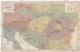
Völker und Sprachen Karte von Österreich und den Unter-Donau-Ländern
1 : 3000000 Rakousko-Uhersko Kiepert, Heinrich Dietrich Reimer
Völker und Sprachen Karte von Österreich und den Unter-Donau-Ländern
1 : 3000000 Evropa střední Kiepert, Heinrich D. Reimer
Völker und Sprachen Karte von Österreich und den Unter-Donau-Ländern
Rakousko-Uhersko Kiepert, Heinrich Riegel, Christoph Dietrich Reimer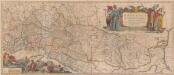
Danubius. Fluvius Europae Maximus. A Fontibus Ad Ostia. Cum omnibus Fluminib. ab utroque latere, in illum fluentibus. [Karte], in: Novus atlas absolutissimus, Bd. 2, S. 238.
1 Karte aus Atlas Janssonius Offizin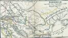
Pannonien zur Zeit des Svatopluk 895
1 : 15000000 Pannonien Swatopluk I., Mähren, Herzog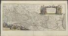
DANVBIVS, | FLUVIUS EUROPÆ MAXIMUS, | A FONTIBVS AD OSTIA. | Cum omnibus Fluminibus, ab utroque latere, | in illum defluentibus.
[Amsterdam : Joan Blaeu]
Danubius, Fluvius Europae Maximus. A Fontibus Ad Ostia, Cum omnibus Fluminis, ab utroque latere, in illum fluentibus. [Karte], in: Gerardi Mercatoris et I. Hondii Newer Atlas, oder, Grosses Weltbuch, Bd. 1, S. 233.
1 Karte aus Atlas Mercator, Gerhard und Hondius, Jodocus Jansson, Jan
Ungarn nach dem Ersten Weltkrieg
Ungarn Weltkrieg <1914-1918>, Grenze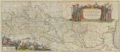
Danubius, Fluvius Europae Maximus, A Fontibus Ad Ostia. Cum omnibus Fluminibus, ab utroque latere, in illum defluentibus. [Karte], in: Theatrum orbis terrarum, sive, Atlas novus, Bd. 1, S. 310.
1 Karte aus Atlas Blaeu, Joan Blaeu, Willem Janszoon
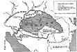
Karpaten-Länder
Donau-Karpaten-Gebiet
Prochaska ́s Neue Eisenbahnkarte von Österreich-Ungarn für 1898
Ungarn 1938-1944
Ungarn Weltkrieg <1939-1945>, Grenze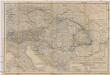
Oesterreichisch-ungarische Monarchie
1 : 2500000 Rakousko-Uhersko Geographisches Institut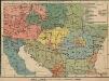
Österreich-Ungarn. Völker
1 : 9000000 Österreich-Ungarn Ethnische Gruppe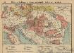
Österreich-Ungarn. Landwirtschaft und Fischerei
1 : 9000000 Österreich-Ungarn Landwirtschaft, Fischerei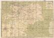
Eisenbahn-Karte der oesterreichisch-ungarischen Monarchie
1 : 1228000 Budapešť (Maďarsko : oblast) Beer, Josef A. Hartleben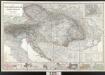
Der österreichische Kaiserstaat
Berghaus, Hermann; Stülpnagel, Friedrich von; Petermann, August; Habenicht, Hermann Perthes
Der Donauraum
1 : 1500000 Dunaj-oblast Justus Perthes
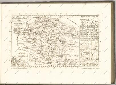
Galizien, Ungarn mit Slavonien und Croatien, Siebenbürgen und Dalmatien, Moldau, Wallachey
Hand-Atlas über alle Theile der Erde nach dem neuesten Zustande und über das Weltgebäude Stieler, Adolf bei Justus Perthes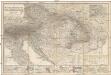
Das Österreichisch-Ungarische Reich
1 : 1850000 Rakousko-Uhersko Berghaus, Hermann Eulenstein, F. Justus Perthes
Rakousko-Uhersko, mapa národopisná
1 : 2750000 Banát Machát, František J. Otto
Östereich-Ungarn
1 : 1500000 Rakousko-Uhersko Mittelbach's Verlag
Österreich-Ungarn. Rumänien, Serbien, Montenegro, Bulgarien & Ost-Rumelien
Adolf Stieler's Handatlas über alle Theile der Erde und über das Weltgebäude Stieler, Adolf Justus Perthes
Artaria's Eisenbahnkarte
1 : 1500000 Evropa jihovýchodní Peucker, Karl Artaria