Maps of Khust Raion


Gorgany Zachodnie
1 : 100000 Lenkiewicz, Adam Książnica-Atlas
Bereg és Ugocsa vármegye térképe
1 : 300000 Kogutowicz, Manó Magyar Földrajzi Intézet
Comitat Beregh-Ugocsa
1 : 288000 Mukačevo (Ukrajina)
Comitat Beregh-Ugocsa
1 : 290000 Berehove (Ukrajina : oblast)
C. Bereghiensis
Ungarn Ukraine Komitat Bereg

Munkacs.
from Spezialkarte der osterreichisch-ungarischen Monarchie.
Bilke.
from Spezialkarte der osterreichisch-ungarischen Monarchie.
Mukačevo
1 : 75000 Ukrajina Vojenský zeměpisný ústav
Berezna und Szinever.
from Spezialkarte der osterreichisch-ungarischen Monarchie.
Beregszasz und Mezo-Tarpa.
from Spezialkarte der osterreichisch-ungarischen Monarchie.
Bilky
1 : 75000 Ukrajina Vojenský zeměpisný ústav
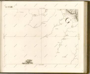
Chust
1 : 75000 Ukrajina Vojenský zeměpisný ústav
Nacy-Szollos und Huszt.
from Spezialkarte der osterreichisch-ungarischen Monarchie.
Munkács
1 : 75000 Mukatschewe, Umland Geripp: Leut. Kimlein. Terrain: Oberlt. Boltek
III. vojenské mapování 4770
1 : 75000
III. vojenské mapování 4671
1 : 75000
Berezna und Szinevér
1 : 75000 Transkarpatien Schrift u. Gerippe v. W. Ahl. Terrainschraffirung v. Lieut. Jonak Edler v. Freyenwald
Nacy-Szőllős und Huszt
1 : 75000 Transkarpatien, Khust Geripp: Feldw. Watterich. Terrain: J. Fitz
III. vojenské mapování 4769
1 : 75000
Berezna und Szinevér
1 : 75000 Transkarpatien Schrift u. Gerippe v. W. Ahl. Terrainschraffirung v. Lieut. Jonak Edler v. Freyenwald
Beregszász und Mező-Tarpa
1 : 75000 Transkarpatien, Berehove Geripp: Feldw. König. Terrain: Hauptm. v. Jonak u. Hauptm. Trica
Zone 12, Kol. XXIX, Berezna und Szinevér, uit: [Geologische Specialkarte der im Reichsrathe vertretenen Königreiche und Länder der österreichisch-ungarischen Monarchie] / geologische Aufnahmen der königl. ung. Geologischen Anstalt
1 : 75000 Annotatie: Verantwoordelijkheidsvermelding in 1909 veranderd in: Königliche Ungarische Geologische Reichsanstalt; Sommige bladen in het Frans; Annotatie geografische gegevens: Coördinaten gebaseerd op nulmeridiaan van Ferro (Hierro) Königliche Ungarische Geologische Reichsanstalt; Königliche Ungarische Geologische Anstalt Budapest : [Königliche Ungarische Geologische Anstalt]
III. vojenské mapování 4670
1 : 75000
Bilke
1 : 75000 Transkarpatien, Bilky Geripp: Oberlt. Schubert. Terrain: Hauptm. Pokorny Edl. v. Fürstenschild
Tecso und Kovesliget (Ungarn).; Spezialkarte der osterreichisch-ungarischen Monarchie.
from Spezialkarte der osterreichisch-ungarischen Monarchie. Austro-Hungarian Monarchy. Militärgeographisches Institut.,
Berehovo a okolí
1 : 75000 Vojenský zeměpisný ústav
III. vojenské mapování 4771
1 : 75000