Maps of Mukachevo

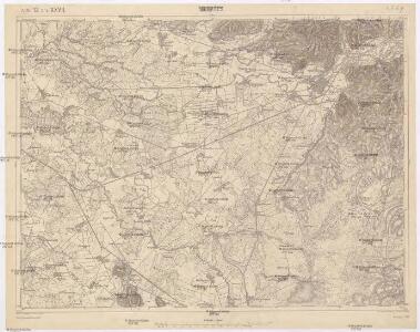
Munkács
1 : 75000 Ukrajina Boltek K. u. k. Militärgeographisches Institut
Munkács
1 : 75000 Mukatschewe, Umland Geripp: Leut. Kimlein. Terrain: Oberlt. Boltek
III. vojenské mapování 4669
1 : 75000
[Mapový list]
1 : 25000 Vojenský zeměpisný ústav
Mukačevo
1 : 75000 Ukrajina Vojenský zeměpisný ústav
Munkacs.
from Spezialkarte der osterreichisch-ungarischen Monarchie.
III. vojenské mapování 4668/4
1 : 25000
Bereg és Ugocsa vármegye térképe
1 : 300000 Kogutowicz, Manó Magyar Földrajzi Intézet

C. Bereghiensis
Ungarn Ukraine Komitat Bereg

Comitat Beregh-Ugocsa
1 : 288000 Mukačevo (Ukrajina)
Comitat Beregh-Ugocsa
1 : 290000 Berehove (Ukrajina : oblast)

Gorgany Zachodnie
1 : 100000 Lenkiewicz, Adam Książnica-Atlas
Generální mapa ČSR

Sväzok dokladov... prác na štátnej hranici medzi Československou republikou a Sväzom sovietských republik, ...

Sväzok dokladov... prác na štátnej hranici medzi Československou republikou a Sväzom sovietských republik, ...

C. Ungvár
Slowakei Ukraine Komitat Uschgorod
Sväzok dokladov... prác na štátnej hranici medzi Československou republikou a Sväzom sovietských republik, ...

Sväzok dokladov... prác na štátnej hranici medzi Československou republikou a Sväzom sovietských republik, ...

Ung vármegye térképe
1 : 310000 Slovensko Kogutowicz, Manó Magyar Földrajzi Intézet
Ung-vármegye térképe
1 : 310000 Slovensko Magyar Földrajzi Intézet
Szerednye.
from Spezialkarte der osterreichisch-ungarischen Monarchie.
Berehovo a okolí
1 : 75000 Vojenský zeměpisný ústav
Beregszasz und Mezo-Tarpa.
from Spezialkarte der osterreichisch-ungarischen Monarchie.
Mandok und Csap (Ungarn).; Spezialkarte der osterreichisch-ungarischen Monarchie.
from Spezialkarte der osterreichisch-ungarischen Monarchie. Austro-Hungarian Monarchy. Militärgeographisches Institut.,
III. vojenské mapování 4668
1 : 75000
Mándok
1 : 75000 Szabolcs-Szatmár-Bereg
Seredné
1 : 75000 Ukrajina Vojenský zeměpisný ústav
Seredné
1 : 75000 Ukrajina Vojenský zeměpisný ústav
Linz und Eferding
1 : 75000 Linec Vojenský zeměpisný ústav