Maps of Іршава

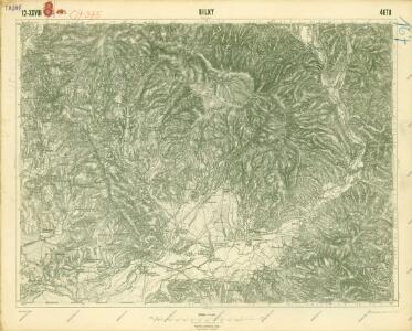
III. vojenské mapování 4670
1 : 75000
Bilke
1 : 75000 Transkarpatien, Bilky Geripp: Oberlt. Schubert. Terrain: Hauptm. Pokorny Edl. v. Fürstenschild
Bilky
1 : 75000 Ukrajina Vojenský zeměpisný ústav
Bilke.
from Spezialkarte der osterreichisch-ungarischen Monarchie.
Bereg és Ugocsa vármegye térképe
1 : 300000 Kogutowicz, Manó Magyar Földrajzi Intézet
C. Bereghiensis
Ungarn Ukraine Komitat Bereg

Comitat Beregh-Ugocsa
1 : 288000 Mukačevo (Ukrajina)
Comitat Beregh-Ugocsa
1 : 290000 Berehove (Ukrajina : oblast)
Gorgany Zachodnie
1 : 100000 Lenkiewicz, Adam Książnica-Atlas

C. Ugocsiensis
Rumänien Ukraine Komitat Ugocsa

Szolyva.
from Spezialkarte der osterreichisch-ungarischen Monarchie.
Nacy-Szollos und Huszt.
from Spezialkarte der osterreichisch-ungarischen Monarchie.
Mukačevo
1 : 75000 Ukrajina Vojenský zeměpisný ústav
Berezna und Szinever.
from Spezialkarte der osterreichisch-ungarischen Monarchie.
Munkacs.
from Spezialkarte der osterreichisch-ungarischen Monarchie.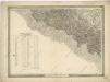
General-Karte des Königreiches Galizien und des Herzogthumes Bukovina
Neubertova generální automapa Republiky československé
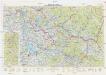
1 : 200000 Chust (Ukrajina) Soukup, Jan V. Neubert a synové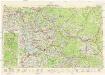
Neubertova generální automapa Republiky československé
1 : 200000 Chust (Ukrajina) Soukup, Jan V. Neubert a synové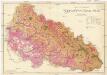
Podkarpatská Rus
1 : 225000 Podkarpatská Rus (Ukrajina) Gregor, František Novotný a Bartošek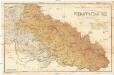
Podkarpatská Rus
1 : 225000 Podkarpatská Rus (Ukrajina) Gregor, František Novotný a Bartošek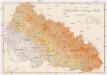
Podkarpatská Rus
1 : 225000 Podkarpatská Rus (Ukrajina) Gregor, František Novotný a Bartošek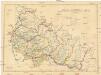
Podkarpatská Rus
1 : 300000 Podkarpatská Rus (Ukrajina) Referát min. veř. prací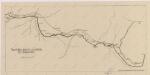
Sbírka map a diagramů použitých na mírových konferencích v Paříži v letech 1919 - 1920

Podkarpatská Rus
1 : 500000 Berehove (Ukrajina) Fastr Eduard
Slovensko

Podkarpatská Rus
1 : 300000 Berehove (Ukrajina) Fastr Eduard
Ober Ungern
Rumunsko severní im Verlage des Kunst und Industrie Comptoirs