Maps of Khust Raion

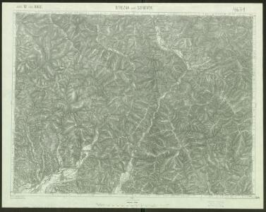
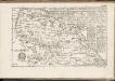
Berezna und Szinevér
1 : 75000 Transkarpatien Schrift u. Gerippe v. W. Ahl. Terrainschraffirung v. Lieut. Jonak Edler v. Freyenwald
III. vojenské mapování 4671
1 : 75000
Berezna und Szinevér
1 : 75000 Transkarpatien Schrift u. Gerippe v. W. Ahl. Terrainschraffirung v. Lieut. Jonak Edler v. Freyenwald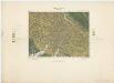
Zone 12, Kol. XXIX, Berezna und Szinevér, uit: [Geologische Specialkarte der im Reichsrathe vertretenen Königreiche und Länder der österreichisch-ungarischen Monarchie] / geologische Aufnahmen der königl. ung. Geologischen Anstalt
1 : 75000 Annotatie: Verantwoordelijkheidsvermelding in 1909 veranderd in: Königliche Ungarische Geologische Reichsanstalt; Sommige bladen in het Frans; Annotatie geografische gegevens: Coördinaten gebaseerd op nulmeridiaan van Ferro (Hierro) Königliche Ungarische Geologische Reichsanstalt; Königliche Ungarische Geologische Anstalt Budapest : [Königliche Ungarische Geologische Anstalt]
A Kalocsai m. kir. erdögondnokság A és B üzemosztályának átnézeti térképe
1 : 23000 Klösz Gy. és fia
Berezna und Szinever.
from Spezialkarte der osterreichisch-ungarischen Monarchie.
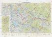
Horinčovo
1 : 75000 Ukrajina Vojenský zeměpisný ústav

Gorgany Zachodnie
1 : 100000 Lenkiewicz, Adam Książnica-Atlas
Okormezo (Galizien).
from Spezialkarte der osterreichisch-ungarischen Monarchie.
Brusztura.
from Spezialkarte der osterreichisch-ungarischen Monarchie.
Bilke.
from Spezialkarte der osterreichisch-ungarischen Monarchie.
III. vojenské mapování 4571
1 : 75000

Generalkarte von Zentraleuropa

Máramaros vármegye térképe
1 : 500000 Maramureş (Rumunsko) Kogutowicz, Manó Magyar Földrajzi Intézet
General-Karte des Königreiches Galizien und des Herzogthumes Bukovina
C. Marmarus
Rumänien Komitat Marmarosch
Comitat Marmaros
1 : 288000 Maramureş (Rumunsko)
Comitat Marmaros
1 : 280000 Marmarošská Sihoť (Rumunsko : oblast)
Generalkarte von Zentraleuropa
Neubertova generální automapa Republiky československé
1 : 200000 Chust (Ukrajina) Soukup, Jan V. Neubert a synové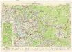
Neubertova generální automapa Republiky československé
1 : 200000 Chust (Ukrajina) Soukup, Jan V. Neubert a synové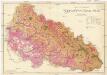
Podkarpatská Rus
1 : 225000 Podkarpatská Rus (Ukrajina) Gregor, František Novotný a Bartošek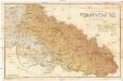
Podkarpatská Rus
1 : 225000 Podkarpatská Rus (Ukrajina) Gregor, František Novotný a Bartošek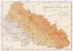
Podkarpatská Rus
1 : 225000 Podkarpatská Rus (Ukrajina) Gregor, František Novotný a Bartošek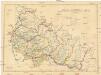
Podkarpatská Rus
1 : 300000 Podkarpatská Rus (Ukrajina) Referát min. veř. prací
Sbírka map a diagramů použitých na mírových konferencích v Paříži v letech 1919 - 1920

Podkarpatská Rus
1 : 500000 Berehove (Ukrajina) Fastr Eduard