Maps of Ringebu

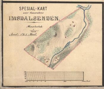
Spesial-kart over Gaardene Imsdalsenden
1 : 5000 J. Sejersted | K. M. Norum
31D 4
1 : 50000 Vilhelm Christian Marius Ødegaard
1818-2 Hirkjølen
1 : 50000 Statens kartverk
1818-2 Imsdalen
1 : 50000 Statens kartverk
31B 11; 31B 12; 31D 2; 31D 3; 31D 4
1 : 100000 Ramm
32A 9; 32A 10
1 : 50000 Anders Lagesen
1818-2 Imsdalen
1 : 50000 Norges Geografiske Oppmåling
31D Sollia
1 : 100000
1818-2 Hirkjølen
1 : 50000 Statens kartverk
1818-2 Imsdalen
1 : 50000 Norges Geografiske Oppmåling
1818-2 Imsdalen
1 : 50000 Statens kartverk
1918-3 Koppang
1 : 50000 Statens kartverk
31D Sollia
1 : 100000 Torgrim Lundtvedt | Einar Sigurd Ween
31D Søndre Fron
1 : 100000 H. Hagen | Torgrim Lundtvedt
31D Søndre Fron
1 : 100000 Torgrim Lundtvedt | H. Hagen
Geologiske kart 48: Den geologiske kartlægning, Søndre Fron
1 : 100000 W. Werenskiold Norges geologiske undersøkelse
31D Ringebu
1 : 100000 Einar Sigurd Ween | Torgrim Lundtvedt
Geologiske kart 64: Den geologiske Undersøgelse, Gausdal
1 : 100000 K. O. Bjørlykke | Torgrim Lundtvedt Norges Geografiske Opmaaling
Kartblad 59: Militair Vey-Cart over det Ringeboiske Compagnie District
P. Weybey
Portefølje nr 47
1 : 100000 Duncker | Munthe
Portefølje nr 47
1 : 100000 Duncker | Munthe
Geologisk kart 95: Stor-Elvdal
1 : 100000 Emil Moestue Norges geologiske undersøkelse
Spesielle kart 22-4: Koppang - Lilleelvdal
1 : 400000 Albert Cammermeyer Forlag
5527 Lillehammer
1 : 100000
Spesielle kart 22-6: Rena - Stai
1 : 400000 Albert Cammermeyer Forlag
Kartblad 166b-2: Wej-Cart over det Aamodske Compagnie; 166b-2

Spesielle kart 103-6: Flötningskart over Glommens vassdrag
1 : 1000 Einar Sigurd Ween
Kartblad 166b-3: Wej-Cart over det Aamodske Compagnie; 166b-3

Østerdalen
1 : 250000