Maps of Åmot

Spesielle kart 22-6: Rena - Stai
1 : 400000 Albert Cammermeyer Forlag
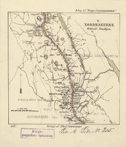
Kartblad 166b-3: Wej-Cart over det Aamodske Compagnie; 166b-3
Geologisk kart 95: Stor-Elvdal
1 : 100000 Emil Moestue Norges geologiske undersøkelse
Portefølje nr 48
1 : 100000 Schilling
Portefølje nr 48
1 : 100000 Schilling
Geologisk kart 32a: Den Geologiske Undersøgelse, Rektangel 26 Åmot
1 : 100000 P. Krohn | Ths. Münster | Øgaard Norges geologiske undersøkelse
Geologisk kart 32b: Den Geologiske Undersøgelse, Rektangel 26 Åmot
1 : 100000 Øgaard | Ths. Münster | P. Krohn Norges geologiske undersøkelse
26C Åmot
1 : 100000
26C Åmot
1 : 100000 C. Pedersen | Arnt Magnus Andreassen Øgaard
32A Stor-Elvdal
1 : 100000 Torgrim Lundtvedt | Ole Engh
26C Åmot
1 : 100000 C. Pedersen | Arnt Magnus Andreassen Øgaard
26C Åmot
1 : 100000 Nicolai Franck | Arnt Magnus Andreassen Øgaard
32A Stor-Elvdal
1 : 100000 Ole Engh | Torgrim Lundtvedt
26C Åmot
1 : 100000 Arnt Magnus Andreassen Øgaard | C. Pedersen
32A Storelvedalen
1 : 100000 Johan Nordhagen | Torgrim Lundtvedt
32A Stor-Elvdal
1 : 100000 Torgrim Lundtvedt | Ole Engh
26C Åmot
1 : 100000 C. Pedersen | Arnt Magnus Andreassen Øgaard
32A Stor-Elvdal
1 : 100000 Torgrim Lundtvedt | Ole Engh
1917-4 Myklebysjøen
1 : 50000 Statens kartverk
1917-2 Rena
1 : 50000 Statens kartverk
1917-3 Åsmark
1 : 50000 Statens kartverk
2017-3 Julussa
1 : 50000 Norges Geografiske Oppmåling
32A 9; 32A 10
1 : 50000 Anders Lagesen
1917-4 Möklebysjöen
1 : 50000 Norges Geografiske Oppmåling
32A 2; 32A 6
1 : 50000 Johannes Solem | Einar Halle
32A 9; 32A 10
1 : 50000 Anders Lagesen
32A 3; 32A 4; 32A 7; 32A 8
1 : 50000 Johannes Solem
32A 11; 32A 12
1 : 50000 Severin Vincents Heiberg Segelcke
32A 11; 32A 12
1 : 50000 Severin Vincents Heiberg Segelcke