Maps of Øyer

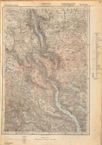
5527 Lillehammer
1 : 100000
25D Lillehammer
1 : 100000 Einar Sigurd Ween | Johan Ferdinand Normann
Trigonometrisk grunnlag, Squelet-Cart 29: Skelet-kart over Oppland og Hedmark 1807 og 1810
Hans Lemmich Juell
Trigonometrisk grunnlag, dublett 29- Kart over trigonometriske punkter foretatt i 1807 og 1810
Hans Lemmich Juell
Trigonometrisk grunnlag, dublett 29-2: Kart over trigonometriske punkter foretatt i 1807 og 1810
Hans Lemmich Juell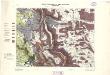
Geologiske kart 64: Den geologiske Undersøgelse, Gausdal
1 : 100000 K. O. Bjørlykke | Torgrim Lundtvedt Norges Geografiske Opmaaling
Portefølje nr 47
1 : 100000 Duncker | Munthe
Portefølje nr 47
1 : 100000 Duncker | Munthe
25D Lillehammer
1 : 100000 Johan Ferdinand Normann
25D Lillehammer
1 : 100000 Einar Sigurd Ween | Johan Ferdinand Normann
31B Gausdal
1 : 100000
31B Gausdal
1 : 100000 Torgrim Lundtvedt | Johan Nordhagen
31B Gausdal
1 : 100000 Torgrim Lundtvedt | C. Pedersen
25D Lillehammer
1 : 100000 Johan Ferdinand Normann
31B Gausdal
1 : 100000 Torgrim Lundtvedt | Johan Nordhagen
31B Gausdal
1 : 100000 Johan Nordhagen | Torgrim Lundtvedt
25D Lillehammer
1 : 100000 Johan Ferdinand Normann | Ole Engh
Kartblad 52: Militært Cart over det Gusdalske Compagnies District
Keilhau
Kartblad 62: Charte over det Faabergske Compagnie District

31B Gausdal
1 : 100000 C. Pedersen | Torgrim Lundtvedt
F31 aust Synnfjell
1 : 100000
F31 aust Synnfjell
1 : 100000
G31-7; G31-8
1 : 50000 A. H.
1817-4 Fåvang
1 : 50000 Statens kartverk
25D Lillehammer
1 : 100000
1817-1 Goppollen
1 : 50000 Statens kartverk
1817-1 Goppollen
1 : 50000 Statens kartverk
1817-4 Fåvang
1 : 50000 Statens kartverk
1817-3 Follebu
1 : 50000 Norges Geografiske Oppmåling