Maps of Philippines

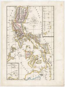
Islas Filipinas / por C. Alabern
1 mapa. Alabern, C.
Mapa de las yslas Philipinas
1 : 3100000
REDUZIRTE-KARTE VON DEN PHILIPPINEN und den SULU INSELN
1 : 2400000 Filipíny Berghaus, Heinrich Karl Wilhelm Aragon, Ildefonso de Justus Perthes
Carte Hydrographique & Chorographique des ISLES PHILIPPINES
1 : 2000000 Filipíny Murillo Velarde, Pedro Bagay, Nicolás de la Cruz par les Heritiers de Homann
[Islas filipinas - distribution de temblores]
Atlas de Filipinas Algué, P. José Government Printing Office
[Islas filipinas - estaciones meteorologico-seismicas]
Atlas de Filipinas Algué, P. José Government Printing Office
[Islas filipinas - mapa general]
Atlas de Filipinas Algué, P. José Government Printing Office
No. 3. Mapa Etnografico.
1 : 6000000 U.S. Coast and Geodetic Survey
No. 4. Mapa Orografico.
1 : 6000000 U.S. Coast and Geodetic Survey
Mapa de las Islas Filipinas : formado expresamente para "El Correo Espaÿûnol" / por el topografo D. José Mendez
Madrid : Mendez
[Islas filipinas - mapa orografico]
Atlas de Filipinas Algué, P. José Government Printing Office
Chart of the Philippine Islands, from the Spanish chart in 1808, the adjacent islands are added from the lastest surveys
1 : 1660000 Arrowsmith, Arron Arrowsmith, Aaron
[Islas filipinas - mapa etnografico]
Atlas de Filipinas Algué, P. José Government Printing Office
Reduzirte Karte von den Philippinen und den Sulu-Inseln
1 : 2356000 den Manen Don Alexandro ́s Malaspina, Espinosa y Tello's, [...] Don Ildefonso de Aragon gewidmet vom Verfasser [H. Berghaus] gest. v. Selmar Siebert Gotha : Perthes
Philippine Islands.
1 : 2471000 Rand McNally and Company
Philippines.
1 : 2280000 Rand McNally and Company
127. Philippines. The World Atlas.
1 : 5000000 USSR (Union of Soviet Socialist Republics).
No. 2. Mapa General.
1 : 6000000 U.S. Coast and Geodetic Survey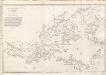
A collection of charts prepared from various sources by Alexander Dalrymple, Philipinas, 1794
[A collection of charts prepared from various sources by Alexander Dalrymple and showing the coasts of West and South Africa, the Indian Ocean, Malay Archipelago, China, the Moluccas and New Holland] London : Alexander Dalrymple.
Carta particolare dell'Isole Fillipine è di Luzon
1 : 2000000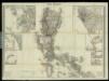
Islas Filipinas, 1a hoja / por el teniente coronel de ingenieros D. Francisco Coello ; las notas estadisticas e historicas han sido escritas por D. Pascual Madoz
1 : 1000000 1 full d'un mapa en tres fulls, b/n. Dins: Atlas de España y sus posesiones de ultramar Coello, Francisco ; Madoz, Pascual [Imprenta del Atlas de España]
A collection of charts prepared from various sources by Alexander Dalrymple, Philipinas, 1788
[A collection of charts prepared from various sources by Alexander Dalrymple and showing the coasts of West and South Africa, the Indian Ocean, Malay Archipelago, China, the Moluccas and New Holland] London : Alexander Dalrymple.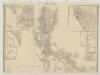
[Islas Filipinas, Primera Hoja Central]
1 : 1000000 Morata, Antonio [Verlag nicht ermittelbar]
Islas Filipinas, 2a hoja / por el teniente coronel de ingenieros D. Francisco Coello ; las notas estadisticas e historicas han sido escritas por D. Pascual Madoz
1 : 1000000 1 full d'un mapa en tres fulls, b/n. Dins: Atlas de España y sus posesiones de ultramar Coello, Francisco ; Madoz, Pascual [Imprenta del Atlas de España]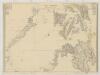
[Islas Filipinas, Segunda Hoja Central]
1 : 1000000 Morata, Antonio [Verlag nicht ermittelbar]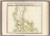
Partie, Iles Philippines. Oceanique no. 4.
1 : 1641836 Vandermaelen, Philippe, 1795-1869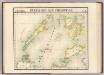
Partie, Iles Philippines. Oceanique no. 6.
1 : 1641836 Vandermaelen, Philippe, 1795-1869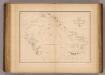
Sooloo Sea, Archipelago.
1 : 3600000 United States Exploring Expedition (1838-1842)
Luzon, Philippine Islands.
1 : 2408000 Rand McNally and Company