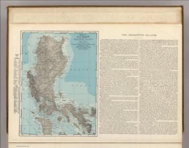
Maps of Luzon

Luzon, Philippine Islands.
1 : 2408000 Rand McNally and Company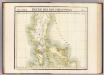
Partie, Iles Philippines. Oceanique no. 4.
1 : 1641836 Vandermaelen, Philippe, 1795-1869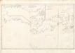
A collection of charts prepared from various sources by Alexander Dalrymple, Luzon, 1788
[A collection of charts prepared from various sources by Alexander Dalrymple and showing the coasts of West and South Africa, the Indian Ocean, Malay Archipelago, China, the Moluccas and New Holland] London : Alexander Dalrymple.
No. 7. Luzon.
1 : 920000 U.S. Coast and Geodetic Survey
[Islas filipinas - Luzon]
Atlas de Filipinas Algué, P. José Government Printing Office
No. 8. Luzon.
1 : 723000 U.S. Coast and Geodetic Survey
[Islas filipinas - Luzon]
Atlas de Filipinas Algué, P. José Government Printing Office
No. 10. Luzon.
1 : 670000 U.S. Coast and Geodetic Survey
No. 11. Luzon.
1 : 670000 U.S. Coast and Geodetic Survey
[Islas filipinas - Luzon]
Atlas de Filipinas Algué, P. José Government Printing Office
[Islas filipinas - Luzon]
Atlas de Filipinas Algué, P. José Government Printing Office
No. 9. Luzon.
1 : 535000 U.S. Coast and Geodetic Survey
[Islas filipinas - Luzon]
Atlas de Filipinas Algué, P. José Government Printing Office
No. 15. Mindoro.
1 : 807000 U.S. Coast and Geodetic Survey
[Islas filipinas - Mindoro]
Atlas de Filipinas Algué, P. José Government Printing Office
[Islas filipinas - Infantay Polillo]
Atlas de Filipinas Algué, P. José Government Printing Office
No. 12. Infanta y Polillo.
1 : 390000 U.S. Coast and Geodetic Survey
No. 29. Bahia de Manila.
1 : 227000 U.S. Coast and Geodetic Survey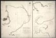
Carta esférica de la bahía de Manila trabajada de orden del Rey á borda de las corvetas descubierta y atrevída de la Marína Real en 1792
Spain. Dirección de Hidrografía Spain. Dirección de Hidrografía
[Islas filipinas - Bahla de Manila]
Atlas de Filipinas Algué, P. José Government Printing Office
[Islas filipinas - Catanduanes]
Atlas de Filipinas Algué, P. José Government Printing Office
A collection of charts prepared from various sources by Alexander Dalrymple, Luzon, 1797
[A collection of charts prepared from various sources by Alexander Dalrymple and showing the coasts of West and South Africa, the Indian Ocean, Malay Archipelago, China, the Moluccas and New Holland] London : Alexander Dalrymple.
No. 14. Catanduanes.
1 : 195000 U.S. Coast and Geodetic Survey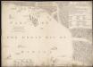
A plan of the reduction of Manila and Cavita
Cornish, Samuel, Sir Jefferys, Thomas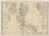
[Islas Filipinas, Primera Hoja Central]
1 : 1000000 Morata, Antonio [Verlag nicht ermittelbar]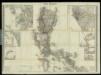
Islas Filipinas, 1a hoja / por el teniente coronel de ingenieros D. Francisco Coello ; las notas estadisticas e historicas han sido escritas por D. Pascual Madoz
1 : 1000000 1 full d'un mapa en tres fulls, b/n. Dins: Atlas de España y sus posesiones de ultramar Coello, Francisco ; Madoz, Pascual [Imprenta del Atlas de España]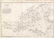
A collection of charts prepared from various sources by Alexander Dalrymple, Philipinas, 1794
[A collection of charts prepared from various sources by Alexander Dalrymple and showing the coasts of West and South Africa, the Indian Ocean, Malay Archipelago, China, the Moluccas and New Holland] London : Alexander Dalrymple.
A collection of charts prepared from various sources by Alexander Dalrymple, Philipinas, 1788
[A collection of charts prepared from various sources by Alexander Dalrymple and showing the coasts of West and South Africa, the Indian Ocean, Malay Archipelago, China, the Moluccas and New Holland] London : Alexander Dalrymple.
No. 13. Batanes y Babuyanes.
1 : 930000 U.S. Coast and Geodetic Survey