Maps of Syria

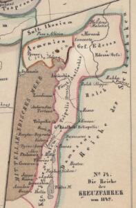
Die Reiche der Kreuzfahrer um 1142
Kreuzfahrerstaaten
Die Reiche der Kreuzfahrer um 1142
Levante, Kreuzfahrerstaaten
Syria.
1 : 3801600 Tallis, J. & F.
Die sogenannten Missionen der Central-TürkeiDas Gebiet der Nestorianer

Syriae.
1 : 2400000 Vivien de St Martin, L.
Syria.
1 : 6500000 Fenner, Rest.
Ancient Syria to Sinai.
1 : 2200000 Society for the Diffusion of Useful Knowledge (Great Britain)
Syrie et de la Palestine, 624 ans apres J.C.
1 : 3300000 Houze, Antoine Philippe
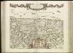
Syrien und die angraenzenden Laender zur Zeit der Kreuzzuge.
1 : 3000000 Spruner von Merz, Karl
La nvova et esatta descrittione della Soria, e della Terra Santa
Kypr Forlani, Paolo da Paulo Furlani Veronese
Terre Sainte en 1839.
1 : 3300000 Houze, Antoine Philippe
Syrie et Palestine. Asie 63.
1 : 1641836 Vandermaelen, Philippe, 1795-1869
Syria
1 : 2200000 Hughes, William, 1817-1876 George Cox
Terre Sainte, pendant la premiere croisade de 1096 a 1144.
1 : 3300000 Houze, Antoine Philippe
La Palestine...
Syriæ, sive Soriæ : nova et accurata descriptio
1 : 1300000 Annotatie: Kaart vervaardigd in ca. 1658; Kaart uitg. tussen ca. 1658-ca. 1680; Origineel is Blad 182 in atlas factice; Annotatie geografische gegevens: Schaalstokken op kaart: 15 Milliaria Germanica Communia (=8,3 cm), en: 20 Milliaria Gallica Communia (=8,3 cm) Johannes Janssonius 1588-1664 Amstelodami : sumptibus Ioannis Ianssonii
Syriae. Sive Soriae. Nova et Accurata descriptio. [Karte], in: Novus atlas absolutissimus, Bd. 6, S. 105.
1 Karte aus Atlas Janssonius Offizin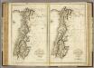
Ancient and Modern Syria.
1 : 1770000 Playfair, Principal
Feuille No. 9, uit: Carte de la Turquie d'Asie (moins l'Arabie) / dessiné et héliogravé au Service géographique de l'Armée
1 : 1000000 titelvariant: Turquie d'Asie; Annotatie: Titel boven de kaart: Turquie d'Asie; Bl. genummerd 1-4 en 7-10; Met lijst van de meest gebruikte woorden op de kaart vertaald uit het Turks, Arabisch en Perzisch; Annotatie geografische gegevens: Inzetkrt. op bl. 9: Plan de Jérusalem et de ses environs, Plan d'Alep, Plan de Damas et de ses faubourgs, Plan de Beyrout et de ses environs (alle 1:50.000) Service géographique de l'Armée [S.l. : Service géographique de l'Armée]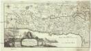
Carte de la Terre Promise
1 : 1600000 Izrael
Iudaea seu Terra Sancta quae Hebraeorum sive Israelitarum in suas duodecim Tribus divisa; secretis ab invicem Regnis Iuda, et Israel [...] [Karte], in: Atlas nouveau, contenant toutes les parties du monde [...], Bd. 2, S. 212.
1 Karte aus Atlas Sanson, Nicolas Jaillot, Alexis Hubert und Mortier, Pieter
Palaestina
Grosser Hand-Atlas über alle Theile der Erde in 170 Karten Meyer, J. Verlag des Bibliographischen Instituts
Terre Sainte depuis la deuxieme croisade.
1 : 3300000 Houze, Antoine Philippe
Palaestina.
1 : 1140000 Flemming, Carl

Palestine
1 : 1000000 Colton, G.W.
Terra Sancta XVI. Nova Tab. [Karte], in: Geographia universalis vetus et nova complectens Claudii Ptolemaei Alexandrini enarrationis libros VIII, S. 344.
1 Karte aus Atlas Münster, Sebastian [und Ptolemaeus, Claudius]
Judaea seu duodecim tribus Israelis
1 : 10670000 Izrael Bonne, Rigobert André
Terra Sancta XXIII. Nova Tabula. [Karte], in: Claud. Ptolemaeus. Geographia lat. cum mappis [...], S. 431.
1 Karte aus Atlas Münster, Sebastian [und Ptolemaeus, Claudius]