Maps of Homs (Hims)

Syriae. Sive Soriae. Nova et Accurata descriptio. [Karte], in: Novus atlas absolutissimus, Bd. 6, S. 105.
1 Karte aus Atlas Janssonius Offizin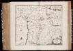
Syriæ, sive Soriæ : nova et accurata descriptio
1 : 1300000 Annotatie: Kaart vervaardigd in ca. 1658; Kaart uitg. tussen ca. 1658-ca. 1680; Origineel is Blad 182 in atlas factice; Annotatie geografische gegevens: Schaalstokken op kaart: 15 Milliaria Germanica Communia (=8,3 cm), en: 20 Milliaria Gallica Communia (=8,3 cm) Johannes Janssonius 1588-1664 Amstelodami : sumptibus Ioannis Ianssonii
Ancient and Modern Syria.
1 : 1770000 Playfair, Principal
Palaestina.
1 : 1140000 Flemming, Carl
Geognostische Karte des Taurus und seinen Nebenzweige in den Paschaliken Adana und Marasch, nebst dem angrenzenden Theile des Paschalikes von Aleppo
1 : 600000 Taurus, pohoří (Turecko) Russegger, Joseph E. Schweizerbart'schen Buchhandlung
Karte des Taurus und seinen Nebenzweige in den Paschaliken Adana und Marasch, nebst dem angrenzenden Theile des Paschalikes von Aleppo
1 : 600000 Taurus, pohoří (Turecko) Russegger, Joseph E. Schweizerbart'schen Buchhandlung
Karte des Taurus und seiner Nebenzweige in den Paschaliken Adana und Marasch, nebst dem angrenzenden Theile des Paschalikes von Aleppo
1 : 600000 Taurus, pohoří (Turecko) Russegger, Joseph im k. k. Militärisch-geographischen Institute
Geognostische Karte des Libanon und Antilibanon in Sirien
1 : 290000 Libanon Rufsegger, Josef E. Schweizerbart'sche Buchhandlung
Carte géologique du Liban
1 : 200000 Zumoffen, Godefroy Paris : Henry Barrère
Palestine.
1 : 1077120 Lucas, Fielding Jr.
Palestine or the Holy Land, Or the Land of Canaan.
1 : 950400 Burr, David H., 1803-1875
KARTE von SYRIEN
1 : 450000 Sýrie Berghaus, Heinrich Karl Wilhelm Burckhardt, Johann Ludwig Justus Perthes
Karte von Syrien
1 : 450000 Sýrie Berghaus, Heinrich Karl Wilhelm Burckhardt Justus Perthes
Palestine, or the Holy Land, Or the Land of Canaan.
1 : 940000 Greenleaf, Jeremiah
Palestine, or the Holy Land, Or the Land of Canaan.
1 : 940000 Greenleaf, Jeremiah
Karte von Syrien
1 : 450000 den Manen Jacotins und Burckhardts gewidmet von H. Berghaus gest. von Herterich, Siebert u. Rolle Gotha : Perthes
[Palestina]
Palestina Schmidt, Johann Marius Friedrich Franz
Beyrouth (Beirut), 1934
Levant. [Carte de reconnaissance de la Syrie et du Liban ... sous mandat Français.] 1 : 200,000. Beyrouth : Bureau Topographique des Troupes Françaises du Levant
Karte der asiatischen Türkei
1 : 200000 Turecko Kartogr. Abteilung der Kgl. Preuß. Landesaufnahme
47 Tyre, Sidon.
1 : 100000 Jacotin, Pierre, 1765-1827
Composite: Sheets 1-47
1 : 100000 Jacotin, Pierre, 1765-1827
Sheet II. Palestine Exploration Map.
1 : 63360 Kitchener, H.R. (Horatio Herbert)
Karte der Gegend zwischen Bofanti und Tarsus
1 : 100000 Tarsus (Turecko) Kartographische Abteilung des Stellvertr. Generalstab der Armee
Levant 1:50.000 E
1 : 50000 Libanon Service géographique de l'Armée
Levant, Ouroum Es Sourhra
From a 1:50,000 scale map series of the Levant. GSGS 8061, sheet 50.P.7, second edition. Geographical Section General Staff, War Office
Levant, Maarret Enn Naamane
From a 1:50,000 scale map series of the Levant. GSGS 8061, sheet 50.N.9, first edition. Geographical Section General Staff
Kartenbild von Aleppo und seiner näheren Umgebung
1 : 25000 Aleppo (Sýrie) Vermessungs-Abtlg. 27 der Heeresgruppe F
Plan of Hims / drawn by A. Tomeh
E.J.Brill Leiden Leiden : Late E.J. Brill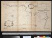
De reede van St. Jan de Acari en Kaijfa met t Land van Sidon of Saita
Israel Gerard van Keulen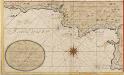
![Syriae. Sive Soriae. Nova et Accurata descriptio. [Karte], in: Novus atlas absolutissimus, Bd. 6, S. 105.](https://images-2.georeferencer.com/images/iiif/601028886009/full/,300/0/native.jpg)

