Maps of Jordan

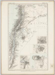
Feuille No. 9, uit: Carte de la Turquie d'Asie (moins l'Arabie) / dessiné et héliogravé au Service géographique de l'Armée
1 : 1000000 titelvariant: Turquie d'Asie; Annotatie: Titel boven de kaart: Turquie d'Asie; Bl. genummerd 1-4 en 7-10; Met lijst van de meest gebruikte woorden op de kaart vertaald uit het Turks, Arabisch en Perzisch; Annotatie geografische gegevens: Inzetkrt. op bl. 9: Plan de Jérusalem et de ses environs, Plan d'Alep, Plan de Damas et de ses faubourgs, Plan de Beyrout et de ses environs (alle 1:50.000) Service géographique de l'Armée [S.l. : Service géographique de l'Armée]
Syrie et Palestine. Asie 63.
1 : 1641836 Vandermaelen, Philippe, 1795-1869
La nvova et esatta descrittione della Soria, e della Terra Santa
Kypr Forlani, Paolo da Paulo Furlani Veronese
Syria
1 : 2200000 Hughes, William, 1817-1876 George Cox
Palaestina
Grosser Hand-Atlas über alle Theile der Erde in 170 Karten Meyer, J. Verlag des Bibliographischen Instituts
Palestine
1 : 1000000 Colton, G.W.
Palaestina.
1 : 1140000 Flemming, Carl
Holy Land, XII Tribes.
1 : 1450000 Bowen, Emanuel
Judaea seu duodecim tribus Israelis
1 : 10670000 Izrael Bonne, Rigobert André
Ancient and Modern Syria.
1 : 1770000 Playfair, Principal
Syriæ, sive Soriæ : nova et accurata descriptio
1 : 1300000 Annotatie: Kaart vervaardigd in ca. 1658; Kaart uitg. tussen ca. 1658-ca. 1680; Origineel is Blad 182 in atlas factice; Annotatie geografische gegevens: Schaalstokken op kaart: 15 Milliaria Germanica Communia (=8,3 cm), en: 20 Milliaria Gallica Communia (=8,3 cm) Johannes Janssonius 1588-1664 Amstelodami : sumptibus Ioannis Ianssonii
Palestine.
1 : 714649 Johnston, Alexander Keith
Palestine & Adjacent Countries.
1 : 1150000 Tanner, Henry S.
Palestine.
1 : 714649 Johnston, Alexander Keith
Palestine.
1 : 714649 Johnston, Alexander Keith, 1804-1871
Palestine.
1 : 60800000 Johnson, A.J.
Palästina
Hand-Atlas über alle Theile der Erde und über das Weltgebäude Stieler, Adolf Justus Perthes
Map of Syria

151. Palestine and Lebanon. The World Atlas.
1 : 1250000 USSR (Union of Soviet Socialist Republics).
Palestine.
1 : 60800000 Johnson, A.J.
Palestine.
1 : 60800000 Johnson, A.J.
Palaestina.
1 : 1220000 Radefeld, Carl Christian Franz, 1788-1874
Palastina. Das Libanon-Gebiet.
1 : 1200000 Petermann, A.
Carta della Palestina sotto il dominio de' Romani.
1 : 805000 Marzolla, Benedetto
Palästina
Handatlas über alle Theile der Erde und über das Weltgebäude Stieler, Adolf Justus Perthes
Palästina und Libanon
Adolf Stieler's Handatlas über alle Theile der Erde und über das Weltgebäude Stieler, Adolf Justus Perthes
Palestine & Adjacent Countries.
1 : 1160000 Mitchell, Samuel Augustus
Terra Sancta XXIII. Nova Tabula. [Karte], in: Claud. Ptolemaeus. Geographia lat. cum mappis [...], S. 431.
1 Karte aus Atlas Münster, Sebastian [und Ptolemaeus, Claudius]
Syriae. Sive Soriae. Nova et Accurata descriptio. [Karte], in: Novus atlas absolutissimus, Bd. 6, S. 105.
1 Karte aus Atlas Janssonius Offizin