Maps of Jordan

Palaestina
Grosser Hand-Atlas über alle Theile der Erde in 170 Karten Meyer, J. Verlag des Bibliographischen Instituts
Palestine
1 : 1000000 Colton, G.W.
151. Palestine and Lebanon. The World Atlas.
1 : 1250000 USSR (Union of Soviet Socialist Republics).
Terra Sancta XXIII. Nova Tabula. [Karte], in: Claud. Ptolemaeus. Geographia lat. cum mappis [...], S. 431.
1 Karte aus Atlas Münster, Sebastian [und Ptolemaeus, Claudius]
Terra Sancta, sive Promessionis, olim Palestina / recens delineata, et in lucem edita per Nicolaum Visscher
1 : 900000 Annotatie geografische gegevens: West boven Visscher, Nicolaes (1618-1679) [Amsterdam : C.J. Visscher]
Terra Sancta XVI. Nova Tab. [Karte], in: Geographia universalis vetus et nova complectens Claudii Ptolemaei Alexandrini enarrationis libros VIII, S. 344.
1 Karte aus Atlas Münster, Sebastian [und Ptolemaeus, Claudius]
Judaea seu duodecim tribus Israelis
1 : 10670000 Izrael Bonne, Rigobert André

Palaestina.
1 : 1140000 Flemming, Carl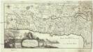
Carte de la Terre Promise
1 : 1600000 Izrael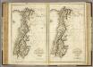
Ancient and Modern Syria.
1 : 1770000 Playfair, Principal
Palästina
Hand-Atlas über alle Theile der Erde und über das Weltgebäude Stieler, Adolf Justus Perthes
Terre Sainte divisee en royaumes d'Israel et de Juda de 975 a 588.
1 : 2700000 Houze, Antoine Philippe
Palestine.
1 : 60800000 Johnson, A.J.
Palestine.
1 : 60800000 Johnson, A.J.
Palestine.
1 : 60800000 Johnson, A.J.
Palestine & Adjacent Countries.
1 : 1160000 Mitchell, Samuel Augustus
Palestine.
1 : 840000 Hall, S. (Sidney)

Holy Land, XII Tribes.
1 : 1450000 Bowen, Emanuel
[Historisch-geographischer Atlas zu den allgemeinen Geschichtswerken von C. v. Rotteck, Pölitz u. Becker] : Palaestina von der Eroberung Josua's bis zum Untergange Juda's [&] Palaestine zur Zeit Jesu Christi nach Römischer Eintheilung
Julius Loewenberg Lithographie von B. Herder in Freiburg im Breisgau [Freiburg im Breisgau] : [Herder]
Palestine & Adjacent Countries.
1 : 1150000 Tanner, Henry S.
Map of Syria

Palestine sous Constantin le Grand, 330 apres J.C.
1 : 2750000 Houze, Antoine Philippe
Palästina
Handatlas über alle Theile der Erde und über das Weltgebäude Stieler, Adolf Justus Perthes
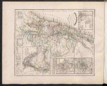
Palastina. Das Libanon-Gebiet.
1 : 1200000 Petermann, A.
Palaestina.
1 : 1220000 Radefeld, Carl Christian Franz, 1788-1874
La Terre Sainte sous Salomon.
1 : 2800000 Houze, Antoine Philippe
Palestine ancienne & moderne d'après les sources les plus authentiques
1 : 600000 Andriveau-Goujon, E. (Eugène), 1832-1897 E. Andriveau-Goujon