Maps of Alps

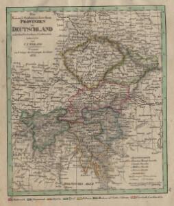
Die Kaiserl. Oesterreichischen Provinzen in Deutschland nebst dem Fürstenthume Liechtenstein
Österreich
SO Deutschland, Oesterreich. Lande.
1 : 5500000 Brudin, J. L.; Stieler, Adolf
[Habsburská monarchie]
1 : 4440000 Evropa jihovýchodní
[Habsburská monarchie]
1 : 4440000 Evropa jihovýchodní
Deutsch-Oesterreichische Länder
1 : 5000000 Österreich
States of the Late Germanic Confederation.
1 : 2344320 Fullarton, A. & Co.


Süd-Östliches Deutschland, enthält die Oesterreichischen Lande
Schul-Atlas über alle Theile der Erde nach dem neuesten Zustande, und über das Weltgebäude Stieler, Adolf bei Justus Perthes

Ungarn mit seinen Nebenländern und Galizien
1 : 1600000 Kiepert, Heinrich, 1818-1899 geografisches Institut
Ungarn, Galizien.
1 : 1600000 Kiepert, Heinrich, 1818-1899
Carte du Théâtre de la Guerre en Allemagne, en Autriche et en Italie; où se trouvent tracés les Marches, Positions, Batailles et Combats, de la Grande-Armée, commandée en personne par S. M. l'Empereur Napoléon; pendant la Campgane de 1805, et ceux de l'Armée d'Italie, commandée par S. Ex. le Maréchal Masséna
Picquet, Charles; Magimel, Denis-Simon
S. R. I. circvlvs Avstriacvs quem componunt archid. Avstriae, dvcatvs Stiriae, Carinthiae, Carnioliae, comit. Tyrolensis, ditionesque Sveviae austriacae, cum suis confiniis
1 : 1730000 Korutansko (Rakousko) Mayer, Tobias curantibus Homannianis Heredibus
S. R. I. Circulus Austriacus quem componunt Archid. Austriae, Ducatus Stiriae, Carinthiae, Carnioliae, Comit. Tyrolensis, ditionesque Sueviae austriacae, cum suis confiniis
1 : 1800000 Mayer, Tobias
Übersichts-Karte der Weinbau-Gebiete Österreich's
1 : 800000 Rakousko-Uhersko k. u. k. milit.-geographisches Institut
S. R. I. Circvlvs Avstriacvs
1 : 1800000 Mollova mapová sbírka Mayer, Tobias Homann, Johann Baptista - dědici
Austria & Hungary (western sheet).
1 : 1642000 Johnston, W. & A.K.
[Süd-Östliches Deutschland]
Schul-Atlas über alle Theile der Erde nach dem neuesten Zustande, und über das Weltgebäude Stieler, Adolf Justus Perthes
Übersichtskarte für die Operationen der k. k. Nordarmee im Jahre 1866
1 : 1900000 Evropa střední Ditfurth, Moritz von des K. u. k. Militärgeographischen Instituts
The South East Part of Germany
1 : 3500000 Mollova mapová sbírka Moll, Herman Moll, Hermann
[Rakousko]
1 : 2115000 Evropa střední
Völker-, Telegrafen- und Eisenbahn- Karte des Kaiserthumes Österreich
1 : 2500000 Chorvatsko Raffelsperger, Franz Kunst-Anstalt
The south east part of Germany.
1 : 3500000 Moll, Herman, d. 1732
Austro-Hungarian Monarchy (western sheet).
1 : 1642000 Johnston, Alexander Keith
Süddeutsche Bundesstaaten
Evropa střední
Süddeutsche Bundesstaaten
Evropa střední
Süddeutsche Bundesstaaten
Evropa střední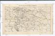
Weltverkehrslinien Oesterreich-Ungarn's und deren Lücken
1 : 2371000 Rakousko-Uhersko