Maps of Austria

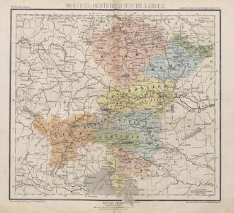
Deutsch-Oesterreichische Länder
1 : 5000000 Österreich

S. R. I. Circulus Austriacus quem componunt Archid. Austriae, Ducatus Stiriae, Carinthiae, Carnioliae, Comit. Tyrolensis, ditionesque Sueviae austriacae, cum suis confiniis
1 : 1800000 Mayer, Tobias
S. R. I. circvlvs Avstriacvs quem componunt archid. Avstriae, dvcatvs Stiriae, Carinthiae, Carnioliae, comit. Tyrolensis, ditionesque Sveviae austriacae, cum suis confiniis
1 : 1730000 Korutansko (Rakousko) Mayer, Tobias curantibus Homannianis Heredibus
S. R. I. Circvlvs Avstriacvs
1 : 1800000 Mollova mapová sbírka Mayer, Tobias Homann, Johann Baptista - dědici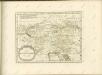

Süd-Östliches Deutschland, enthält die Oesterreichischen Lande
Schul-Atlas über alle Theile der Erde nach dem neuesten Zustande, und über das Weltgebäude Stieler, Adolf bei Justus Perthes

Die Kaiserl. Oesterreichischen Provinzen in Deutschland nebst dem Fürstenthume Liechtenstein
Österreich
Nieuwe kaart van de Beyersche en Oostenryksche Kreits
1 : 2000000 Annotatie: Uit: Nieuwe Hand-Atlas. - Amsterdam : Tirion, 1744 Te Amsterdam : by Isaak Tirion
SO Deutschland, Oesterreich. Lande.
1 : 5500000 Brudin, J. L.; Stieler, Adolf
[Süd-Östliches Deutschland]
Schul-Atlas über alle Theile der Erde nach dem neuesten Zustande, und über das Weltgebäude Stieler, Adolf Justus Perthes
[Rakousko]
1 : 2115000 Evropa střední
The South East Part of Germany
1 : 3500000 Mollova mapová sbírka Moll, Herman Moll, Hermann
Mapa Rakouska
1 : 2000000
Süddeutsche Bundesstaaten
Evropa střední
Süddeutsche Bundesstaaten
Evropa střední
Süddeutsche Bundesstaaten
Evropa střední
Austria & Hungary (western sheet).
1 : 1642000 Johnston, W. & A.K.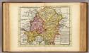
The south east part of Germany.
1 : 3500000 Moll, Herman, d. 1732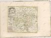

Ungarn mit seinen Nebenländern und Galizien
1 : 1600000 Kiepert, Heinrich, 1818-1899 geografisches Institut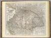
Ungarn, Galizien.
1 : 1600000 Kiepert, Heinrich, 1818-1899
Süd Deutschland und die Alpenlaender
[Allgemeiner Atlas über alle Theile der Erde in 29 Blättern] Ziegler, Jakob Melchior Top. Anstalt v. J. Wurster u. Comp.
Austro-Hungarian Monarchy (western sheet).
1 : 1642000 Johnston, Alexander Keith
Austro-Hungarian Monarchy (western sheet).
1 : 1642000 Johnston, Alexander Keith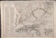
Carte du Théâtre de la Guerre en Allemagne, en Autriche et en Italie; où se trouvent tracés les Marches, Positions, Batailles et Combats, de la Grande-Armée, commandée en personne par S. M. l'Empereur Napoléon; pendant la Campgane de 1805, et ceux de l'Armée d'Italie, commandée par S. Ex. le Maréchal Masséna
Picquet, Charles; Magimel, Denis-Simon
Austria W.
1 : 1642000 Johnston, Alexander Keith, 1804-1871
Republik Österreich
1 : 2000000 Rakousko R. Lechner (Wilh. Müller)