Maps of Alps

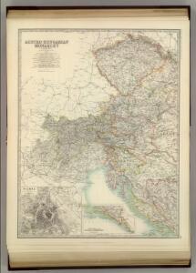
Austro-Hungarian Monarchy (western sheet).
1 : 1642000 Johnston, Alexander Keith
Austria & Hungary (western sheet).
1 : 1642000 Johnston, W. & A.K.
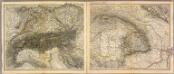
Alpen- u. Donaulaender.
1 : 1900000 Stein, Christ. Gottfr. Dan.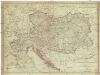
Karte der oesterreichischen Monarchie und der vor osterreichischen Prinzen und Prinzessinen beherrschten italienischen Staaten als Toscana, Modena, Parma und Massa nach dem Wiener Congresse den späteren Verträgen und Gränzbestimmungen
1 : 2000000 Evropa jihovýchodní Fried, Franz Reißer, Franz Artaria
Carte des confins de la France et des principales postes, de Paris aux païs estrangers
1 Karte : Kupferdruck ; 43 x 44 cm Placide de Sainte Hélène; Duval chez M.elle Du-Ual sur le quay de l'orloge prés le coin de la rüe de Harlay a l'ancien buïs
Carte Generale l'Empire d'Autriche.
1 : 2700000 Vivien de St Martin, L.
Danubii fluminis (â fontibus prope Doneschingam usq. Posonium urbem designati) pars superior
1 : 1982000 Bavorsko (Německo) Homann, Johann Baptist Ioh. Bapt. Homano
Carta Noua accurata del Paßagio et strada dalli Paesi Baßi per via de Allemagna per Italia et per via di Paesi svizeri à Geneua, Lione et Roma
1 : 2100000 Mollova mapová sbírka Danckertsz, Cornelis Danckerts, Cornelis I.
Carta Noua accurata del Paßagio et strada dalli Paesi Baßi per via de Allemagna per Italia et per via di Paesi svizeri à Geneua, Lione et Roma
1 : 2100000 Mollova mapová sbírka Danckerts, Cornelis Danckerts, Cornelis I.
Austria W.
1 : 1642000 Johnston, Alexander Keith, 1804-1871
Alps. Pergamon World Atlas.
1 : 2500000 Polish Army Topography Service
Danubii fluminis (à fontibus prope Doneschingam usq[ue] Posonium urbem designati) pars superior
1 Karte : Kupferdruck ; 46 x 54 cm Homann Johann Baptist Homann
Danubii fluminis (à fontibus prope Doneschingam usq[ue] Posonium urbem designati) pars superior
1 Karte : Kupferdruck ; 46 x 54 cm Homann Johann Baptist Homann
Alpenland
E. von Sydow's Schul-Atlas in sechs und dreissig Karten Sydow, Emil von bei Justus Perthes
Austro-Hungarian Monarchy (western sheet).
1 : 1642000 Johnston, Alexander Keith
Süddeutsche Bundesstaaten
Evropa střední
Süddeutsche Bundesstaaten
Evropa střední
Süddeutsche Bundesstaaten
Evropa střední
Carta delle Alpi / dir. G. Garollo ; Francesco Vallardi
1 : 2500000 G. Garollo Francesco Vallardi
Exactissima Tabula, qua tam Danubii Fluvii Pars Superior
1 : 2100000 Mollova mapová sbírka Visscher, Nicolaes Jansz. Visscher, Nicolaus
Exactissima Tabula, qua tam Danubii Fluvii Pars Superior
1 : 2100000 Mollova mapová sbírka Visscher, Nicolaes Jansz. Visscher, Nicolaus
Italien
Itálie severní
Alpenlander.
1 : 1250000 Berghaus, Hermann
Alpy

Charte von Deutschland
Evropa střední Berra, Marco Marco Berra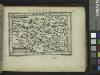
Austria.
from Abraham Ortelius his epitome of the theater of the worlde / nowe latlye ... renewed and augmented ... by Micheal Coignet, mathematitian of Antwarpe.
Mapa Rakouska
1 : 2000000