Maps of North Region

[145][148] Terra Nova ... Terra Neuf ..., uit: Atlas sive Descriptio terrarum orbis
Annotatie: Gedigitaliseerde versie. Amsterdam. Heiloo : Picturae (vervaardiger), 2015. tiff-bestand. Gedigitaliseerd: 07-01-2015; Origineel: Universiteitsbibliotheek Vrije Universiteit (XL.05127.-) ; Netherlands; Titelpagina ontbreekt Wit, Frederik de Amsterdam : Frederick de Wit
Pascaerte vande Vlaemsche, Soute, en Caribesche Eylanden, als mede Terra Nova, en de custen van Nova Francia, Nova Anglia, Nieu Nederlandt, Venezuela, Nueva Andalusia, Giuana, en een gedeelte van Brazil / Abraham Deur fecit
1 : 13500000 Annotatie: Uit: De zee-atlas, ofte water-weereld ... - Amsterdam : Pieter Goos, 1666 [Amsterdam : Pieter Goos]
Pascaerte vande Vlaemsche, Soute, en Caribesche Eylanden, als mede Terra Nova, en de custen van Nova Francia, Nova Anglia, Nieu Nederlandt, Venezuela, Nueva Andalusia, Guiana en een gedeelte van Brazil.
from De zee-atlas, ofte, Water-weereld : waer in vertoont werden alle de zee-kusten van het bekende des aerd-bodems : seer dienstigh voor alle heeren en kooplieden, als oock voor alle schippers en stuurlieden / gesneden, gedruckt en uytgegeven t'Amsteldam.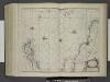
Pascaerte van Vlaemsche, Soute, en Caribesche Eylanden, als mede Terra Nova, en de Custen van Nova Francia, Nova Anglia, Nieu Nederlandt, Venezuela, Nueva Andalusia, Guiana, en een gedeelte van Brazil.
from De zee-atlas ofte water-wereld : waer in vertoont werden alle de zee-kusten van het bekende des aerd-bodems : seer dienstigh voor alle heeren en kooplieden, als oock voor alle schippers en stuurlieden / by Pieter Goos.
Terra nova, ac maris tractus circa Novam Franciam, Angliam, Belgium, Venezuelam Novam, Andalusiam, Guianan, et Brasiliam ; Terra neuf, en de custen van Nieu Vranckryck, Nieu Engeland, Nieu Nederland, Nieu Andalusia, Guiana en Venezuela
1 : 12521000
Pascaerte van Brazil en Nieu Nederlandt can Cuorvo en Flores tot de Barbados [Karte], in: De Nieuwe Groote Vermeerderde Zee-Atlas ofte Water-Werelt, S. 63.
1 Karte aus Atlas Doncker, Hendrick
Pascaerte van Brazil en Niev Nederlandt
1 Karte : Kupferdruck ; 43 x 54 cm Doncker by Hendrick Doncker inde Nieubrugh steegh int Stuurmans gereeschap
Pascaerte vande Vlaemsche, Soute, en Caribesche Eylanden, als mede Terra Nova, en de custen van Nova Francia, Nova Anglia, Nieu Nederlandt, Venezuela, Nueva Andalusia, Guiana en een gedeelte van Brazil
1 : 13000000
Pascaerte van 't westelyckste deel vande Spaense Zee, tuschen Brasil, de zoute en Vlaemse eylanded, en voorwestwart
1 : 7000000
Terra Nova, ac maris tractus circa Novam Franciam, Angliam, Belgium, Venezuelam Novam Andalusiam, Guianam, et Brasiliam
1 Karte : Kupferdruck ; 47 x 56 cm Renard gedruckt by L. Renard
Chart shewing the tracks across the North Atlantic Ocean, of Don Christopher Columbus / eng'd by W. Kemble.
from Atlantic Ocean W. Kemble,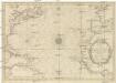
CARTE DE L'OCEAN OCCIDENTAL
1 : 6600000 Atlantský oceán-oblast Bellin, Jacques-Nicolas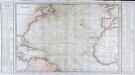
Carte générale de l'océan Atlantique ou Occidental
1 Karte : Kupferdruck ; 59 x 88 cm s.n.
Tableau des courants observés dans l'Océan Atlantique Septentrional, au moyen de bouteilles jetées à la mer. / dressé par P. Daussy, ingénieur hydrographe en chef de la Marine; gravé par Michel; écrit par J.M. Hacq.
from Atlantic Ocean P. Daussy; Michel; J.M. Hacq.,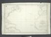
Carta general del Oceano Atlantico ú ocidental desde 52o de latitud norte hasta el Equador / construida de orden del Rey en el Deposito Hidrografico de Marina y presentada á S.M. por mano del Exmo. Señor D. Antonio Cornel, Secretario de Estado y del Despacho Universal de Guerra, Encargado del de Marina y de la Direccion General de la Real Armada.
from Atlantic Ocean D. Antonio Cornel,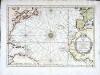
Carte de l'ocean occidental
1 Karte : Kupferdruck ; 31 x 44 cm Bellin Arkstée et Merkus
Chart of the Atlantic Ocean: with an illustration of the character and rout[e] of a storm which occurred on the American coast in August 1830 / William Hooker, engraver, New York.
from Atlantic Ocean William Hooker,
Nieuwe wassende graade zee kaart over de Spaanse Zee vant kanaal tot t'eyland Cuba in Westindia = Nouvelle carte marine reduite de la Mer d. Espagne du canal jusqua Terra Neuf en I. de Cuba dans l'Amerique = The new sea map of the Spannish Zee betwext t' chanell and the I. Cuba / L.v. Anse, schulp.
from Charts and maps L.v. Anse; I. Cuba,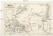
Plavby Krištofa [sic] Kolumba
Atlantský oceán-oblast
A new chart of the vast Atlantic Ocean: exhibiting the seat of war, both in Europe and America, likewise the trade winds & course of sailing from one continent to the other, with the banks, shoals and rocks drawn according to the latest discoveries, and regulated by astronomical observations / Emanl. Bowen, sculp.
from Atlantic Ocean Emannuel Bowen,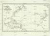
Chart shewing the tracks across the north Atlantic ocean of don Christopher Columbus
Atlantský oceán Toquet, H. Raban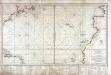
Carte réduite d'une partie de l'ocean Atlantique ou Occidental
1 Karte : Kupferdruck ; 46 x 81 cm Verdun de la Crenne; Borda; Pingré; Petit; Claret de Fleurieu s.n.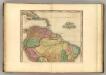
South America (northern half).
1 : 10200000 Tanner, Henry S.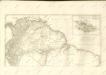
South America north.
1 : 10500000 Cary, John, ca. 1754-1835
A map of Caracas.
from Carey's general atlas, improved and enlarged : being a collection of maps of the world and quarters, their principal empires, kingdoms, &c.
Facsimile: Part of South America by De Vaugondy.
1 : 12600000 de Vaugondy, Robert
Sudamerika nordliches Blatt.
1 : 20000000 Andree, Richard
Sud-America in zwei Blattern.
1 : 14000000 Stulpnagel, F.v.
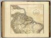
South America and West Indies.
1 : 10500000 Tanner, Henry S.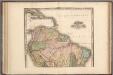
South America and West Indies.
1 : 10500000 Tanner, Henry S.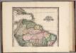
![[145][148] Terra Nova ... Terra Neuf ..., uit: Atlas sive Descriptio terrarum orbis](https://images-2.georeferencer.com/images/iiif/897755632183/full/,300/0/native.jpg)

