Maps of Amazon Basin
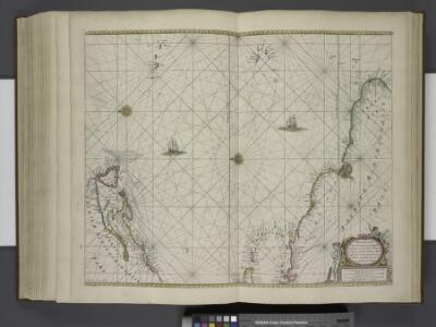
Pascaerte van Vlaemsche, Soute, en Caribesche Eylanden, als mede Terra Nova, en de Custen van Nova Francia, Nova Anglia, Nieu Nederlandt, Venezuela, Nueva Andalusia, Guiana, en een gedeelte van Brazil.
from De zee-atlas ofte water-wereld : waer in vertoont werden alle de zee-kusten van het bekende des aerd-bodems : seer dienstigh voor alle heeren en kooplieden, als oock voor alle schippers en stuurlieden / by Pieter Goos.
Pascaerte vande Vlaemsche, Soute, en Caribesche Eylanden, als mede Terra Nova, en de custen van Nova Francia, Nova Anglia, Nieu Nederlandt, Venezuela, Nueva Andalusia, Giuana, en een gedeelte van Brazil / Abraham Deur fecit
1 : 13500000 Annotatie: Uit: De zee-atlas, ofte water-weereld ... - Amsterdam : Pieter Goos, 1666 [Amsterdam : Pieter Goos]
Chart of the Atlantic Ocean.
1 : 35000000 Melish, John
[145][148] Terra Nova ... Terra Neuf ..., uit: Atlas sive Descriptio terrarum orbis
Annotatie: Gedigitaliseerde versie. Amsterdam. Heiloo : Picturae (vervaardiger), 2015. tiff-bestand. Gedigitaliseerd: 07-01-2015; Origineel: Universiteitsbibliotheek Vrije Universiteit (XL.05127.-) ; Netherlands; Titelpagina ontbreekt Wit, Frederik de Amsterdam : Frederick de Wit
Pascaerte van Brazil en Nieu Nederlandt can Cuorvo en Flores tot de Barbados [Karte], in: De Nieuwe Groote Vermeerderde Zee-Atlas ofte Water-Werelt, S. 63.
1 Karte aus Atlas Doncker, Hendrick
Pascaerte vande Vlaemsche, Soute, en Caribesche Eylanden, als mede Terra Nova, en de custen van Nova Francia, Nova Anglia, Nieu Nederlandt, Venezuela, Nueva Andalusia, Guiana en een gedeelte van Brazil.
from De zee-atlas, ofte, Water-weereld : waer in vertoont werden alle de zee-kusten van het bekende des aerd-bodems : seer dienstigh voor alle heeren en kooplieden, als oock voor alle schippers en stuurlieden / gesneden, gedruckt en uytgegeven t'Amsteldam.
The Western Ilands / by Rt. Morden.
from Geography rectified, or, A description of the world : in all its kingdoms, provinces, countries, islands, cities, towns, seas, rivers, bayes, capes, ports : their antient and present names, inhabitants, situations, histories, customs, governments, &c. : as also their commodities, coins, weights, and measures, compared with those at London : illustrated with above sixty new maps : the whole work performed according to the more accurate discoveries of modern authors / by Robert Morden.
Terra nova, ac maris tractus circa Novam Franciam, Angliam, Belgium, Venezuelam Novam, Andalusiam, Guianan, et Brasiliam ; Terra neuf, en de custen van Nieu Vranckryck, Nieu Engeland, Nieu Nederland, Nieu Andalusia, Guiana en Venezuela
1 : 12521000
Pascaerte van Brazil en Niev Nederlandt
1 Karte : Kupferdruck ; 43 x 54 cm Doncker by Hendrick Doncker inde Nieubrugh steegh int Stuurmans gereeschap
North Atlantic Ocean.
1 : 19000000 Johnston, W. & A.K.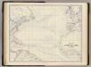
N. Atlantic Ocean.
1 : 19000000 Johnston, Alexander Keith, 1804-1871
XI. Basin of the North Atlantic Ocean
Maury, Matthew Fontaine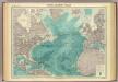
North Atlantic Ocean.
1 : 25000000 John Bartholomew & Co.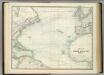
North Atlantic Ocean.
1 : 17500000 Johnston, Alexander Keith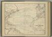
North Atlantic Ocean.
1 : 17500000 Johnston, Alexander Keith
VI. Gulf stream and drift
Maury, Matthew Fontaine
Carte marine de l'Amerique septentrionale et une partie de la B.e d'Hudson
1 Karte : Kupferdruck ; 41 x 48 cm Königliche Akademie der Wissenschaften
Chart of the Atlantic Ocean.
1 : 43000000 Melish, John
X. August and September Hurricane of 1848
Maury, Matthew Fontaine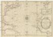
CARTE DE L'OCEAN OCCIDENTAL
1 : 6600000 Atlantský oceán-oblast Bellin, Jacques-Nicolas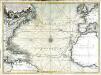
Nouvelle carte de l'ocean Atlantique et théatre de la guerre tant en Europe qu'en Amerique
1 Karte : Kupferdruck ; 52 x 71 cm Denis; Basset; Basset chés Basset rüe St. Jacques au coin de celle des Mathurins à l'image S.te Genevieve
Chart shewing the tracks across the North Atlantic Ocean, of Don Christopher Columbus / eng'd by W. Kemble.
from Atlantic Ocean W. Kemble,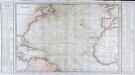
Carte générale de l'océan Atlantique ou Occidental
1 Karte : Kupferdruck ; 59 x 88 cm s.n.
Tableau des courants observés dans l'Océan Atlantique Septentrional, au moyen de bouteilles jetées à la mer. / dressé par P. Daussy, ingénieur hydrographe en chef de la Marine; gravé par Michel; écrit par J.M. Hacq.
from Atlantic Ocean P. Daussy; Michel; J.M. Hacq.,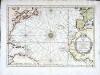
Carte de l'ocean occidental
1 Karte : Kupferdruck ; 31 x 44 cm Bellin Arkstée et Merkus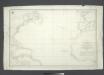
Carta general del Oceano Atlantico ú ocidental desde 52o de latitud norte hasta el Equador / construida de orden del Rey en el Deposito Hidrografico de Marina y presentada á S.M. por mano del Exmo. Señor D. Antonio Cornel, Secretario de Estado y del Despacho Universal de Guerra, Encargado del de Marina y de la Direccion General de la Real Armada.
from Atlantic Ocean D. Antonio Cornel,
Terra Nova, ac maris tractus circa Novam Franciam, Angliam, Belgium, Venezuelam Novam Andalusiam, Guianam, et Brasiliam
1 Karte : Kupferdruck ; 47 x 56 cm Renard gedruckt by L. Renard
Pascaerte vande Vlaemsche, Soute, en Caribesche Eylanden, als mede Terra Nova, en de custen van Nova Francia, Nova Anglia, Nieu Nederlandt, Venezuela, Nueva Andalusia, Guiana en een gedeelte van Brazil
1 : 13000000
Pascaerte van 't westelyckste deel vande Spaense Zee, tuschen Brasil, de zoute en Vlaemse eylanded, en voorwestwart
1 : 7000000