Maps of Guiana Shield

Pascaerte van Brazil en Niev Nederlandt
1 Karte : Kupferdruck ; 43 x 54 cm Doncker by Hendrick Doncker inde Nieubrugh steegh int Stuurmans gereeschap
[145][148] Terra Nova ... Terra Neuf ..., uit: Atlas sive Descriptio terrarum orbis
Annotatie: Gedigitaliseerde versie. Amsterdam. Heiloo : Picturae (vervaardiger), 2015. tiff-bestand. Gedigitaliseerd: 07-01-2015; Origineel: Universiteitsbibliotheek Vrije Universiteit (XL.05127.-) ; Netherlands; Titelpagina ontbreekt Wit, Frederik de Amsterdam : Frederick de Wit
Pascaerte van Brazil en Nieu Nederlandt can Cuorvo en Flores tot de Barbados [Karte], in: De Nieuwe Groote Vermeerderde Zee-Atlas ofte Water-Werelt, S. 63.
1 Karte aus Atlas Doncker, Hendrick
Pascaerte van 't westelyckste deel vande Spaense Zee, tuschen Brasil, de zoute en Vlaemse eylanded, en voorwestwart
1 : 7000000
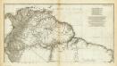
Pascaerte vande Vlaemsche, Soute, en Caribesche Eylanden, als mede Terra Nova, en de custen van Nova Francia, Nova Anglia, Nieu Nederlandt, Venezuela, Nueva Andalusia, Giuana, en een gedeelte van Brazil / Abraham Deur fecit
1 : 13500000 Annotatie: Uit: De zee-atlas, ofte water-weereld ... - Amsterdam : Pieter Goos, 1666 [Amsterdam : Pieter Goos]
Terra Nova, ac maris tractus circa Novam Franciam, Angliam, Belgium, Venezuelam Novam Andalusiam, Guianam, et Brasiliam
1 Karte : Kupferdruck ; 47 x 56 cm Renard gedruckt by L. Renard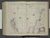
Pascaerte van Vlaemsche, Soute, en Caribesche Eylanden, als mede Terra Nova, en de Custen van Nova Francia, Nova Anglia, Nieu Nederlandt, Venezuela, Nueva Andalusia, Guiana, en een gedeelte van Brazil.
from De zee-atlas ofte water-wereld : waer in vertoont werden alle de zee-kusten van het bekende des aerd-bodems : seer dienstigh voor alle heeren en kooplieden, als oock voor alle schippers en stuurlieden / by Pieter Goos.
Pascaerte vande Vlaemsche, Soute, en Caribesche Eylanden, als mede Terra Nova, en de custen van Nova Francia, Nova Anglia, Nieu Nederlandt, Venezuela, Nueva Andalusia, Guiana en een gedeelte van Brazil.
from De zee-atlas, ofte, Water-weereld : waer in vertoont werden alle de zee-kusten van het bekende des aerd-bodems : seer dienstigh voor alle heeren en kooplieden, als oock voor alle schippers en stuurlieden / gesneden, gedruckt en uytgegeven t'Amsteldam.
Terra nova, ac maris tractus circa Novam Franciam, Angliam, Belgium, Venezuelam Novam, Andalusiam, Guianan, et Brasiliam ; Terra neuf, en de custen van Nieu Vranckryck, Nieu Engeland, Nieu Nederland, Nieu Andalusia, Guiana en Venezuela
1 : 12521000
Pascaerte vande Vlaemsche, Soute, en Caribesche Eylanden, als mede Terra Nova, en de custen van Nova Francia, Nova Anglia, Nieu Nederlandt, Venezuela, Nueva Andalusia, Guiana en een gedeelte van Brazil
1 : 13000000
A new chart of the vast Atlantic Ocean: exhibiting the seat of war, both in Europe and America, likewise the trade winds & course of sailing from one continent to the other, with the banks, shoals and rocks drawn according to the latest discoveries, and regulated by astronomical observations / Emanl. Bowen, sculp.
from Atlantic Ocean Emannuel Bowen,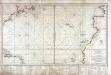
Carte réduite d'une partie de l'ocean Atlantique ou Occidental
1 Karte : Kupferdruck ; 46 x 81 cm Verdun de la Crenne; Borda; Pingré; Petit; Claret de Fleurieu s.n.
Portugal.
From [Series of advertising cards issued by Arbuckle Bros. Coffee Company, each consisting of a map of a country of the world with related illustrations.]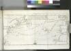
[Map of the North Atlantic Ocean to accompany Jonathan Williams' article on the use of the thermometer in discovering banks, soundings, etc..]; Transactions of the American Philosophical Society.
from Transactions of the American Philosophical Society. American Philosophical Society,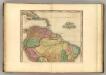
South America (northern half).
1 : 10200000 Tanner, Henry S.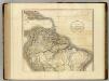
South America north.
1 : 10500000 Cary, John, ca. 1754-1835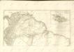

Ice Chart, Grand Banks Region, July.
U.S. Navy
Terra Firma and the Caribbé Islands &c.
1 : 20000000
Ice Chart, Grand Banks Region, October.
U.S. Navy
A map of Caracas.
from Carey's general atlas, improved and enlarged : being a collection of maps of the world and quarters, their principal empires, kingdoms, &c.
Tierra nveva.
from Charts and maps Sesssa?: [Venice]; Ruscelli, Girolamo; Gastaldi, Giacomo,
Depths and temperatures observed in the western part of the North Atlantic Ocean
1 : 7000000 United States Coast Survey U.S. Coast Survey
Africa.
1 : 40000000 Cornell, S. S. (Sarah S.)
Facsimile: Part of South America by De Vaugondy.
1 : 12600000 de Vaugondy, Robert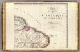
Amerique Meridionale 2.
1 : 6400000 Brue, Adrien Hubert, 1786-1832
Sud-America in zwei Blattern.
1 : 14000000 Stulpnagel, F.v.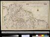
Zuid-Amerika ten noorden van 10° Z.B.
South-America Gerard van Keulen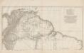
Amerique Meridionale [a]
1 : 6300000 Parte superior del más importante y detallado mapa francés sobre Suramérica de mediados del siglo XVIII, elaborado por Jean Baptiste Bourguignon D’Anville, una de las autoridades cartográficas más trascendentales de su tiempo. Tal y como informa en el cartucho [hoja inferior del mapa] la parte norte de Suramérica se basa información colectada por Charles-Marie de La Condamine durante su viaje por el amazonas, y durante la Expedición Geodésica al Virreinato de Perú, encargada de medir la forma de la Tierra en el Ecuador. También toma información de Pierre Bouguer, otro de los miembros de la Expedición Geodésica al Virreinato de Perú, y de Pedro Vicente de Maldonado, científico ecuatoriano colaborador de la Expedición, y famoso por su mapa Carta de la Provincia de Quito y de sus adjacentes de 1750. Anville, Jean Baptiste Bourguignon d' (1697-1782) Delahaye, Guillaume-Nicolas (1727-1802)