Maps of West Indies

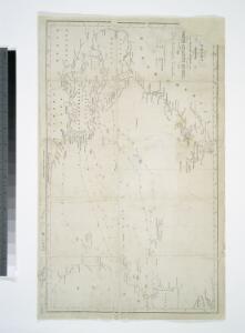
Chart shewing the tracks across the North Atlantic Ocean, of Don Christopher Columbus / eng'd by W. Kemble.
from Atlantic Ocean W. Kemble,
VI. Gulf stream and drift
Maury, Matthew Fontaine
XI. Basin of the North Atlantic Ocean
Maury, Matthew Fontaine
Nord-Atlantischer Ocean
Hand-Atlas über alle Theile der Erde und über das Weltgebäude Stieler, Adolf Justus Perthes
Nord-Atlantischer Ocean
Handatlas über alle Theile der Erde und über das Weltgebäude Stieler, Adolf Justus Perthes
Monatskarte für den Nordatlantischen Ozean
1 : 10700000 Atlantský oceán (oblast) Eckardt & Messtorff
Pilot chart of the North Atlantic Ocean
1 : 14300000 Atlantský oceán (oblast) Maury, Matthew Fontaine Hydrographic Office
Pilot chart of the North Atlantic Ocean
1 : 14300000 Atlantský oceán (oblast) Maury, Matthew Fontaine Hydrographic Office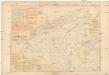
Pilot chart of the North Atlantic Ocean
1 : 14300000 Atlantský oceán (oblast) Maury, Matthew Fontaine Hydrographic Office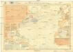
Pilot chart of the North Atlantic Ocean
1 : 11300000 Atlantský oceán (oblast) Hydrographic Office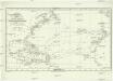
Chart shewing the tracks across the north Atlantic ocean of don Christopher Columbus
Atlantský oceán Toquet, H. Raban
Chart of the Atlantic Ocean: with an illustration of the character and rout[e] of a storm which occurred on the American coast in August 1830 / William Hooker, engraver, New York.
from Atlantic Ocean William Hooker,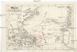
Plavby Krištofa [sic] Kolumba
Atlantský oceán-oblast
Meteorological chart of the North Atlantic Ocean
1 : 13700000 Atlantský oceán (oblast) Secretary of Agriculture
Meteorological chart of the North Atlantic Ocean
1 : 13700000 Atlantský oceán (oblast) Secretary of Agriculture
Mar del Nort / [Joannes Janssonius]
1 : 30000000 Annotatie: Origineel is Blad 3 in atlas factice Janssonius, Joannes (jr.) (1588-1664) [Amsterdam : Joannes Janssonius]
A new map or chart in Mercators projection, of the Western or Atlantic Ocean, with part of Europe, Africa and America
1 : 18000000
Mar Del Nort. [Karte], in: Het vijfde Deel Des Grooten Atlas : Vervatende De Water-Weereld, S. 56.
1 Karte aus Atlas Jansson, Jan Jansson, Jan
Chart of the Atlantic Ocean.
from The new American practical navigator; : being an epitome of navigation; containing all the tables necessary to be used with the Nautical Almanac, in determining the latitude; and the longitude by lunar observations; and keeping a complete reckoning at sea. ... : The whole exemplified in a journal, kept from Boston to Madeira, in which all the rules of navigation are introduced ... : To which are added, some general instructions and information ... relative to maritime laws and mercantile customs. / From the best authorities. ; enriched with a number of new tables, with original improvements and additions, and a large variety of new and important matter: also many thousand errors are corrected, which have appeared in the best systems of navigation yet published. ; By Nathaniel Bowditch, Fellow of the American Academy of Arts and Sciences. ; Illustrated with copperplates.
Mar Del Nort. [Karte], in: Novus atlas absolutissimus, Bd. 9, S. 58.
1 Karte aus Atlas Janssonius Offizin
A new map or chart in Mercators projection of the Western or Atlantic Ocean: with part of Europe, Africa and America.
from Atlantic Ocean J. (John) Bew?: [London],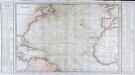
Carte générale de l'océan Atlantique ou Occidental
1 Karte : Kupferdruck ; 59 x 88 cm s.n.
Tableau des courants observés dans l'Océan Atlantique Septentrional, au moyen de bouteilles jetées à la mer. / dressé par P. Daussy, ingénieur hydrographe en chef de la Marine; gravé par Michel; écrit par J.M. Hacq.
from Atlantic Ocean P. Daussy; Michel; J.M. Hacq.,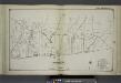
Part of Brookhaven Suffolk County
from Atlas of ... Suffolk County, Long Island, New York ... : based upon actual measurements by our own corps of engineers, maps on file at county offices, also maps from actual surveys furnished by individual owners / under the supervision of Merritt B. Hyde.
A Chart of the Atlantic or Western Ocean : laid down from the latest discoveries and regulated by numerous astronomical observations.
from Atlantic Ocean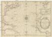
CARTE DE L'OCEAN OCCIDENTAL
1 : 6600000 Atlantský oceán-oblast Bellin, Jacques-Nicolas
Chart of the Atlantic Ocean.
1 : 35000000 Melish, John
Mar del nort
1 : 30000000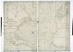
A chart of the Atlantic or Western Ocean / drawn from the latest surveys & astronomical observations by J. & A. Walker, London & Liverpool 1830.
from Atlantic Ocean J. & A. Walker,