Maps of North Atlantic Ocean
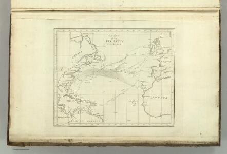
Chart of the Atlantic Ocean.
1 : 35000000 Melish, John
Der Atlantische Ocean
Hand-Atlas über alle Theile der Erde nach dem neuesten Zustande und über das Weltgebäude Stieler, Adolf bei Justus Perthes
Chart of the Atlantic Ocean.
from The new American practical navigator; : being an epitome of navigation; containing all the tables necessary to be used with the Nautical Almanac, in determining the latitude; and the longitude by lunar observations; and keeping a complete reckoning at sea. ... : The whole exemplified in a journal, kept from Boston to Madeira, in which all the rules of navigation are introduced ... : To which are added, some general instructions and information ... relative to maritime laws and mercantile customs. / From the best authorities. ; enriched with a number of new tables, with original improvements and additions, and a large variety of new and important matter: also many thousand errors are corrected, which have appeared in the best systems of navigation yet published. ; By Nathaniel Bowditch, Fellow of the American Academy of Arts and Sciences. ; Illustrated with copperplates.
Chart of the Atlantic Ocean, with the British, French, & Spanish settlements in North America and the West Indies : as also on the coast of Africa / by Thos. Jefferys, geographer to His Majesty.
from Atlantic Ocean
Die Luftstromungen auf dem Nordatlantishcen Ocean.
1 : 29000000 Berghaus, Heinrich
A new generall chart for the West Indies....
from English pilot. The fourth book.
Nord-Atlantischer Ocean
Hand-Atlas über alle Theile der Erde und über das Weltgebäude Stieler, Adolf Justus Perthes
A new chart of the vast Atlantic Ocean : exhibiting the seat of war, both in Europe and America, likewise the trade winds & course of sailing from one continent to the other, with the banks, shoals and rocks drawn according to the latest discoveries,
from John H. Levine Collection
Nord-Atlantischer Ocean
Handatlas über alle Theile der Erde und über das Weltgebäude Stieler, Adolf Justus Perthes
Meteorological chart of the North Atlantic Ocean
1 : 13700000 Atlantský oceán (oblast) Secretary of Agriculture
Meteorological chart of the North Atlantic Ocean
1 : 13700000 Atlantský oceán (oblast) Secretary of Agriculture
Mar Del Nort. [Karte], in: Het vijfde Deel Des Grooten Atlas : Vervatende De Water-Weereld, S. 56.
1 Karte aus Atlas Jansson, Jan Jansson, Jan
Mar Del Nort. [Karte], in: Novus atlas absolutissimus, Bd. 9, S. 58.
1 Karte aus Atlas Janssonius Offizin
Carte de l'ocean Atlantique
1 Karte : Kupferdruck ; 47 x 61 cm Jefferys; Le Rouge chez Le Rouge rue des g.ds Augustins
Carte de l'océan Atlantique
1 Karte : Kupferdruck ; 48 x 61 cm Lattré chéz Lattré graveur du roy rue St. Jacques la porte cochère vis avis la rue de la Parcheminerie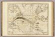
The Atlantic Ocean.
1 : 22500000 Pownall, Thomas
Atlantic Ocean.
1 : 45000000 Lizars, W. H. (William Home)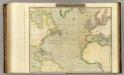
N. Atlantic Ocean.
1 : 22500000 Thomson, John
America [Karte], in: Gerardi Mercatoris Atlas, sive, Cosmographicae meditationes de fabrica mundi et fabricati figura, S. 547.
1 Karte aus Atlas Mercator, Gerhard Montanus, Petrus
Mar del Nort / [Joannes Janssonius]
1 : 30000000 Annotatie: Origineel is Blad 3 in atlas factice Janssonius, Joannes (jr.) (1588-1664) [Amsterdam : Joannes Janssonius]
Karte des Atlantischen Oceans
1 Karte : Kupferdruck ; 48 x 60 cm Schrämbl zu finden in eigenem Verlage Schrämbl
A Chart of the Atlantic or Western Ocean : laid down from the latest discoveries and regulated by numerous astronomical observations.
from Atlantic Ocean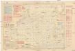
Pilot chart of the North Atlantic Ocean
1 : 14300000 Atlantský oceán (oblast) Maury, Matthew Fontaine Hydrographic Office
Pilot chart of the North Atlantic Ocean
1 : 14300000 Atlantský oceán (oblast) Maury, Matthew Fontaine Hydrographic Office
Pilot chart of the North Atlantic Ocean
1 : 14300000 Atlantský oceán (oblast) Maury, Matthew Fontaine Hydrographic Office
Pilot chart of the North Atlantic Ocean
1 : 11300000 Atlantský oceán (oblast) Hydrographic Office
General chart, of the North Atlantic, or Western Ocean, from the equator to 62° north latitude, according to the latest, surveys and observations
1 : 9000000
Mar del nort
1 : 30000000
North Atlantic Ocean.
1 : 8000000 Blunt, Edmund M. (Edmund March), 1770-1862