Maps of North Region

A Chart of the Atlantic or Western Ocean : laid down from the latest discoveries and regulated by numerous astronomical observations.
from Atlantic Ocean
Der Atlantische Ocean
Hand-Atlas über alle Theile der Erde nach dem neuesten Zustande und über das Weltgebäude Stieler, Adolf bei Justus Perthes
A new chart of the vast Atlantic Ocean : exhibiting the seat of war, both in Europe and America, likewise the trade winds & course of sailing from one continent to the other, with the banks, shoals and rocks drawn according to the latest discoveries,
from John H. Levine Collection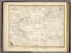
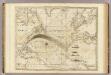
Die Luftstromungen auf dem Nordatlantishcen Ocean.
1 : 29000000 Berghaus, Heinrich
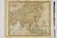
A new generall chart for the West Indies....
from English pilot. The fourth book.
Carte de l'ocean Atlantique
1 Karte : Kupferdruck ; 47 x 61 cm Jefferys; Le Rouge chez Le Rouge rue des g.ds Augustins
Carte de l'océan Atlantique
1 Karte : Kupferdruck ; 48 x 61 cm Lattré chéz Lattré graveur du roy rue St. Jacques la porte cochère vis avis la rue de la Parcheminerie
Meteorological chart of the North Atlantic Ocean
1 : 13700000 Atlantský oceán (oblast) Secretary of Agriculture
Meteorological chart of the North Atlantic Ocean
1 : 13700000 Atlantský oceán (oblast) Secretary of Agriculture
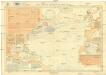
ASIA

ASIA
ASIA
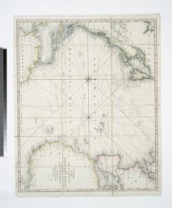
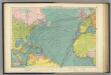
The Atlantic Ocean.
1 : 22500000 Pownall, Thomas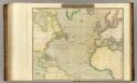
N. Atlantic Ocean.
1 : 22500000 Thomson, John
Karte des Atlantischen Oceans
1 Karte : Kupferdruck ; 48 x 60 cm Schrämbl zu finden in eigenem Verlage Schrämbl
Atlantic Ocean.
1 : 45000000 Lizars, W. H. (William Home)
Chart of the Atlantic Ocean.
from The new American practical navigator; : being an epitome of navigation; containing all the tables necessary to be used with the Nautical Almanac, in determining the latitude; and the longitude by lunar observations; and keeping a complete reckoning at sea. ... : The whole exemplified in a journal, kept from Boston to Madeira, in which all the rules of navigation are introduced ... : To which are added, some general instructions and information ... relative to maritime laws and mercantile customs. / From the best authorities. ; enriched with a number of new tables, with original improvements and additions, and a large variety of new and important matter: also many thousand errors are corrected, which have appeared in the best systems of navigation yet published. ; By Nathaniel Bowditch, Fellow of the American Academy of Arts and Sciences. ; Illustrated with copperplates.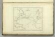
Chart of the Atlantic Ocean.
1 : 35000000 Melish, John
Chart of the Atlantic Ocean, with the British, French, & Spanish settlements in North America and the West Indies : as also on the coast of Africa / by Thos. Jefferys, geographer to His Majesty.
from Atlantic Ocean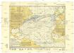
Monatskarte für den Nordatlantischen Ozean
1 : 10700000 Atlantský oceán (oblast) Eckardt & Messtorff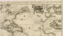
Carte tres curieuse de la mer du Sud, contenant des remarques nouvelles et tres utiles non seulement...
North Atlantic Ocean.
1 : 20000000 Philip, George
Mar Del Nort. [Karte], in: Het vijfde Deel Des Grooten Atlas : Vervatende De Water-Weereld, S. 56.
1 Karte aus Atlas Jansson, Jan Jansson, Jan
Mar del Nort / [Joannes Janssonius]
1 : 30000000 Annotatie: Origineel is Blad 3 in atlas factice Janssonius, Joannes (jr.) (1588-1664) [Amsterdam : Joannes Janssonius]
Mar Del Nort. [Karte], in: Novus atlas absolutissimus, Bd. 9, S. 58.
1 Karte aus Atlas Janssonius Offizin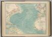
North Atlantic Ocean.
1 : 19000000 Johnston, W. & A.K.
Pilot chart of the North Atlantic Ocean
1 : 14300000 Atlantský oceán (oblast) Maury, Matthew Fontaine Hydrographic Office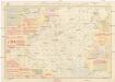
Pilot chart of the North Atlantic Ocean
1 : 14300000 Atlantský oceán (oblast) Maury, Matthew Fontaine Hydrographic Office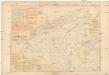
Pilot chart of the North Atlantic Ocean
1 : 14300000 Atlantský oceán (oblast) Maury, Matthew Fontaine Hydrographic Office