Maps of Venezuela

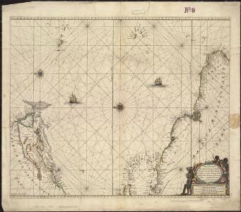
Pascaerte vande Vlaemsche, Soute, en Caribesche Eylanden, als mede Terra Nova, en de custen van Nova Francia, Nova Anglia, Nieu Nederlandt, Venezuela, Nueva Andalusia, Guiana en een gedeelte van Brazil
1 : 13000000
Terra nova, ac maris tractus circa Novam Franciam, Angliam, Belgium, Venezuelam Novam, Andalusiam, Guianan, et Brasiliam ; Terra neuf, en de custen van Nieu Vranckryck, Nieu Engeland, Nieu Nederland, Nieu Andalusia, Guiana en Venezuela
1 : 12521000
[145][148] Terra Nova ... Terra Neuf ..., uit: Atlas sive Descriptio terrarum orbis
Annotatie: Gedigitaliseerde versie. Amsterdam. Heiloo : Picturae (vervaardiger), 2015. tiff-bestand. Gedigitaliseerd: 07-01-2015; Origineel: Universiteitsbibliotheek Vrije Universiteit (XL.05127.-) ; Netherlands; Titelpagina ontbreekt Wit, Frederik de Amsterdam : Frederick de Wit
Pascaerte vande Vlaemsche, Soute, en Caribesche Eylanden, als mede Terra Nova, en de custen van Nova Francia, Nova Anglia, Nieu Nederlandt, Venezuela, Nueva Andalusia, Giuana, en een gedeelte van Brazil / Abraham Deur fecit
1 : 13500000 Annotatie: Uit: De zee-atlas, ofte water-weereld ... - Amsterdam : Pieter Goos, 1666 [Amsterdam : Pieter Goos]
Pascaerte van 't westelyckste deel vande Spaense Zee, tuschen Brasil, de zoute en Vlaemse eylanded, en voorwestwart
1 : 7000000
Terra Nova, ac maris tractus circa Novam Franciam, Angliam, Belgium, Venezuelam Novam Andalusiam, Guianam, et Brasiliam
1 Karte : Kupferdruck ; 47 x 56 cm Renard gedruckt by L. Renard
Pascaerte van Brazil en Nieu Nederlandt can Cuorvo en Flores tot de Barbados [Karte], in: De Nieuwe Groote Vermeerderde Zee-Atlas ofte Water-Werelt, S. 63.
1 Karte aus Atlas Doncker, Hendrick
Pascaerte van Brazil en Niev Nederlandt
1 Karte : Kupferdruck ; 43 x 54 cm Doncker by Hendrick Doncker inde Nieubrugh steegh int Stuurmans gereeschap
Pilot chart of the Central American waters
1 : 6000000 Mexický záliv Maury, Matthew Fontaine Hydrographic Office
Pilot chart of the Central American waters
1 : 6000000 Mexický záliv Maury, Matthew Fontaine Hydrographic Office
Pilot chart of the Central American waters
1 : 6000000 Mexický záliv Maury, Matthew Fontaine Hydrographic Office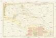
Pilot chart of the Central American waters
1 : 6000000 Mexický záliv Maury, Matthew Fontaine Hydrographic Office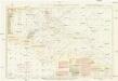
Pilot chart of the Central American waters
1 : 6000000 Mexický záliv Maury, Matthew Fontaine Hydrographic Office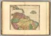
South America (northern half).
1 : 10200000 Tanner, Henry S.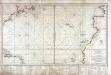
Carte réduite d'une partie de l'ocean Atlantique ou Occidental
1 Karte : Kupferdruck ; 46 x 81 cm Verdun de la Crenne; Borda; Pingré; Petit; Claret de Fleurieu s.n.
Terra Firma and the Caribbé Islands &c.
1 : 20000000
Depths and temperatures observed in the western part of the North Atlantic Ocean
1 : 7000000 United States Coast Survey U.S. Coast Survey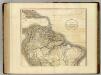
South America north.
1 : 10500000 Cary, John, ca. 1754-1835
Amerikanisch-Spanischer kriegsschauplatz
1 : 7500000
A map of Caracas.
from Carey's general atlas, improved and enlarged : being a collection of maps of the world and quarters, their principal empires, kingdoms, &c.
South America and West Indies.
1 : 10500000 Tanner, Henry S.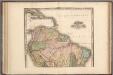
South America and West Indies.
1 : 10500000 Tanner, Henry S.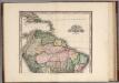
South America and West Indies. 1818
1 : 10500000 Tanner, Henry S.
A Correct Map of the United States.
1 : 4850000 Lewis, Samuel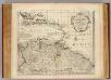
Terra Firma, Caribbean.
1 : 6800000 Bowen, Emanuel
Terra Firma and the Caribbe Island & c.
Herman Moll fue un librero, geógrafo, cartógrafo y grabador de origen holandés-alemán que se trasladó a Londres en 1678. Allí comenzó su propio negocio como vendedor de mapas, y a principios del siglo XVIII se había convertido en el editor de mapas más importantes de Londres, una ciudad que experimentaba el entusiasmo generado por el crecimiento ultramarino del imperio británico. Los cafés de Londres eran lugares propicios para la obtención de noticias sobre del Nuevo Mundo; allí se escuchaban relatos de viajes exóticos y se proyectaban potenciales negocios ultramarinos. Geógrafos y comerciantes de mapas como Herman Moll encontraban en estos cafés el ambiente y las conexiones necesarias para garantizar la prosperidad de su oficio y negocio cartográfico. Entre los amigos de Moll se cuentan el bucanero William Dampier (1651-1715) famoso por sus tres circunnavegaciones al mundo (1703-1707) y sus saqueos a Portobello, Panamá y Guayaquil. Por cierto, una de las aventuras de Dampier cuando capturó un Galeón de Manila y rescató a Alexander Selkirk de una isla desierta al sur de Chile; terminaron inspirando a Daniel Defoe para escribir su famoso Robinson Crusoe (1719). Daniel Defoe amigo de Moll, al igual que, Dampier, y que Jonathan Swift, reconocido autor de los Viajes de Gulliver (1726). Moll produjo, los mapas incluidos en las ediciones originales de ambas novelas. Este mapa de Tierra Firme hace parte de uno de los múltiples atlas que Moll produjo para la popularización de datos geográficos sobre el Nuevo Mundo. Moll, Herman (1654–1732)
A new map of part of the United States of North America : containing those of New York, Vermont, New Hampshire, Massachusets, Connecticut, Rhode Island, Pennsylvania, New Jersey, Delaware, Maryland and Virginia from the latest authorities / by John Cary,
from Charts and maps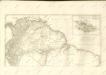

Theatre de la guerre presente en Amerique.
from Revolutionary War, 1775-1783