Maps of Metropolitan France
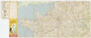
[Kaart], uit: Grandes routes : la France en 2 cartes
1 : 1000000 Annotatie: De zuidelijke helft ontbreekt Paris : Services de Tourisme Michelin
Gallia Vetus, Ad Iul Caesaris Commentaria [...] [Karte], in: Le théâtre du monde, ou, Nouvel atlas contenant les chartes et descriptions de tous les païs de la terre, Bd. 2, S. 182.
1 Karte aus Atlas Blaeu, Willem Janszoon und Blaeu, Joan Blaeu, Willem Janszoon
Le Royaume De France, distingué suivant l'estendue de Toutes Ses Provinces Et Ses Acquisitions, dans l'Espagne, dans l'Italie, dans l'Allemagne [...] [Karte], in: Atlas nouveau, contenant toutes les parties du monde [...], Bd. 1, S. 74.
1 Karte aus Atlas Sanson, Nicolas Jaillot, Alexis Hubert und Mortier, Pieter
Gallia Vetus, Ad Iul Caesaris Commentaria, ex Conatibus Geographicis Abrah Ortelii. [Karte], in: Novus Atlas, das ist, Weltbeschreibung, Bd. 2, S. 189.
1 Karte aus Atlas Blaeu, Joan Blaeu, Willem Janszoon
Gallia Vetus, Ad Iul Caesaris Commentaria [Karte], in: Theatrum orbis terrarum, sive, Atlas novus, Bd. 2, S. 187.
1 Karte aus Atlas Blaeu, Joan Blaeu, Willem Janszoon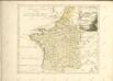
Gallia Le Royaume De France. [Karte], in: Le théâtre du monde, ou, Nouvel atlas contenant les chartes et descriptions de tous les païs de la terre, Bd. 2, S. 10.
1 Karte aus Atlas Blaeu, Willem Janszoon und Blaeu, Joan Blaeu, Willem Janszoon
Gallia Vetus, Ad Iulii Caesaris commentaria [...] [Karte], in: Theatrum orbis terrarum, S. 371.
1 Karte aus Atlas Ortelius, Abraham
Gallia Vetus, Ad Iulij Caesaris commentaria. [Karte], in: Theatrum orbis terrarum, S. 467.
1 Karte aus Atlas Ortelius, Abraham Vrients, Jan Baptista
France Geologique.
1 : 3700000 Migeon, J.
Gallia Antiqua.
1 : 5500000 Anville, Jean Baptiste Bourguignon d, 1697-1782
[XII], uit: Geognostische Karte des Oesterreichischen Kaiserstaates mit einem grossen Theile Deutschland's u. Italien / hauptsachlich nach ... Haidinger's geognostischer Karte dieses Staates bearb. von Josef Scheda
1 : 3000000 titelvariant: General-Karte von Europa in 25 Blättern; Annotatie: Bijlage bij: General-Karte von Europa in 25 Blättern. - 1:2.592.000. - 1845-1847 Scheda, Joseph Wien : K.K. Militär. Geografisch. Institut
A new and accurate map of France with its aquisitions / composed from the latest surveys assited by the most approved maps & charts & regulated by astrol. Observations by Eman. Bowen
Bowen, Emmanuel
France.
1 : 4400000 Vivien de St Martin, L.
Gallia Le Royaume De France. [Karte], in: Theatrum orbis terrarum, sive, Atlas novus, Bd. 2, S. 10.
1 Karte aus Atlas Blaeu, Joan Blaeu, Willem Janszoon
France.
1 : 3000000 Andriveau-Goujon, J.
Regnum Galliae divisum in duodecim gubernationes Piccardiae, Normandiae, Insulae Franciae, Britanniae, Aureliae, Burgundiae, Lugdini, Aquitaniae, Languedoci, Delphinatus et Provintiae
1 : 250000 [...] et hac tabula expressum a Gerardo et Leonardo Valk [Amsterdam] : [Gerardus et Leonardus Valk]
Regnum Galliæ
1 Karte : Kupferdruck ; 46 x 58 cm Valck; Valck G. und L. Valck
France.
1 : 3000000 Lapie, M. (Pierre), 1779-1850
Gallia [Karte], in: Gerardi Mercatoris Atlas, sive, Cosmographicae meditationes de fabrica mundi et fabricati figura, S. 213.
1 Karte aus Atlas Mercator, Gerhard Montanus, Petrus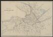
Gallia Vetus Ad Iulii Caesaris commentaria. [Karte], in: Gerardi Mercatoris et I. Hondii Newer Atlas, oder, Grosses Weltbuch, Bd. 2, S. 152.
1 Karte aus Atlas Mercator, Gerhard und Hondius, Jodocus Jansson, Jan
Le Royaume De France. [Karte], in: Novus Atlas, das ist, Weltbeschreibung, Bd. 2, S. 18.
1 Karte aus Atlas Blaeu, Joan Blaeu, Willem Janszoon
Tabula Moderna Francie [Karte], in: [Clavdii Ptholomei Cosmographi ...], S. 257.
1 Karte aus Atlas Nicolaus Germanus [und Ptolemaeus, Claudius]
Gallia Transalpina e le sue successive divisioni.
1 : 3030000 Picquet, C.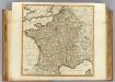
France, departments.
1 : 2300000 Robert Laurie & James Whittle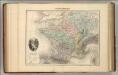
France Physique.
1 : 3700000 Migeon, J.
Gallia Vetus Ad Iulii Caesaris commentaria. [Karte], in: Novus atlas absolutissimus, Bd. 4, S. 23.
1 Karte aus Atlas Janssonius Offizin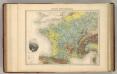
France Hypsometrique.
1 : 3700000 Migeon, J.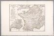
![[Kaart], uit: Grandes routes : la France en 2 cartes](https://images-2.georeferencer.com/images/iiif/615527897258/full/,300/0/native.jpg)

