Maps of Metropolitan France

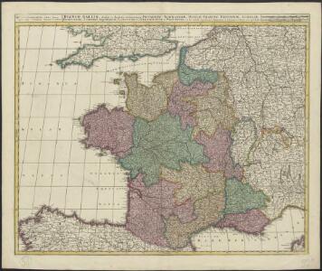
Regnum Galliae divisum in duodecim gubernationes Piccardiae, Normandiae, Insulae Franciae, Britanniae, Aureliae, Burgundiae, Lugdini, Aquitaniae, Languedoci, Delphinatus et Provintiae
1 : 250000 [...] et hac tabula expressum a Gerardo et Leonardo Valk [Amsterdam] : [Gerardus et Leonardus Valk]
Regnum Galliæ
1 Karte : Kupferdruck ; 46 x 58 cm Valck; Valck G. und L. Valck
Gallia Antiqua ex aevi Romani monumentis eruta, et serenissimi Carnutum ducis munificentia publici juris facta / auctor d'Anville ; [gravé par] De-la-Haye
1 : 2500000 Annotatie: Met lijst van Romeinse provincies: I-XVII; In: [Atlas du Sr. d'Anville], bl. 7; Annotatie geografische gegevens: Met schaalstokken Jean-Baptiste Bourguignon d' Anville 1697-1782; Guillaume Nicolas Delahaye 1727-1802 [Paris : apud auctorem]
France.
1 : 2800000 Buache, Philippe, 1700-1773
France.
1 : 3000000 Andriveau-Goujon, J.
Gallia Antiqua.
1 : 5500000 Anville, Jean Baptiste Bourguignon d, 1697-1782
France.
1 : 2300000 Thomson, John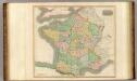
France, provinces.
1 : 2300000 Thomson, John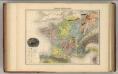
France Geologique.
1 : 3700000 Migeon, J.
Gaule sous les Romains.
1 : 3700000 Migeon, J.
Gallia Le Royaume De France. [Karte], in: Le théâtre du monde, ou, Nouvel atlas contenant les chartes et descriptions de tous les païs de la terre, Bd. 2, S. 10.
1 Karte aus Atlas Blaeu, Willem Janszoon und Blaeu, Joan Blaeu, Willem Janszoon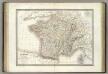
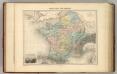
France.
1 : 3000000 Lapie, M. (Pierre), 1779-1850
A new and accurate map of France with its aquisitions / composed from the latest surveys assited by the most approved maps & charts & regulated by astrol. Observations by Eman. Bowen
Bowen, Emmanuel
Gallia Le Royaume De France. [Karte], in: Theatrum orbis terrarum, sive, Atlas novus, Bd. 2, S. 10.
1 Karte aus Atlas Blaeu, Joan Blaeu, Willem Janszoon
Le Royaume De France, distingué suivant l'estendue de Toutes Ses Provinces Et Ses Acquisitions, dans l'Espagne, dans l'Italie, dans l'Allemagne [...] [Karte], in: Atlas nouveau, contenant toutes les parties du monde [...], Bd. 1, S. 74.
1 Karte aus Atlas Sanson, Nicolas Jaillot, Alexis Hubert und Mortier, Pieter
Gallia Vetus, Ad Iul Caesaris Commentaria [Karte], in: Theatrum orbis terrarum, sive, Atlas novus, Bd. 2, S. 187.
1 Karte aus Atlas Blaeu, Joan Blaeu, Willem Janszoon
Galliae supra omnes in hac forma editiones locupletißima et exatißima descriptio. [Karte], in: Gerardi Mercatoris et I. Hondii Newer Atlas, oder, Grosses Weltbuch, Bd. 2, S. 16.
1 Karte aus Atlas Mercator, Gerhard und Hondius, Jodocus Jansson, Jan
Homannův atlas světa
1 : 2350000
Le royaume de France
1 : 2670000 Francie Seutter, Matthäus Matthieu Seutter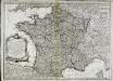
Nouvelle carte du royaume de France
1 Karte : Kupferdruck ; 45 x 62 cm Delafosse; Basset; Basset chez Basset rue St. Jacques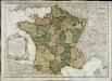
Nouvelle carte du royaume de France
1 Karte : Kupferdruck ; 45 x 62 cm Delafosse; Daumont chez Daumont rue St. Martin près St. Julien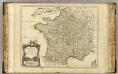
France.
1 : 2350000 Robert de Vaugondy, Gilles, 1688-1766
Gallia Vetus, Ad Iul Caesaris Commentaria, ex Conatibus Geographicis Abrah Ortelii. [Karte], in: Novus Atlas, das ist, Weltbeschreibung, Bd. 2, S. 189.
1 Karte aus Atlas Blaeu, Joan Blaeu, Willem Janszoon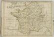

Le Royaume De France. [Karte], in: Novus Atlas, das ist, Weltbeschreibung, Bd. 2, S. 18.
1 Karte aus Atlas Blaeu, Joan Blaeu, Willem Janszoon
Gallia Vetus, Ad Iul Caesaris Commentaria [...] [Karte], in: Le théâtre du monde, ou, Nouvel atlas contenant les chartes et descriptions de tous les païs de la terre, Bd. 2, S. 182.
1 Karte aus Atlas Blaeu, Willem Janszoon und Blaeu, Joan Blaeu, Willem Janszoon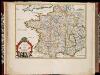
La France en toute son estendue sous le Roy Louis le Grand l'an 1682 / par P. du Val
1 : 2500000 Annotatie: Origineel is Blad 13 in atlas factice Duval, Pierre A Paris : chez l'auteur
Gallia [Karte], in: Gerardi Mercatoris Atlas, sive, Cosmographicae meditationes de fabrica mundi et fabricati figura, S. 213.
1 Karte aus Atlas Mercator, Gerhard Montanus, Petrus