Maps of Metropolitan France
La France en toute son estendue sous le Roy Louis le Grand l'an 1682 / par P. du Val
1 : 2500000 Annotatie: Origineel is Blad 13 in atlas factice Duval, Pierre A Paris : chez l'auteur
Le royaume de France
1 : 2670000 Francie Seutter, Matthäus Matthieu Seutter
France.
1 : 3000000 Andree, Richard; Times (London, England)
France Politique.
1 : 3700000 Migeon, J.
Galliae supra omnes in hac forma editiones locupletißima et exatißima descriptio. [Karte], in: Gerardi Mercatoris et I. Hondii Newer Atlas, oder, Grosses Weltbuch, Bd. 2, S. 16.
1 Karte aus Atlas Mercator, Gerhard und Hondius, Jodocus Jansson, Jan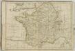

France.
1 : 2800000 Buache, Philippe, 1700-1773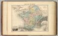
Gaule sous les Romains.
1 : 3700000 Migeon, J.
Gallia Le Royaume De France. [Karte], in: Theatrum orbis terrarum, sive, Atlas novus, Bd. 2, S. 10.
1 Karte aus Atlas Blaeu, Joan Blaeu, Willem Janszoon
Gallia [Karte], in: Gerardi Mercatoris Atlas, sive, Cosmographicae meditationes de fabrica mundi et fabricati figura, S. 213.
1 Karte aus Atlas Mercator, Gerhard Montanus, Petrus
Gallia concinnata ad magnum numerum mapparum particularium manu scriptarum vel impreßarum juxta genuinum situm locorum et collatarum cum itinerariis veteribus et recentioribus
1 : 3600000 Francie Delisle, Guillaume Seutter, Matthäus Matth. Seutter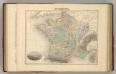
France en 1789.
1 : 3300000 Migeon, J.
France en Relief.
Vivien St Martin, L.

Gallia Vetus, Ad Iul Caesaris Commentaria, ex Conatibus Geographicis Abrah Ortelii. [Karte], in: Novus Atlas, das ist, Weltbeschreibung, Bd. 2, S. 189.
1 Karte aus Atlas Blaeu, Joan Blaeu, Willem Janszoon
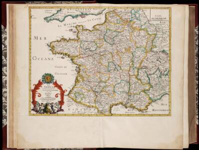
GALLIA | LE | ROYAVME | DE | FRANCE.
I. vanden Ende fec. Amsterodami | Excudebat Guilielmus | Blaeuw Sub Signo Solarii
Charte féodale de la France
1 : 2370000 Francie Perrot, A. M. Barante.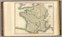
France.
1 : 2300000 Thomson, John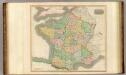
France, provinces.
1 : 2300000 Thomson, John
Gallia Vetus, Ad Iul Caesaris Commentaria [Karte], in: Theatrum orbis terrarum, sive, Atlas novus, Bd. 2, S. 187.
1 Karte aus Atlas Blaeu, Joan Blaeu, Willem Janszoon
Königreich Frankreich

Nouvelle carte itinéraire de la France par départements et divisions militaires ...
From France
Le Royaume De France. [Karte], in: Novus Atlas, das ist, Weltbeschreibung, Bd. 2, S. 18.
1 Karte aus Atlas Blaeu, Joan Blaeu, Willem Janszoon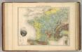
France Hypsometrique.
1 : 3700000 Migeon, J.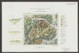
Gallia Le Royaume De France. [Karte], in: Le théâtre du monde, ou, Nouvel atlas contenant les chartes et descriptions de tous les païs de la terre, Bd. 2, S. 10.
1 Karte aus Atlas Blaeu, Willem Janszoon und Blaeu, Joan Blaeu, Willem Janszoon
Frankreich
Hypsometrischer Atlas Ziegler, Jakob Melchior Topogr. Anstalt v. J. Wurster u. Comp.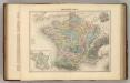
France Feodale.
1 : 3300000 Migeon, J.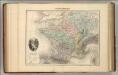
France Physique.
1 : 3700000 Migeon, J.