Maps of Moussey

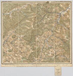
Blatt XI: Oberes Breuschthal, uit: Karte der Vogesen / herausgegeben vom Central-Ausschuss des Vogesen-Clubs ; bearbeitet im kartographischen Institut von Carl Flemming in Glogau
1 : 500000 Annotatie: Bladwijzer op omslag; Annotatie geografische gegevens: Legenda Vogesen-Club. Central-Ausschuss Strassburg : in Kommission bei J.H. Ed. Heitz (Heitz & Mündel)
Meßtischblatt 3625 : Blen, 1916
1 : 250000 Blen. - Aufn. 1883, hrsg. 1885, B. 09, N. 13, Aufldr. 1916. - 1:25000. - [Berlin]: Reichsamt für Landesaufnahme, 1916. - 1 Kt.
Le Flambeau de la Guerre Allumee au Rhin
Mollova mapová sbírka Delisle, Guillaume Schenk, Peter II
Meßtischblatt [7509] : Schirmeck, 1885
1 : 250000 Schirmeck. - 1:25000. - [Berlin]: Reichsamt für Landesaufnahme, 1885. - 1 Kt.
Meßtischblatt 3634 : Weiler, 1913
1 : 250000 Weiler. - Aufn. 1883, hrsg. 1885, gedr. [19]13. - 1:25000. - [Berlin]: Reichsamt für Landesaufnahme, 1913. - 1 Kt.
Meßtischblatt 3634 : Weiler, 1885
1 : 250000 Weiler. - Aufn. 1883. - 1:25000. - [Berlin]: Reichsamt für Landesaufnahme, 1885. - 1 Kt.
Le Theatre de la Guerre Sur le Haut Rhein
1 : 142000 Mollova mapová sbírka Sanson, Guillaume
Le Cours du Rhein, depuis Spire jusqu'a Mayence
1 : 180000 Mollova mapová sbírka Fer, Nicolas de Fer, Nicolas de
Le cours du Rhin de Bâle à Hert près Philisbourg contenant l'Alsace et partie du Brisgau, 3
1 Blatt : 77 x 52 cm Le Rouge
176. Markirch, uit: Topographische Uebersichtskarte des Deutschen Reiches / herausgegeben v. d. Kartogr. Abt. d. Königl. Preuß. Landesaufnahme
1 : 200000 titelvariant: Topogr. Übersichtskarte des Deutschen Reiches; Annotatie: Titel boven bladen ook: Topogr. Übersichtskarte des Deutschen Reiches; Annotatie geografische gegevens: Op elk blad twee maatstokken: 10 Kilometer = 5,5 cm; 1 geogr. Meile = 3,6 cm; Legenda onder op elk blad Königlich Preußische Landesaufnahme. Kartographische Abtheilung [S.l : Königlich Preußische Landesaufnahme, Kartographische Abtheilung]
163 Colmar.
1 : 86400 Cassini family; Cassini, Cesar-Francois, 1714-1784
[Colmar]
1 Blatt : 60 x 91 cm s.n.
Meßtischblatt 3620 : Lascemborn, 1883
1 : 250000 Lascemborn. - Aufn. 1882. - 1:25000. - [Berlin]: Reichsamt für Landesaufnahme, 1883. - 1 Kt.
Meßtischblatt 3621 : Lützelhausen, 1909
1 : 250000 Lützelhausen. - Aufn. 1882. - 1:25000. - [Berlin]: Reichsamt für Landesaufnahme, 1909. - 1 Kt.
Meßtischblatt 3621 : Lützelhausen, 1883
1 : 250000 Lützelhausen. - Aufn. 1882. - 1:25000. - [Berlin]: Reichsamt für Landesaufnahme, 1883. - 1 Kt.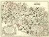
Archidiacnés de Port, et Prevosté de St. Diey, dans l'Evesché de Tovl
1 : 240000 Mollova mapová sbírka Sanson, Nicolas Mariette, Pierre Sanson, Nicolas II
Tribocci
1 Karte : Kupferdruck ; 39 x 49 cm Sanson; Robert de Vaugondy; Somer chés le Sr. Robert geog. du roi quai de l'horloge
Alsatia superior cu[m] Suntgoa et Brisgoia
1 Karte : Kupferdruck ; 17 x 24 cm Mercator Cloppenburgh
Levci
1 Karte : Kupferdruck ; 41 x 56 cm Sanson; Robert de Vaugondy chés le Sr. Robert g. du roi quai de l'horloge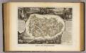
Dept. De La Meurthe.
1 : 395000 Levasseur, Victor.
Alsatia inferior
1 Karte : Kupferdruck ; 35 x 42 cm Hondius; Mercator Jodocus Hondius
Alsatia inferior
1 Karte : Kupferdruck ; 34 x 42 cm Mercator; Hondius excusum apud Henricum Hondium sub insigno atlantis
Alsatia inferior
1 Karte : Kupferdruck ; 17 x 24 cm Mercator; Keere Cloppenburgh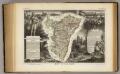
Dept. Du Bas Rhin.
1 : 455000 Levasseur, Victor.

Alsatia inferior
1 Karte : Kupferdruck ; 34 x 41 cm Mercator s.n.
[Atlas départemental : La France et ses colonies] No. 53 Meurthe
1 : 670000 publ. par Michel fils ainé [dressé par A. Lorrain, et gravé par H. Dandeleux] Versailles [etc.] : Barreswil et Andrieux
Département de la Meurte
1 Karte : Kupferdruck ; 48 x 48 cm Houdan au bureau de l'atlas national rue de la Harpe no. 26, et au dépôt du dit atlas rue de la Monnoye no. 5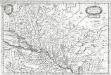
Alsatia inferior
1 Karte : Kupferdruck ; 19 x 29 cm Merian Merian
[Lothringen, südlicher Teil]
1 Karte : Kupferdruck ; 35 x 46 cm Mercator; Hondius Henricus Hondius
[Lothringen, südlicher Teil]
1 Karte : Kupferdruck ; 35 x 46 cm Mercator; Hondius Jodocus Hondius