Maps of Sélestat-Erstein

Le Theatre de la Guerre Sur le Haut Rhein
1 : 142000 Mollova mapová sbírka Sanson, Guillaume
Le Cours du Rhein, depuis Spire jusqu'a Mayence
1 : 180000 Mollova mapová sbírka Fer, Nicolas de Fer, Nicolas de
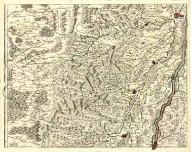
Le cours du Rhin de Bâle à Hert près Philisbourg contenant l'Alsace et partie du Brisgau, 3
1 Blatt : 77 x 52 cm Le Rouge
163 Colmar.
1 : 86400 Cassini family; Cassini, Cesar-Francois, 1714-1784
[Colmar]
1 Blatt : 60 x 91 cm s.n.
Le Flambeau de la Guerre Allumee au Rhin
Mollova mapová sbírka Delisle, Guillaume Schenk, Peter II
Le Flambeau de la Guerre Allumee au Rhin
Mollova mapová sbírka Delisle, Guillaume Schenk, Peter II
Blatt XI: Oberes Breuschthal, uit: Karte der Vogesen / herausgegeben vom Central-Ausschuss des Vogesen-Clubs ; bearbeitet im kartographischen Institut von Carl Flemming in Glogau
1 : 500000 Annotatie: Bladwijzer op omslag; Annotatie geografische gegevens: Legenda Vogesen-Club. Central-Ausschuss Strassburg : in Kommission bei J.H. Ed. Heitz (Heitz & Mündel)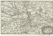
Strasburg
1 : 160000 Mollova mapová sbírka Person, Nikolaus Person, Nicolas
Carte Tres Particuliere Des Environs de la Ville de Strasbourg Avec toutes les subdivisions des Terres y comprises
1 : 130000 Mollova mapová sbírka Sengre, Henri Sengre, Henry
Accuratissima Territorij Argentoratensis et Annexorum Tabella In lucem edita
1 : 90000 Mollova mapová sbírka Person, Nikolaus Person, Nicolas
Blatt X: Molsheim, uit: Karte der Vogesen / herausgegeben vom Central-Ausschuss des Vogesen-Clubs ; bearbeitet im kartographischen Institut von Carl Flemming in Glogau
1 : 500000 Annotatie: Bladwijzer op omslag; Annotatie geografische gegevens: Legenda Vogesen-Club. Central-Ausschuss Strassburg : in Kommission bei J.H. Ed. Heitz (Heitz & Mündel)
Topographische - Carte des Rheinstromes und seiner beiderseitigen Ufer von Hüningen bis Lauterburg...

Blatt 7. Burkheim, uit: Topographische Karte des Rheinstromes und seiner beiderseitigen Ufer von Hueningen bis Lauterburg oder längs der Französich-Badischen Gränze, ... / ... reducirt und gezeichnet ... im Bureau der Grossherzoglich Badischen Rheingränz-Berichtigungs Commission
1 : 20000 titelvariant: Rheingränz-Carte; Annotatie: Voor aanwezige bladen zie overzichtsblad Grossherzogliche Badische Rheingränz-Berichtigungs Commission. Bureau Freiburg im Breisgau : im Herder'schen Künst-Institut
Meßtischblatt [7811] : Sasbach, 1920
1 : 250000 Sasbach. - Zwischenaufl., aufgen. 1912. - 1:25000. - Leipzig: Giesecke & Devrient, 1920. - 1 Kt.
Meßtischblatt [7811] : Sasbach, 1878
1 : 250000 Sasbach. - 1:25000. - Leipzig: Giesecke & Devrient, 1878. - 1 Kt.
Meßtischblatt 3652 : Rappoltsweiler, 1913
1 : 250000 Rappoltsweiler. - Aufn. 1884, . - 1:25000. - [Berlin]: Reichsamt für Landesaufnahme, [1913]. - 1 Kt.
Meßtischblatt 3651 : Urbeis, 1913
1 : 250000 Urbeis. - [Aufn. 18849. - 1:25000. - [Berlin]: Reichsamt für Landesaufnahme, [1913]. - 1 Kt.
Meßtischblatt 3651 : Urbeis, 1886
1 : 250000 Urbeis. - Aufn. 1884. - 1:25000. - [Berlin]: Reichsamt für Landesaufnahme, 1886. - 1 Kt.
Meßtischblatt 3652 : Rappoltsweiler, 1886
1 : 250000 Rappoltsweiler. - Aufn. 1884. - 1:25000. - [Berlin]: Reichsamt für Landesaufnahme, 1886. - 1 Kt.
Meßtischblatt [7711] : Weisweil (Rheinbrücke), 1886
1 : 250000 Weisweil (Rheinbrücke). - 1:25000. - Leipzig: Giesecke & Devrient, 1886. - 1 Kt.
Meßtischblatt 3645 : Schlettstadt, 1886
1 : 250000 Schlettstadt. - Aufn. 1884. - 1:25000. - [Berlin]: Reichsamt für Landesaufnahme, 1886. - 1 Kt.
Meßtischblatt 3644 : Markirch, 1886
1 : 250000 Markirch. - Aufn. 1884. - 1:25000. - [Berlin]: Reichsamt für Landesaufnahme, 1886. - 1 Kt.
Meßtischblatt 3643 : Eckerich, 1914
1 : 250000 Eckerich. - Aufn. 1884, hrsg. 1885, Aufl.-dr. 1914. - 1:25000. - [Berlin]: Reichsamt für Landesaufnahme, 1914. - 1 Kt.
Meßtischblatt 3636 : Benfeld, 1885
1 : 250000 Benfeld. - Aufn. 1883. - 1:25000. - [Berlin]: Reichsamt für Landesaufnahme, 1885. - 1 Kt.
Meßtischblatt 3635 : Dambach, 1917
1 : 250000 Dambach. - Aufn. 1883, hrsg. 1885, B. 08, Aufldr. 1917. - 1:25000. - [Berlin]: Reichsamt für Landesaufnahme, 1917. - 1 Kt.
Meßtischblatt 3635 : Dambach, 1885
1 : 250000 Dambach. - Aufn. 1883. - 1:25000. - [Berlin]: Reichsamt für Landesaufnahme, 1885. - 1 Kt.
Meßtischblatt 3634 : Weiler, 1913
1 : 250000 Weiler. - Aufn. 1883, hrsg. 1885, gedr. [19]13. - 1:25000. - [Berlin]: Reichsamt für Landesaufnahme, 1913. - 1 Kt.
Meßtischblatt 3634 : Weiler, 1885
1 : 250000 Weiler. - Aufn. 1883. - 1:25000. - [Berlin]: Reichsamt für Landesaufnahme, 1885. - 1 Kt.