Maps of Moussey

Le Flambeau de la Guerre Allumee au Rhin
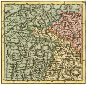
Mollova mapová sbírka Delisle, Guillaume Schenk, Peter II
Blatt XI: Oberes Breuschthal, uit: Karte der Vogesen / herausgegeben vom Central-Ausschuss des Vogesen-Clubs ; bearbeitet im kartographischen Institut von Carl Flemming in Glogau
1 : 500000 Annotatie: Bladwijzer op omslag; Annotatie geografische gegevens: Legenda Vogesen-Club. Central-Ausschuss Strassburg : in Kommission bei J.H. Ed. Heitz (Heitz & Mündel)
Meßtischblatt 3644 : Markirch, 1886
1 : 250000 Markirch. - Aufn. 1884. - 1:25000. - [Berlin]: Reichsamt für Landesaufnahme, 1886. - 1 Kt.
Meßtischblatt 3643 : Eckerich, 1914
1 : 250000 Eckerich. - Aufn. 1884, hrsg. 1885, Aufl.-dr. 1914. - 1:25000. - [Berlin]: Reichsamt für Landesaufnahme, 1914. - 1 Kt.
Meßtischblatt 3634 : Weiler, 1913
1 : 250000 Weiler. - Aufn. 1883, hrsg. 1885, gedr. [19]13. - 1:25000. - [Berlin]: Reichsamt für Landesaufnahme, 1913. - 1 Kt.
Meßtischblatt 3634 : Weiler, 1885
1 : 250000 Weiler. - Aufn. 1883. - 1:25000. - [Berlin]: Reichsamt für Landesaufnahme, 1885. - 1 Kt.
Meßtischblatt 3625 : Blen, 1916
1 : 250000 Blen. - Aufn. 1883, hrsg. 1885, B. 09, N. 13, Aufldr. 1916. - 1:25000. - [Berlin]: Reichsamt für Landesaufnahme, 1916. - 1 Kt.
Meßtischblatt [7509] : Schirmeck, 1885
1 : 250000 Schirmeck. - 1:25000. - [Berlin]: Reichsamt für Landesaufnahme, 1885. - 1 Kt.
Le cours du Rhin de Bâle à Hert près Philisbourg contenant l'Alsace et partie du Brisgau, 3
1 Blatt : 77 x 52 cm Le Rouge
163 Colmar.
1 : 86400 Cassini family; Cassini, Cesar-Francois, 1714-1784
[Colmar]
1 Blatt : 60 x 91 cm s.n.
Meßtischblatt 3645 : Schlettstadt, 1886
1 : 250000 Schlettstadt. - Aufn. 1884. - 1:25000. - [Berlin]: Reichsamt für Landesaufnahme, 1886. - 1 Kt.
Meßtischblatt 3635 : Dambach, 1917
1 : 250000 Dambach. - Aufn. 1883, hrsg. 1885, B. 08, Aufldr. 1917. - 1:25000. - [Berlin]: Reichsamt für Landesaufnahme, 1917. - 1 Kt.
Meßtischblatt 3635 : Dambach, 1885
1 : 250000 Dambach. - Aufn. 1883. - 1:25000. - [Berlin]: Reichsamt für Landesaufnahme, 1885. - 1 Kt.
Meßtischblatt 3627 : Barr, 1884
1 : 250000 Barr. - Aufn. 1883. - 1:25000. - [Berlin]: Reichsamt für Landesaufnahme, 1884. - 1 Kt.
Le Theatre de la Guerre Sur le Haut Rhein
1 : 142000 Mollova mapová sbírka Sanson, Guillaume
Le Cours du Rhein, depuis Spire jusqu'a Mayence
1 : 180000 Mollova mapová sbírka Fer, Nicolas de Fer, Nicolas de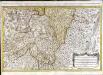
Les prevotez, offices, senéchaussée et comté, qui font partie des balliages de Vosge ou Mirecour et de Nancy
1 Karte : Kupferdruck ; 43 x 68 cm Jaillot Alexis-Hubert Jaillot
Alsatia superior cu[m] Suntgoa et Brisgoia
1 Karte : Kupferdruck ; 17 x 24 cm Mercator Cloppenburgh
Alsatia superior cu[m] Suntgoia [et] Brisgoia
1 Karte : Kupferdruck ; 34 x 46 cm Mercator s.n.
Alsatia inferior
1 Karte : Kupferdruck ; 35 x 42 cm Hondius; Mercator Jodocus Hondius
Alsatia inferior
1 Karte : Kupferdruck ; 34 x 42 cm Mercator; Hondius excusum apud Henricum Hondium sub insigno atlantis
Alsatia inferior
1 Karte : Kupferdruck ; 17 x 24 cm Mercator; Keere Cloppenburgh
Dept. Du Bas Rhin.
1 : 455000 Levasseur, Victor.
Alsatia inferior
1 Karte : Kupferdruck ; 34 x 41 cm Mercator s.n.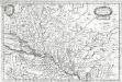
Alsatia inferior
1 Karte : Kupferdruck ; 19 x 29 cm Merian Merian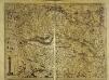
Alsatia superior cu[m] Suntgoia [et] Brisgoia
1 Karte : Kupferdruck ; 34 x 47 cm Hondius; Mercator Jodocus Hondius
Alsatia superior cu[m] Suntgoia [et] Brisgoia
1 Karte : Kupferdruck ; 35 x 46 cm Mercator; Hondius sumptibus Henrici Hondij
Alsatia Superior cum Svntgoia et Brisgoia
1 : 270000 Mollova mapová sbírka Schenk, Pieter Schenk, Peter I