Maps of Huttenheim

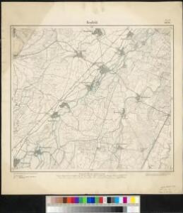
Meßtischblatt 3636 : Benfeld, 1885
1 : 250000 Benfeld. - Aufn. 1883. - 1:25000. - [Berlin]: Reichsamt für Landesaufnahme, 1885. - 1 Kt.
Le Flambeau de la Guerre Allumee au Rhin
Mollova mapová sbírka Delisle, Guillaume Schenk, Peter II
Charte über das Grosherzogthum Baaden
1 : 180000 Bádensko (Německo)
Topographische - Carte des Rheinstromes und seiner beiderseitigen Ufer von Hüningen bis Lauterburg...

Blatt 9. Kappel, uit: Topographische Karte des Rheinstromes und seiner beiderseitigen Ufer von Hueningen bis Lauterburg oder längs der Französich-Badischen Gränze, ... / ... reducirt und gezeichnet ... im Bureau der Grossherzoglich Badischen Rheingränz-Berichtigungs Commission
1 : 20000 titelvariant: Rheingränz-Carte; Annotatie: Voor aanwezige bladen zie overzichtsblad Grossherzogliche Badische Rheingränz-Berichtigungs Commission. Bureau Freiburg im Breisgau : im Herder'schen Künst-Institut
Carte über den Lauf des Rheins von Basel bis Lauterburg längs der Badisch - Französischen Grenze
[Colmar]
1 Blatt : 60 x 91 cm s.n.
Le cours du Rhin de Bâle à Hert près Philisbourg contenant l'Alsace et partie du Brisgau, 3
1 Blatt : 77 x 52 cm Le Rouge
163 Colmar.
1 : 86400 Cassini family; Cassini, Cesar-Francois, 1714-1784
177. Offenburg, uit: Topographische Uebersichtskarte des Deutschen Reiches / herausgegeben v. d. Kartogr. Abt. d. Königl. Preuß. Landesaufnahme
1 : 200000 titelvariant: Topogr. Übersichtskarte des Deutschen Reiches; Annotatie: Titel boven bladen ook: Topogr. Übersichtskarte des Deutschen Reiches; Annotatie geografische gegevens: Op elk blad twee maatstokken: 10 Kilometer = 5,5 cm; 1 geogr. Meile = 3,6 cm; Legenda onder op elk blad Königlich Preußische Landesaufnahme. Kartographische Abtheilung [S.l : Königlich Preußische Landesaufnahme, Kartographische Abtheilung]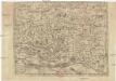
Abcon Terfeitv[n]g der Bistv[m]bs Strassbvrg samt andern angrenzende landschaften
1 : 400000 Štrasburk (Francie)
Argentoratensis Agri Descriptio. [Karte], in: Theatrum orbis terrarum, S. 175.
1 Karte aus Atlas Ortelius, Abraham
Argentoratensis Agri Descriptio. [Karte], in: Theatrum orbis terrarum, S. 267.
1 Karte aus Atlas Ortelius, Abraham Vrients, Jan Baptista
Territorium Argentoratense
1 Karte : Kupferdruck ; 36 x 48 cm Janssonius van Waesbergen; Pitt; Swart apud Janssonio-Waesbergios Mosem Pitt et Stephanum Swart
Territorium Argentoratense
1 Karte : Kupferdruck ; 36 x 48 cm Janssonius; Keere Ioannes Ianssonius excudit
Le Theatre de la Guerre Sur le Haut Rhein
1 : 142000 Mollova mapová sbírka Sanson, Guillaume
Territorium Argentoriatense. [Karte], in: Novus atlas absolutissimus, Bd. 2, S. 208.
1 Karte aus Atlas Janssonius Offizin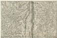
Le Cours du Rhein, depuis Spire jusqu'a Mayence
1 : 180000 Mollova mapová sbírka Fer, Nicolas de Fer, Nicolas de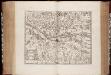
Territorium Argentoratense / apud Janssonio-Waesbergios, Mosem Pitt et Stephanum Swart
1 : 103000 Annotatie: Origineel is Blad 114 in atlas factice; Kaart toont het gebied rondom Straatsburg, deels gelegen in de Elzas en deels in Baden-Württemberg; In rechter bovenhoek: XLIV; Met wapens; Annotatie geografische gegevens: Schaalstok op de kaart: Milliaria Germanica communia; Oost boven Johannes Janssonius van Waesberge -1681?; Moses Pitt ca. 1654-1696; Stephanus Swart [Oxford : printed at the Theatre at Oxford]
Suevia Universa :
1 : 170000 Mollova mapová sbírka Michal, Jacques de Seutter, Matthäus Seutter, Matthäus
Alasatia superior et inferior III. tabulis delineata, 2
1 Blatt : 62 x 59 cm s.n.
Carte du chemin de fer de Strasbourg à Bâle
1 : 80000 Lithographie de Ve Levrault
Carte du chemin de fer de Strasbourg à Bâle
1 : 80000 Lithographie de Ve Levrault
Colmar 140, uit: [W. Liebenow's Special-Karte von Mittel-Europa]
1 : 300000 titelvariant: W. Liebenow's Mittel-Europa; Annotatie: Titel boven de bladen: W. Liebenow's Mittel-Europa Johannes Wilhelm Liebenow 1822-1897 Hannover : Hermann Oppermann
Colmar 140, uit: Special-Karte von Mittel-Europa / nach amtlichen Quellen bearbeitet von W. Liebenow
1 : 300000 titelvariant: W. Liebenow's Mittel-Europa; Annotatie: Titel boven de bladen: W. Liebenow's Mittel-Europa Johannes Wilhelm Liebenow 1822-1897 Frankfurt a. M. : Ludwig Ravenstein
Tribocci
1 Karte : Kupferdruck ; 39 x 49 cm Sanson; Robert de Vaugondy; Somer chés le Sr. Robert geog. du roi quai de l'horloge
Alsatia superior cu[m] Suntgoa et Brisgoia
1 Karte : Kupferdruck ; 17 x 24 cm Mercator Cloppenburgh
Accurata delineatio Brisgoviæ
1 Karte : Kupferdruck ; 56 x 48 cm Seutter; Drentwett Matthäus Seutter
Alsatia superior cu[m] Suntgoia [et] Brisgoia
1 Karte : Kupferdruck ; 34 x 46 cm Mercator s.n.