Maps of Solothurn

192. Oltingen, uit: Topographische Uebersichtskarte des Deutschen Reiches / herausgegeben v. d. Kartogr. Abt. d. Königl. Preuß. Landesaufnahme
1 : 200000 titelvariant: Topogr. Übersichtskarte des Deutschen Reiches; Annotatie: Titel boven bladen ook: Topogr. Übersichtskarte des Deutschen Reiches; Annotatie geografische gegevens: Op elk blad twee maatstokken: 10 Kilometer = 5,5 cm; 1 geogr. Meile = 3,6 cm; Legenda onder op elk blad Königlich Preußische Landesaufnahme. Kartographische Abtheilung [S.l : Königlich Preußische Landesaufnahme, Kartographische Abtheilung]
Wandkarte der Schweiz
1 : 200000 1 Karte auf 8 Blättern J.M. Ziegler Wurster, Winterthur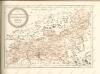

<<Die>> Cantone Solothurn und Basel
1 : 275000 1 Karte gest. v. J.J. Scheurmann Orell Füssli, Zürich
Atlas novus Reipublicae Helveticae
1 Atlas ([40] Bl., 97 S.) bey Orell, Gessner und Compagnie, Zürich
<<Die>> Cantone Solothurn und Basel
1 : 275000 1 Karte gest. v. J.J. Scheurmann Orell, Füssli & Cp., Zürich
<<Die>> Cantone Solothurn und Basel
1 : 275000 1 Karte gest. v. J.J. Scheurmann Orell, Füssli & Cp., Zürich
<<Die>> Cantone Solothurn und Basel
1 : 275000 1 Karte gest. v. J.J. Scheurmann Orell Füssli & Cp., Zürich
Atlas Suisse
1 : 120000 16 Karten levé et dessiné par J.H. Weiss [et Joachim Eugen Müller] aux frais de J.R. Meyer à Aarau dans les années 1786 à 1802 ; gravée [sic] par [Christophe] Guérin, [Matthias Gottfried] Eichler et [Johann Jakob] Scheurmann [Johann Rudolf Meyer], Aarau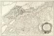
Ambrones in Helvetiis
1 : 240000 Mollova mapová sbírka Sanson, Nicolas Somer, Jean Pruthenus Mariette, Pierre
Atlas der alten Eidgenossenschaft in 20 Karten: Kanton Solothurn
Originaltitel: Canton Solothurn sive Pagus Helvetiae Solodurensis cum Confinibus. Mit Erklärung der Zeichen. Zeichnung: Walser, Gabriel (1695-1776), reformierter Pfarrer, von Teufen AR Herausgeber: Homännische Erben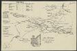
Vues des Alpes prise au dessus de l'heremitage à Soleure
[S.l.] : [s.n.]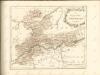

Karte des Kantons Aargau
1 : 250000 1 Karte J. Wurster & Comp., Winterthur
<<Der>> Canton Aargau
1 : 230000 1 Karte gez. u. gest. v. J.J. Scheurmann [Orell Füssli & Cp.], [Zürich]
<<Der>> Canton Bern
1 : 390000 1 Karte gez. u. gest. v. J. Scheuermann Orell, Füssli & Comp., Züric [i.e. Zürich]
Aargau
1 : 1450000 [Stumme Kartenskizzen der ganzen Schweiz und der einzelnen Kantone zu Unterrichtszwecken] Schulbuchhandlung Antenen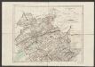
Canton Bern
1 : 390000 Scheuermann, Johann Jakob Orell, Füssli & Comp.
Bern, Burgdorf, Willisau
1 Vogelschaukarte Orell Füssli, Zürich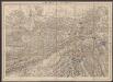
Solothurn - Basel - Brugg
1 : 100000 Kriegsdepot des Eidg. Topographischen Bureau's
Cantone Solothurn und Basel
1 : 275000 Scheuermann, Johann Jakob Orell, Füssli & Cp.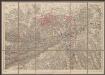
Solothurn - Basel - Brugg
1 : 100000 Kriegsdepot des Eidg. Topographischen Bureau's
Atlas de la Suisse
1 : 450000 1 Atlas (19 Bl.) dessiné par MM. H. Keller, Scheurmann, Pfyffer d'Altishofen, Osterwald, etc. ; gravé par M. Scheurmann Orell Füssli & Co., Zürich
Die Cantone Solothurn und Basel
1 : 227700 Basilej-venkov (Švýcarsko : kanton) Scheurmenn, J. J.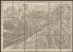
Solothurn - Basel - Brugg
1 : 100000 Kriegsdepot des Eidg. Topographischen Bureau's
Partie du canton de Berne de Soleure et de Fribourg
1 : 108000 Weiss, Johann Heinrich ; Guérin, Christophe ; Meyer, Johann Rudolf J. R. Meyer
Schüler-Handkarte des Kantons Solothurn
1 : 200000 1 Karte von J.S. Gerster Hofer & Burger graph. Anst., Zürich
Kanton Aargau: Trigonometrisches Netz
1 : 125000 Ohne Datumsangabe.
Taschen-Atlas der Schweiz
1 Atlas (25 S., 20 Taf.) gezeichnet und gestochen von Emil Wagner = Atlas de poche de la Suisse : 26 cartes en couleurs / dessinées et gravées par Émile Wagner Eggimann, Genf


