Maps of Solothurn

Schüler-Handkarte des Kantons Solothurn
1 : 200000 1 Karte von J.S. Gerster Hofer & Burger graph. Anst., Zürich
Atlas novus Reipublicae Helveticae
1 Atlas ([40] Bl., 97 S.) bey Orell, Gessner und Compagnie, Zürich
Cantone Solothurn und Basel
1 : 275000 Scheuermann, Johann Jakob Orell, Füssli & Cp.
Taschen-Atlas der Schweiz
1 Atlas (25 S., 20 Taf.) gezeichnet und gestochen von Emil Wagner = Atlas de poche de la Suisse : 26 cartes en couleurs / dessinées et gravées par Émile Wagner Eggimann, Genf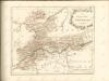

Atlas der alten Eidgenossenschaft in 20 Karten: Kanton Solothurn
Originaltitel: Canton Solothurn sive Pagus Helvetiae Solodurensis cum Confinibus. Mit Erklärung der Zeichen. Zeichnung: Walser, Gabriel (1695-1776), reformierter Pfarrer, von Teufen AR Herausgeber: Homännische Erben
<<Die>> Cantone Solothurn und Basel
1 : 275000 1 Karte gest. v. J.J. Scheurmann Orell, Füssli & Cp., Zürich
<<Der>> Canton Bern
1 : 390000 1 Karte gez. u. gest. v. J. Scheuermann Orell, Füssli & Comp., Züric [i.e. Zürich]
Atlas de la Suisse
1 : 450000 1 Atlas (19 Bl.) dessiné par MM. H. Keller, Scheurmann, Pfyffer d'Altishofen, Osterwald, etc. ; gravé par M. Scheurmann Orell Füssli & Co., Zürich
Canton Bern
1 : 390000 Scheuermann, Johann Jakob Orell, Füssli & Comp.
<<Die>> Cantone Solothurn und Basel
1 : 275000 1 Karte gest. v. J.J. Scheurmann Orell, Füssli & Cp., Zürich
Die Cantone Solothurn und Basel
1 : 227700 Basilej-venkov (Švýcarsko : kanton) Scheurmenn, J. J.
Archäologische Karte des Kantons Solothurn
1 : 100000 Heierli, Jakob Petri
Canton Solothurn sive pagus Helvetiae Solodurensis cum confinibus
1 Karte : Kupferdruck ; 23 x 25 cm Walser Homännische Erben
Solothurn - Basel - Brugg
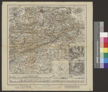
1 : 100000 Kriegsdepot des Eidg. Topographischen Bureau's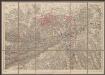
Solothurn - Basel - Brugg
1 : 100000 Kriegsdepot des Eidg. Topographischen Bureau's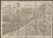
Solothurn - Basel - Brugg
1 : 100000 Kriegsdepot des Eidg. Topographischen Bureau's
Atlas der alten Eidgenossenschaft in 20 Karten: Kanton Basel
Originaltitel: Canton Basel sive Pagus Helvetiae Basileensis cum confinibus. Mit Erklärung der Zeichen. Zeichnung: Walser, Gabriel (1695-1776), reformierter Pfarrer, von Teufen AR Herausgeber: Homännische Erben
Trigonometisches Netz zur topographischen Karte des Cantons Aargau
1 : 125000 None
Canton Solothurn sive pagus Helvetiae Solodurensis cum confinibus
1 Karte : Kupferdruck ; 46 x 55 cm Walser Homann. Heredibus
Canton Solothurn sive pagus Helvetiae Solodurensis cum confinibus
1 Karte : Kupferdruck ; 46 x 55 cm Walser Homann. Heredibus
Canton Solothurn sive pagus Helvetiae Solodurensis cum confinibus
1 : 134500 Solothurn (Švýcarsko : kanton) Walser, Gabriel edentibus Homann. Heredib[us]
Der Canton Basel mit den angränzenden Bezirken
1 : 79000 Basilej-oblast (Švýcarsko) Diewald, Johann Nepomuk Bruckner bey Homanns Erben
Canton Solothurn Sive Pagus Helvetiae Solodurensis cum Confinibus recenter delineatus
1 : 110000 Mollova mapová sbírka Walser, Gabriel Homann, Johann Baptista - dědici
Lauf des Birs-Flusses von seinem Vrsprung an bis an seinen Ausfluss in den Rhein
1 Karte : Kupferdruck ; 27 x 14 cm Herrliberger; Büchel D. Herrliberger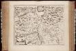
Territorivm Basileense, cum adjacentibus
1 : 140000 Annotatie: Verso UB VU-exemplaar is blanco; Origineel is Blad 115 in atlas factice; Annotatie geografische gegevens: Schaalstok linksonder; Zuid boven Joan Blaeu 1597/98-1673 [Amstelædami, labore & sumptibus : Ioannis Blaev]
Karte der Kantone Baselland und Baselstadt
1 : 100000 1 Karte von J.S. Gerster ; auf Anordnung der h. Erziehungsdirection von Baselland ; Zeichnung, Stich u. Druck von Wurster, Randegger & Cie. in Winterthur Wurster, Randegger & Cie., Winterthur

TERRITORIVM | BASILEENSE, | cum adjacentibus
[Amsterdam : Joan Blaeu]