Maps of Aargau
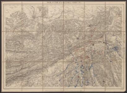
Solothurn - Basel - Brugg
1 : 100000 Kriegsdepot des Eidg. Topographischen Bureau's
Solothurn - Basel - Brugg
1 : 100000 Kriegsdepot des Eidg. Topographischen Bureau's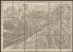
Solothurn - Basel - Brugg
1 : 100000 Kriegsdepot des Eidg. Topographischen Bureau's
Territory Basiliensis nova descriptio
1 Karte : Kupferdruck ; 34 x 47 cm Keere; Schenk; Valck penes Gerardum Valk et Petrum Schenk
Atlas novus Reipublicae Helveticae
1 Atlas ([40] Bl., 97 S.) bey Orell, Gessner und Compagnie, Zürich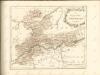
Topographische Karte der Schweiz (Dufour-Karte), Kartenzusammensetzungen: Den Kanton Zürich betreffende Blätter: Aarau
Eidgenössische Landestopographie, in Köniz-Wabern
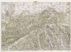
Kanton Aargau: Trigonometrisches Netz
1 : 125000 Ohne Datumsangabe.
Trigonometisches Netz zur topographischen Karte des Cantons Aargau
1 : 125000 None
Nivellements-Karte des Cantons Aargau
1 : 125000 Michaelis, Ernst Heinrich [Aargauische Militär-Kommission]
Die Cantone Solothurn und Basel
1 : 227700 Basilej-venkov (Švýcarsko : kanton) Scheurmenn, J. J.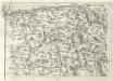
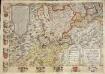
Geographica Provinciarum Sveviae Descriptio =
Mollova mapová sbírka Hurter, Johann Christoph Bodenehr, Johann Georg
Cantone Solothurn und Basel
1 : 275000 Scheuermann, Johann Jakob Orell, Füssli & Cp.
Atlas de la Suisse
1 : 450000 1 Atlas (19 Bl.) dessiné par MM. H. Keller, Scheurmann, Pfyffer d'Altishofen, Osterwald, etc. ; gravé par M. Scheurmann Orell Füssli & Co., Zürich
<<Der>> Canton Aargau
1 : 230000 1 Karte gez. u. gest. v. J.J. Scheurmann Orell, Füssli & Cp., Zürich
Der Canton Basel mit den angränzenden Bezirken
1 : 79000 Basilej-oblast (Švýcarsko) Diewald, Johann Nepomuk Bruckner bey Homanns Erben
<<Der>> Canton Aargau
1 : 230000 1 Karte gez. u. gest. v. J.J. Scheurmann Orell, Füssli & Cp., Zürich
Atlas der alten Eidgenossenschaft in 20 Karten: Kanton Basel
Originaltitel: Canton Basel sive Pagus Helvetiae Basileensis cum confinibus. Mit Erklärung der Zeichen. Zeichnung: Walser, Gabriel (1695-1776), reformierter Pfarrer, von Teufen AR Herausgeber: Homännische Erben
Schüler-Handkarte des Kantons Solothurn
1 : 200000 1 Karte von J.S. Gerster Hofer & Burger graph. Anst., Zürich
Carte von dem Canton Argau
1 Karte : Kupferdruck ; 42 x 48 cm Scheurmann zu haben bey J. Scheurmann Kupferstecher in Arau no. 252
Canton Solothurn sive pagus Helvetiae Solodurensis cum confinibus
1 Karte : Kupferdruck ; 46 x 55 cm Walser Homann. Heredibus
Canton Solothurn sive pagus Helvetiae Solodurensis cum confinibus
1 Karte : Kupferdruck ; 46 x 55 cm Walser Homann. Heredibus
Canton Solothurn sive pagus Helvetiae Solodurensis cum confinibus
1 Karte : Kupferdruck ; 23 x 25 cm Walser Homännische Erben
Carte von dem Canton Aargau
1 : 120000 Scheuermann, Johann Jakob Scheurmann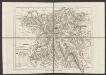
Canton Aargau
1 : 230000 Scheuermann, Johann Jakob Orell, Füssli & Cp.
Karte des Kantons Aargau
1 : 200000 1 Karte von J.S. Gerster Wurster, Randegger & Cie., Winterthur
Archäologische Karte des Kantons Solothurn
1 : 100000 Heierli, Jakob Petri
Geographica Provinciarum Sveviae Descriptio =
Mollova mapová sbírka Hurter, Johann Christoph Bodenehr, Gabriel
Karte der Kantone Baselland und Baselstadt
1 : 100000 1 Karte von J.S. Gerster ; auf Anordnung der h. Erziehungsdirection von Baselland ; Zeichnung, Stich u. Druck von Wurster, Randegger & Cie. in Winterthur Wurster, Randegger & Cie., Winterthur