Maps of Aargau

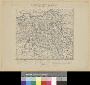
Karte des Kantons Aargau
1 : 250000 1 Karte J. Wurster & Comp., Winterthur
[Keller's Reisekarte der Schweiz]
1 : 500000 1 Karte auf 6 Bl. gezeichnet v. H. Keller ; gest. v. J.J. Scheurmann [Keller], Zürich
Reisekarte der Schweiz
1 : 500000 1 Atlas (1, 6 Bl.) gezeichnet von H. Keller und gestochen von J. Scheurmann = Carte routière de la Suisse / dessinée par H. Keller et gravée par J. Scheurmann bey Fuessli und Comp., Zürich
Per Inclyti Circuli Suevici Supremorum Ordinum :
1 : 160000 Mollova mapová sbírka Pfeffel, Johann Andreas Homann, Johann Baptista - dědici
Schulwandkarte zur Geschichte der Schweiz
1 : 180000 Nordblatt Oechsli, Wilhelm ; Baldamus, Alfred Kartograph. Verlagsanstalt von Georg Lang
<<Der>> Canton Aargau
1 : 230000 1 Karte gez. u. gest. v. J.J. Scheurmann [Orell Füssli & Cp.], [Zürich]
Zvrichgow et Basiliensis provincia
1 Karte : Kupferdruck ; 37 x 48 cm Janssonius; Broeck apud Johannem Janssonium
Zvrichgow et Basiliensis provincia
1 Karte : Kupferdruck ; 37 x 48 cm Valck; Schenk; Broeck apud G. Valk et P. Schenk
Zvrichgow et Basiliensis provincia
1 Karte : Kupferdruck ; 37 x 48 cm Blaeu Willem Janszoon Blaeu
Zvrichgow et Basiliensis provincia
1 Karte : Kupferdruck ; 36 x 48 cm Mercator; Blaeu s.n.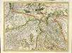
[Zurichgow, et Basiliensis provincia]
1 Karte : Kupferdruck ; 34 x 46 cm Mercator; Hondius Henricus Hondius
[Zurichgow, et Basiliensis provincia]
1 Karte : Kupferdruck ; 34 x 45 cm Mercator s.n.
Zürich 155, uit: [W. Liebenow's Special-Karte von Mittel-Europa]
1 : 300000 titelvariant: W. Liebenow's Mittel-Europa; Annotatie: Titel boven de bladen: W. Liebenow's Mittel-Europa Johannes Wilhelm Liebenow 1822-1897 Hannover : Hermann Oppermann
Atlas der Schweiz
1 : 450000 1 Atlas (18 Bl.) gez. u. gest. v. J. Scheurmann Orell Fussli, Zurich
Zurichgow et Basiliensis provincia [Karte], in: Le théâtre du monde, ou, Nouvel atlas contenant les chartes et descriptions de tous les païs de la terre, Bd. 1, S. 288.
1 Karte aus Atlas Blaeu, Willem Janszoon und Blaeu, Joan Blaeu, Willem Janszoon
Aargau
1 : 1450000 [Stumme Kartenskizzen der ganzen Schweiz und der einzelnen Kantone zu Unterrichtszwecken] Schulbuchhandlung Antenen
Atlas de la Suisse
1 : 450000 1 Atlas (19 Bl.) dessiné par MM. H. Keller, Scheurmann, Pfyffer d'Altishofen, Osterwald, etc. ; gravé par M. Scheurmann Orell Füssli & Co., Zürich
Zürich 155, uit: Special-Karte von Mittel-Europa / nach amtlichen Quellen bearbeitet von W. Liebenow
1 : 300000 titelvariant: W. Liebenow's Mittel-Europa; Annotatie: Titel boven de bladen: W. Liebenow's Mittel-Europa Johannes Wilhelm Liebenow 1822-1897 Frankfurt a. M. : Ludwig Ravenstein
ZVRICHGOW | et | Basiliensis provincia
[Amsterdam : Joan Blaeu]
Geographica Sueviæ universæ descriptio, 5
1 Blatt : Homännische Erben
Zurichgow et Basiliensis provincia
1 : 300000 1 Karte A. van den Broeck fecit apud G. Valk et P. Schenk, Amstelodami
<<Der>> Canton Aargau
1 : 230000 1 Karte gez. u. gest. von J.J. Scheurmann [Orell Füssli & Cp.], [Zürich]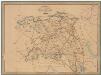
Kanton Aargau: Trigonometrisches Netz
Benz, Joh., Ingenieur
<<Der>> Canton Aargau
1 : 230000 1 Karte gez. u. gest. von J.J. Scheurmann Orell Füssli & Cp., Zürich
Kanton Aargau: Trigonometrisches Netz
1 : 125000 Ohne Datumsangabe.
Topographische Karte der Schweiz (Dufour-Karte): Den Kanton Zürich betreffende Blätter: Blatt VIII: Aarau, Luzern, Zug, Zürich
1 : 100000 Erstausgabe 1861; Nachführung 1866. Leitung: Dufour, Guillaume-Henri (1787-1875), General, Politiker, Ingenieur und Kartograf, von Genf; Eidgenössisches Topographisches Bureau, in Genf Stich: Müllhaupt, Heinrich (1820-1894), Kupferstecher und Kartograf, von Hofstetten; Stempelmann, J. (1835-1887) Druck: Koegel, Henri (1816-1867)
Taschen-Atlas der Schweiz
1 Atlas (25 S., 20 Taf.) gezeichnet und gestochen von Emil Wagner = Atlas de poche de la Suisse : 26 cartes en couleurs / dessinées et gravées par Émile Wagner Eggimann, Genf
Le canton de Zurich
1 Karte : Kupferdruck ; 14 x 18 cm s.n.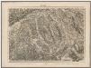
Topographische Karte der Schweiz (Dufour-Karte): Den Kanton Zürich betreffende Blätter: Blatt VIII: Aarau, Luzern, Zug, Zürich
1 : 100000 Erstausgabe 1861. Leitung: Dufour, Guillaume-Henri (1787-1875), General, Politiker, Ingenieur und Kartograf, von Genf; Eidgenössisches Topographisches Bureau, in Genf Stich: Müllhaupt, Heinrich (1820-1894), Kupferstecher und Kartograf, von Hofstetten; Stempelmann, J. (1835-1887) Druck: Koegel, Henri (1816-1867)