Maps of Péronne

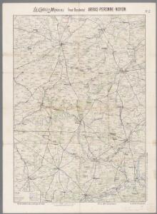
Arras, Peronne, Noyon, uit: Le conflict mondial : front occidental
1 : 170000 Annotatie: Ontbreekt: no. 1 en 5-8 Gand : Th. de Graeve
[20], uit: Hydro-Oro und Chorographische General Karte des Koenigreichs der Niederlande und der angrenzenden Länder bis Paris : mit der Angabe der Kunst und Heer-Strassen und der Entfernung der Poststationen / ... zusammengetragen und reducirt von ... Wilhelm Müller
1 : 400000 titelvariant: Generalkarte des Koenigreichs Hannover; Annotatie: 1e supplement bij: Generalkarte des Koenigreichs Hannover (1818) Müller, Wilhelm (fl. 1818) [Hannover : Wilhelm Müller]
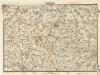
Partie Meridionale de Picardie
1 : 208000 Mollova mapová sbírka Delisle, Guillaume L'Isle, Guillaume de
Cambrai-Saint Quentin. Scale, 1 : 100,000 or 1 inch to 1.58 miles
Cambrai-Saint Quentin.
Veromandui
1 Karte : Kupferdruck ; 34 x 38 cm Sanson; Robert de Vaugondy; Cordier chés le Sr. Robert geog. du r. quai de l'Horloge
Carte particuliere des environs de Cambray, Bappaumes, St. Quentin, Perone
1 : 115000 A Amsterdam : chez Cóvens et Mortier
Carte particulière des environs de Cambray, Bappaumes, St. Quentin, Pérone
1 : 125000 A Bruxelles : ches Eugene Henry Fricx, ruë de la Madelene
Carte particuliere des environs de Cambray, Bappaumes, St. Quentin, Perone
1 : 110000 Bapaume (Francie) Fricx, Eugene Henry chez Eugene Henry Fricx
Carte particuliere des environs de Cambray, Bappaumes, S. Quentin, Perone
1 : 116600 Mollova mapová sbírka Fricx, Eugène Henry Harrewyn, Jacques Fricx, Eugené Henry
Veromanduorum Eorumque Confinium Exactissima Descriptio. [Karte], in: Theatrum orbis terrarum, S. 80.
1 Karte aus Atlas Ortelius, Abraham
Veromanduorum Eorumque Confinium Exactissima Descript. [Karte], in: Theatrum orbis terrarum, S. 137.
1 Karte aus Atlas Ortelius, Abraham Vrients, Jan Baptista
Vero Manduorum Eorum Que Confinium Exactissima Descriptio. [Karte], in: Theatrum orbis terrarum, S. 35.
1 Karte aus Atlas Ortelius, Abraham
Carte Particuliere des Environs de Cambray, Bappaumes, St. Quentin, Perone
1 : 250000 Mollova mapová sbírka Seutter, Matthäus Lotter, Tobias Conrad Seutter, Matthäus
[left] DESCRIPTIO | VEROMANDVORVM | [-] | Gallice | VERMANDOIS; [right] GOVVERNEMENT | de la | CAPPELLE
[left] Auctore Ioanne Surhonio; [right] par P. petit Bourbon Amsterdami | Apud Guiljelmum | et Joannem Blaeuw
Descriptio Veromanduorum [...] Gallice Vermandois. [Karte], in: Novus atlas absolutissimus, Bd. 4, S. 59.
1 Karte aus Atlas Janssonius Offizin
Carte Particuliere des Environs de Cambray, Bappaumes, St. Quentin, Perone
1 : 116600 Mollova mapová sbírka Fricx, Eugène Henry Covens, Johannes I
Descriptio Veromanduorum [Karte], in: Theatrum orbis terrarum, sive, Atlas novus, Bd. 2, S. 34.
1 Karte aus Atlas Blaeu, Joan Blaeu, Willem Janszoon
Vermandois [Karte], in: Gerardi Mercatoris et I. Hondii Newer Atlas, oder, Grosses Weltbuch, Bd. 2, S. 32.
1 Karte aus Atlas Mercator, Gerhard und Hondius, Jodocus Jansson, Jan
Descriptio Veromanduorum [...] Gallice Vermandois. [Karte], in: Novus Atlas, das ist, Weltbeschreibung, Bd. 2, S. 32.
1 Karte aus Atlas Blaeu, Joan Blaeu, Willem Janszoon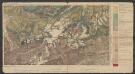
Descriptio Veromanduorum [...] Gallice Vermandois. [Karte], in: Le théâtre du monde, ou, Nouvel atlas contenant les chartes et descriptions de tous les païs de la terre, Bd. 2, S. 32.
1 Karte aus Atlas Blaeu, Willem Janszoon und Blaeu, Joan Blaeu, Willem Janszoon

Archiepiscopatus Cameracensis. Archebesché de Cambray. [Karte], in: Novus Atlas, das ist, Weltbeschreibung, Bd. 2, S. 26.
1 Karte aus Atlas Blaeu, Joan Blaeu, Willem Janszoon
Archiepiscopatus Cameracensis. Archevesché de Cambray. [Karte], in: Le théâtre du monde, ou, Nouvel atlas contenant les chartes et descriptions de tous les païs de la terre, Bd. 2, S. 26.
1 Karte aus Atlas Blaeu, Willem Janszoon und Blaeu, Joan Blaeu, Willem Janszoon
Arcihiepiscopatus Cameracensis. Archevesche de Cambray. [Karte], in: Novus atlas absolutissimus, Bd. 3, S. 150.
1 Karte aus Atlas Janssonius Offizin
L'Archevesche de Cambray [Karte], in: Gerardi Mercatoris et I. Hondii Newer Atlas, oder, Grosses Weltbuch, Bd. 2, S. 26.
1 Karte aus Atlas Mercator, Gerhard und Hondius, Jodocus Jansson, Jan
Archiepiscopatus Cameracensis. Archevesché de Cambray. [Karte], in: Theatrum orbis terrarum, sive, Atlas novus, Bd. 2, S. 41.
1 Karte aus Atlas Blaeu, Joan Blaeu, Willem Janszoon
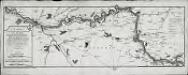
Carte d'une partie de la riviere de Somme
1 Karte : Kupferdruck ; 23 x 68 cm Dezauche chez Dezauche successeur des S.rs Delisle et Buache rue des Noyers
ARCHIEPISCOPATVS | CAMERACENSIS. | Archevesché de | CAMBRAY
AMSTERDAMI | Apud Guiljelmum Blaeuw