Maps of Péronne

Carte particuliere des environs de Cambray, Bappaumes, S. Quentin, Perone
1 : 116600 Mollova mapová sbírka Fricx, Eugène Henry Harrewyn, Jacques Fricx, Eugené Henry
Carte particuliere des environs de Cambray, Bappaumes, St. Quentin, Perone
1 : 110000 Bapaume (Francie) Fricx, Eugene Henry chez Eugene Henry Fricx
Carte particuliere des environs de Cambray, Bappaumes, St. Quentin, Perone
1 : 115000 A Amsterdam : chez Cóvens et Mortier
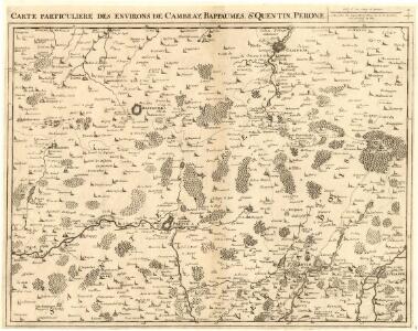
Carte particulière des environs de Cambray, Bappaumes, St. Quentin, Pérone
1 : 125000 A Bruxelles : ches Eugene Henry Fricx, ruë de la Madelene
Carte Particuliere des Environs de Cambray, Bappaumes, St. Quentin, Perone
1 : 250000 Mollova mapová sbírka Seutter, Matthäus Lotter, Tobias Conrad Seutter, Matthäus
Carte Particuliere des Environs de Cambray, Bappaumes, St. Quentin, Perone
1 : 116600 Mollova mapová sbírka Fricx, Eugène Henry Covens, Johannes I
Cambrai-Saint Quentin. Scale, 1 : 100,000 or 1 inch to 1.58 miles
Cambrai-Saint Quentin.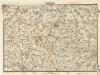
Cambrai

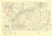
Battle of the Somme: August 1916
1 : 80000 Battle of the Somme. Situation in August, 1916. War Office
Battle of the Somme: July 1916
1 : 80000 Battle of the Somme. Situation in July 1916. War Office
Somme Front 1916: Allied lines in Sept. and Oct.
1 : 40000 First World War map of the Somme Front. Allied lines in Sept. and Oct. 1916. War Office
Somme Front 1916: Allied lines in Oct. and Nov.
1 : 40000 First World War map of the Somme Front. Allied lines in Oct. and Nov. 1916. War Office
Das Kampfgebiet an der Somme
1 : 200000 Somme, řeka (Francie) Velhagen & Klasing
Map of the Somme area.
1 : 40000 First World War map showing progress in Arras area. December 1916. War Office
Map of the Somme area. Dec. 1916.
1 : 40000 First World War map of the Somme area. Dec.1916. Same map with Japanse characters at Maps 17535(3) and Russian at Maps 17535(4). War Office
Map of the Somme Front.
1 : 40000 First World War map of the Somme Front. Advances between July 1st 1916 and 28th Feb 1917. War Office
Archiepiscopatvs Cameracensis
1 : 200000 Mollova mapová sbírka Blaeu, Willem Janszoon Blaeu, Willem Jansz.
Carte du gouuernement de Bappaume
1 Karte : Kupferdruck ; 11 x 15 cm s.n.
Cambrai. Scale, 1 : 40,000
Cambrai. Scale, 1 : 40,000. [London] : [Geographical Section, General Staff], November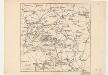
Map showing front lines around Bapaume, France, in 1916 Fron Line 1916
1 : 885000 Fron Line 1916 H. & C. Graham Ltd. Lithrs. London : Stanford's Geogl. Estabt.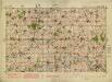
Albert. Scale, 1: 40,000. First edition
Albert. Scale, 1: 40,000. First edition. [London] : [Geographical Section, General Staff]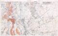
Defence of Hindenburg line no.1
1 : 20000 First World War map of defence of Hindenburg line. German artillery positions. From captured German maps dated 10-2-17. Sheet titled Joncourt. Parts of 62c NE and 62b NW. War Office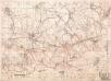
Enemy organisation 6-9-17. Nauroy 2nd ed.
1 : 20000 First World War map. Enemy organisation 6-9-17. Nauroy 2nd ed. Special sheet. War Office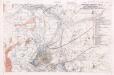
Defence of Hindenburg line no.2
1 : 20000 First World War map of defence of Hindenburg line. German artillery positions. From captured German maps dated 10-2-17. Sheet 62b SW. War Office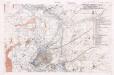
Defence of Hindenburg line no.5
1 : 20000 First World War map of defence of Hindenburg line. German artillery positions. From captured German maps dated 10-2-17. Sheet 62b SW. War Office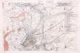
Defence of Hindenburg line no.3
1 : 20000 First World War map of defence of Hindenburg line. German artillery positions. From captured German maps dated 10-2-17. Sheet 62b SW. War Office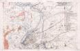
Defence of Hindenburg line no.4
1 : 20000 First World War map of defence of Hindenburg line. German artillery positions. From captured German maps dated 10-2-17. Sheet 62b SW. War Office
S. Qvintin belaegert
Saint-Quentin (Francie)
Sailly Saillisel
Sailly Saillisel. Scale, 1 : 20,000. [London] : [Geographical Section, General Staff]