Maps of Saint-Quentin

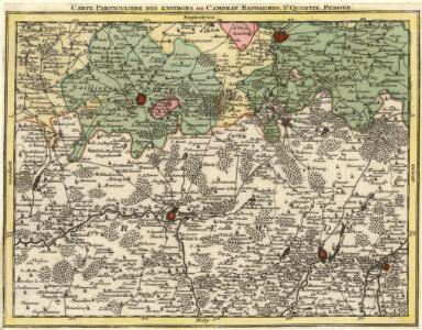
Carte Particuliere des Environs de Cambray, Bappaumes, St. Quentin, Perone
1 : 250000 Mollova mapová sbírka Seutter, Matthäus Lotter, Tobias Conrad Seutter, Matthäus
Carte particuliere des environs de Cambray, Bappaumes, St. Quentin, Perone
1 : 110000 Bapaume (Francie) Fricx, Eugene Henry chez Eugene Henry Fricx
Carte particuliere des environs de Cambray, Bappaumes, St. Quentin, Perone
1 : 115000 A Amsterdam : chez Cóvens et Mortier
Carte particuliere des environs de Cambray, Bappaumes, S. Quentin, Perone
1 : 116600 Mollova mapová sbírka Fricx, Eugène Henry Harrewyn, Jacques Fricx, Eugené Henry
Carte particulière des environs de Cambray, Bappaumes, St. Quentin, Pérone
1 : 125000 A Bruxelles : ches Eugene Henry Fricx, ruë de la Madelene
Carte Particuliere des Environs de Cambray, Bappaumes, St. Quentin, Perone
1 : 116600 Mollova mapová sbírka Fricx, Eugène Henry Covens, Johannes I
Cambrai

Archiepiscopatvs Cameracensis
1 : 200000 Mollova mapová sbírka Blaeu, Willem Janszoon Blaeu, Willem Jansz.
Somme Front 1916: Allied lines in Sept. and Oct.
1 : 40000 First World War map of the Somme Front. Allied lines in Sept. and Oct. 1916. War Office
Cambrai. Scale, 1 : 40,000
Cambrai. Scale, 1 : 40,000. [London] : [Geographical Section, General Staff], November
Somme Front 1916: Allied lines in Oct. and Nov.
1 : 40000 First World War map of the Somme Front. Allied lines in Oct. and Nov. 1916. War Office
Battle of the Somme: August 1916
1 : 80000 Battle of the Somme. Situation in August, 1916. War Office
Battle of the Somme: July 1916
1 : 80000 Battle of the Somme. Situation in July 1916. War Office
Map of the Somme area.
1 : 40000 First World War map showing progress in Arras area. December 1916. War Office
Map of the Somme area. Dec. 1916.
1 : 40000 First World War map of the Somme area. Dec.1916. Same map with Japanse characters at Maps 17535(3) and Russian at Maps 17535(4). War Office
Carte du gouuernement de Bappaume
1 Karte : Kupferdruck ; 11 x 15 cm s.n.
Defence of Hindenburg line no.1
1 : 20000 First World War map of defence of Hindenburg line. German artillery positions. From captured German maps dated 10-2-17. Sheet titled Joncourt. Parts of 62c NE and 62b NW. War Office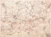
Enemy organisation 6-9-17. Nauroy 2nd ed.
1 : 20000 First World War map. Enemy organisation 6-9-17. Nauroy 2nd ed. Special sheet. War Office
Map of the Somme Front.
1 : 40000 First World War map of the Somme Front. Advances between July 1st 1916 and 28th Feb 1917. War Office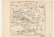
Map showing front lines around Bapaume, France, in 1916 Fron Line 1916
1 : 885000 Fron Line 1916 H. & C. Graham Ltd. Lithrs. London : Stanford's Geogl. Estabt.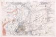
Defence of Hindenburg line no.2
1 : 20000 First World War map of defence of Hindenburg line. German artillery positions. From captured German maps dated 10-2-17. Sheet 62b SW. War Office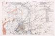
Defence of Hindenburg line no.5
1 : 20000 First World War map of defence of Hindenburg line. German artillery positions. From captured German maps dated 10-2-17. Sheet 62b SW. War Office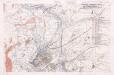
Defence of Hindenburg line no.3
1 : 20000 First World War map of defence of Hindenburg line. German artillery positions. From captured German maps dated 10-2-17. Sheet 62b SW. War Office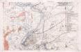
Defence of Hindenburg line no.4
1 : 20000 First World War map of defence of Hindenburg line. German artillery positions. From captured German maps dated 10-2-17. Sheet 62b SW. War Office
S. Qvintin belaegert
Saint-Quentin (Francie)
Sailly Saillisel
Sailly Saillisel. Scale, 1 : 20,000. [London] : [Geographical Section, General Staff]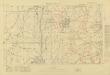
Trench Maps of the Battle Front in France and Belgium, Villers-Guislan
Trench Maps [of the Battle Front in France and Belgium, showing trenches, wire entanglement, etc. With a Glossary printed on the back of the sheets]. Scale, 1: 10,000.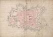
A colored plan of the town and citadel of Cambray;
A colored manuscript plan of the town and citadel of Cambray, France; drawn [in 1692?] without a scale, but about 50 toises to an inch.
A colored plan of the town and citadel of Cambray
A colored manuscript plan of the town and citadel of Cambray, France; drawn in November, 1711, on a scale of 62 1/2 toises to an inch.