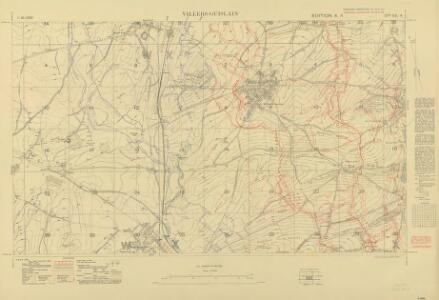
Maps of Villers-Guislain
Trench Maps of the Battle Front in France and Belgium, Villers-Guislan
Trench Maps [of the Battle Front in France and Belgium, showing trenches, wire entanglement, etc. With a Glossary printed on the back of the sheets]. Scale, 1: 10,000.
Cambrai. Scale, 1 : 40,000
Cambrai. Scale, 1 : 40,000. [London] : [Geographical Section, General Staff], November
Archiepiscopatvs Cameracensis
1 : 200000 Mollova mapová sbírka Blaeu, Willem Janszoon Blaeu, Willem Jansz.
Carte Particuliere des Environs de Cambray, Bappaumes, St. Quentin, Perone
1 : 116600 Mollova mapová sbírka Fricx, Eugène Henry Covens, Johannes I
Carte Particuliere des Environs de Cambray, Bappaumes, St. Quentin, Perone
1 : 250000 Mollova mapová sbírka Seutter, Matthäus Lotter, Tobias Conrad Seutter, Matthäus
Cambrai

Carte particuliere des environs de Cambray, Bappaumes, S. Quentin, Perone
1 : 116600 Mollova mapová sbírka Fricx, Eugène Henry Harrewyn, Jacques Fricx, Eugené Henry
Carte particuliere des environs de Cambray, Bappaumes, St. Quentin, Perone
1 : 110000 Bapaume (Francie) Fricx, Eugene Henry chez Eugene Henry Fricx
Archiepiscopatvs Cameracensis
1 Karte : Kupferdruck ; 37 x 48 cm Blaeu apud Guiljelmum Blaeuw
L'archevesche de Cambray
1 Karte : Kupferdruck ; 35 x 48 cm Tavernier; Hondius imprimé ches Henrÿ Hondius, ches Melchior Tavernier aupres du palais
Veromandvorvm eorvm qve confinivm exactissima descriptio
1 Karte : Kupferdruck ; 34 x 21 cm Ortelius; Surhon; Surhon s.n.
Veromandvorvm eorvm qve confinivm exactissima descriptio
1 Karte : Kupferdruck ; 34 x 21 cm Ortelius; Surhon; Surhon s.n.

Carte particuliere des environs de Cambray, Bappaumes, St. Quentin, Perone
1 : 115000 A Amsterdam : chez Cóvens et Mortier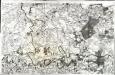
[Cambray]
1 Blatt : 60 x 91 cm Seguin; Desbruslins s.n.
Carte particulière des environs de Cambray, Bappaumes, St. Quentin, Pérone
1 : 125000 A Bruxelles : ches Eugene Henry Fricx, ruë de la Madelene
Cambrai-Saint Quentin. Scale, 1 : 100,000 or 1 inch to 1.58 miles
Cambrai-Saint Quentin.
Arcihiepiscopatus Cameracensis ; Archevesche de Cambray
1 : 59000
[left] DESCRIPTIO | VEROMANDVORVM | [-] | Gallice | VERMANDOIS; [right] GOVVERNEMENT | de la | CAPPELLE
[left] Auctore Ioanne Surhonio; [right] par P. petit Bourbon Amsterdami | Apud Guiljelmum | et Joannem Blaeuw
Descriptio Veromanduorum [Karte], in: Theatrum orbis terrarum, sive, Atlas novus, Bd. 2, S. 34.
1 Karte aus Atlas Blaeu, Joan Blaeu, Willem Janszoon
Descriptio Veromanduorum [...] Gallice Vermandois. [Karte], in: Novus Atlas, das ist, Weltbeschreibung, Bd. 2, S. 32.
1 Karte aus Atlas Blaeu, Joan Blaeu, Willem Janszoon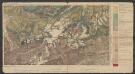
Descriptio Veromanduorum [...] Gallice Vermandois. [Karte], in: Le théâtre du monde, ou, Nouvel atlas contenant les chartes et descriptions de tous les païs de la terre, Bd. 2, S. 32.
1 Karte aus Atlas Blaeu, Willem Janszoon und Blaeu, Joan Blaeu, Willem Janszoon
ARCHIEPISCOPATVS | CAMERACENSIS. | Archevesché de | CAMBRAY
AMSTERDAMI | Apud Guiljelmum Blaeuw
Descriptio Veromanduorum [...] Gallice Vermandois. [Karte], in: Novus atlas absolutissimus, Bd. 4, S. 59.
1 Karte aus Atlas Janssonius Offizin
Archiepiscopatus Cameracensis. Archevesché de Cambray. [Karte], in: Theatrum orbis terrarum, sive, Atlas novus, Bd. 2, S. 41.
1 Karte aus Atlas Blaeu, Joan Blaeu, Willem Janszoon
Vermandois [Karte], in: Gerardi Mercatoris et I. Hondii Newer Atlas, oder, Grosses Weltbuch, Bd. 2, S. 32.
1 Karte aus Atlas Mercator, Gerhard und Hondius, Jodocus Jansson, Jan
Vero Manduorum Eorum Que Confinium Exactissima Descriptio. [Karte], in: Theatrum orbis terrarum, S. 35.
1 Karte aus Atlas Ortelius, Abraham
Arcihiepiscopatus Cameracensis. Archevesche de Cambray. [Karte], in: Novus atlas absolutissimus, Bd. 3, S. 150.
1 Karte aus Atlas Janssonius Offizin
L'Archevesche de Cambray [Karte], in: Gerardi Mercatoris et I. Hondii Newer Atlas, oder, Grosses Weltbuch, Bd. 2, S. 26.
1 Karte aus Atlas Mercator, Gerhard und Hondius, Jodocus Jansson, Jan