Maps of Cambrai

Archiepiscopatvs Cameracensis
1 : 200000 Mollova mapová sbírka Blaeu, Willem Janszoon Blaeu, Willem Jansz.
Archiepiscopatvs Cameracensis
1 Karte : Kupferdruck ; 37 x 48 cm Blaeu apud Guiljelmum Blaeuw
L'archevesche de Cambray
1 Karte : Kupferdruck ; 35 x 48 cm Tavernier; Hondius imprimé ches Henrÿ Hondius, ches Melchior Tavernier aupres du palais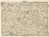
Cambrai
Cambrai. Scale, 1 : 40,000
Cambrai. Scale, 1 : 40,000. [London] : [Geographical Section, General Staff], November
Namur. Haynaut et Cambresis
Mollova mapová sbírka Aa, Pieter van der Aa, Janson Vander
Carte du gouuernement de Bappaume
1 Karte : Kupferdruck ; 11 x 15 cm s.n.
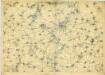
Map showing progress in Arras area
1 : 40000 First World War map showing progress in Arras area. War Office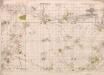
Positions Map 3-12-17. Sauchy-Cauchy.
1 : 20000 First World War map. Positions Map 3-12-17. Sauchy-Cauchy. War Office
Sailly Saillisel
Sailly Saillisel. Scale, 1 : 20,000. [London] : [Geographical Section, General Staff]
Plan of the city Bouchain sitoated upon the rivers sensette and Scheld in the Country of Hainaut
Tindal; Rapin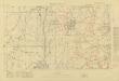
Trench Maps of the Battle Front in France and Belgium, Villers-Guislan
Trench Maps [of the Battle Front in France and Belgium, showing trenches, wire entanglement, etc. With a Glossary printed on the back of the sheets]. Scale, 1: 10,000.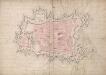
A colored plan of the town and citadel of Cambray;
A colored manuscript plan of the town and citadel of Cambray, France; drawn [in 1692?] without a scale, but about 50 toises to an inch.
A colored plan of the town and citadel of Cambray
A colored manuscript plan of the town and citadel of Cambray, France; drawn in November, 1711, on a scale of 62 1/2 toises to an inch.
Plan de la ville et citadelle de Cambray: place forte du pays bas capitalle du Comté Cambresis situé sur la riviere de l'Escaut a trois lieues de Bouchain, a cinq du Quesnoy, a six et demy de Landrecy, a six de Valenciene, a cinq de Douay, a huit [...]
1 : 5000 B. v. Zyl fecit
CAMERACUM, | Vulgo CAMBRAY
[Amsterdam : Joan Blaeu]
Plan de l'Entreprise françoise contre le Camp Retrenche à Denain
1 : 35000 Mollova mapová sbírka Visscher, Elisabeth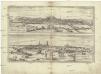
Montes, Hannoniae metropolis
Arras (Francie) Braun, Georg Hogenberg, Franz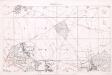
Map No. 9. Thielt. Town plan
1 : 5000 Details houses occupied by German officers, etc. 'Casino usually filled with German officers'. War Office
Plan de l'entreprise et de l'attacque de l'armée Francoise commandée par le mar.l De Villars sur le camp retranchée a Denain commandée par mylord Albemarle le 24 Juillet 1712
1 : 25000 B.V. Zijl fecit A La Haye : chez Pierre Husson
Disegno della citta d'Arras e suo territorio
1 : 53300 Arras (Francie)
ATREBATVM, | Gallis ARRAS, | Belgis ATRECHT dicta
[Amsterdam : Joan Blaeu]
[Arras et environs]
1 : 20000 Annotatie: Herdruk van originele koperplaat; Oorspr. uitg.: ca. 1850 [Paris : I.G.N.]
Arcihiepiscopatus Cameracensis ; Archevesche de Cambray
1 : 59000
ARCHIEPISCOPATVS | CAMERACENSIS. | Archevesché de | CAMBRAY
AMSTERDAMI | Apud Guiljelmum Blaeuw
Archiepiscopatus Cameracensis. Archevesché de Cambray. [Karte], in: Theatrum orbis terrarum, sive, Atlas novus, Bd. 2, S. 41.
1 Karte aus Atlas Blaeu, Joan Blaeu, Willem Janszoon
Arcihiepiscopatus Cameracensis. Archevesche de Cambray. [Karte], in: Novus atlas absolutissimus, Bd. 3, S. 150.
1 Karte aus Atlas Janssonius Offizin
L'Archevesche de Cambray [Karte], in: Gerardi Mercatoris et I. Hondii Newer Atlas, oder, Grosses Weltbuch, Bd. 2, S. 26.
1 Karte aus Atlas Mercator, Gerhard und Hondius, Jodocus Jansson, Jan


