Maps of Saint-Quentin

Vero Manduorum Eorum Que Confinium Exactissima Descriptio. [Karte], in: Theatrum orbis terrarum, S. 35.
1 Karte aus Atlas Ortelius, Abraham
Veromanduorum Eorumque Confinium Exactissima Descriptio. [Karte], in: Theatrum orbis terrarum, S. 80.
1 Karte aus Atlas Ortelius, Abraham
Veromanduorum Eorumque Confinium Exactissima Descript. [Karte], in: Theatrum orbis terrarum, S. 137.
1 Karte aus Atlas Ortelius, Abraham Vrients, Jan Baptista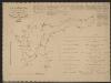
Vermandois [Karte], in: Gerardi Mercatoris et I. Hondii Newer Atlas, oder, Grosses Weltbuch, Bd. 2, S. 32.
1 Karte aus Atlas Mercator, Gerhard und Hondius, Jodocus Jansson, Jan
Descriptio Veromanduorum [...] Gallice Vermandois. [Karte], in: Novus atlas absolutissimus, Bd. 4, S. 59.
1 Karte aus Atlas Janssonius Offizin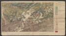
Descriptio Veromanduorum [...] Gallice Vermandois. [Karte], in: Le théâtre du monde, ou, Nouvel atlas contenant les chartes et descriptions de tous les païs de la terre, Bd. 2, S. 32.
1 Karte aus Atlas Blaeu, Willem Janszoon und Blaeu, Joan Blaeu, Willem Janszoon
Descriptio Veromanduorum [...] Gallice Vermandois. [Karte], in: Novus Atlas, das ist, Weltbeschreibung, Bd. 2, S. 32.
1 Karte aus Atlas Blaeu, Joan Blaeu, Willem Janszoon
Descriptio Veromanduorum [Karte], in: Theatrum orbis terrarum, sive, Atlas novus, Bd. 2, S. 34.
1 Karte aus Atlas Blaeu, Joan Blaeu, Willem Janszoon
[left] DESCRIPTIO | VEROMANDVORVM | [-] | Gallice | VERMANDOIS; [right] GOVVERNEMENT | de la | CAPPELLE
[left] Auctore Ioanne Surhonio; [right] par P. petit Bourbon Amsterdami | Apud Guiljelmum | et Joannem Blaeuw

Veromandvorvm eorvm qve confinivm exactissima descriptio
1 Karte : Kupferdruck ; 34 x 21 cm Ortelius; Surhon; Surhon s.n.
Veromandvorvm eorvm qve confinivm exactissima descriptio
1 Karte : Kupferdruck ; 34 x 21 cm Ortelius; Surhon; Surhon s.n.
Map of water supply: St Quentin and part of Amiens
1 : 100000 Series of maps on water supplies. St Quentin and part of Amiens. War Office
Veromandui
1 Karte : Kupferdruck ; 34 x 38 cm Sanson; Robert de Vaugondy; Cordier chés le Sr. Robert geog. du r. quai de l'Horloge
Descriptio Veromandvorvm
2 Karten auf 1 Blatt : Kupferdruck ; je 38 x 25 cm Janssonius; Surhon; Surhon; Petit Joannes Janssonius
Descriptio Veromandvorvm
2 Karten auf 1 Blatt : Kupferdruck ; je 38 x 25 cm Valck; Schenk; Surhon; Surhon; Petit apud G. Valk et P. Schenk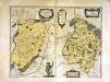
Descriptio Veromandvorvm
2 Karten auf 1 Blatt : Kupferdruck ; je 38 x 25 cm Blaeu; Blaeu; Surhon; Surhon; Petit apud Guiljelmum et Joannem Blaeuw
Carte Particuliere des Environs de Cambray, Bappaumes, St. Quentin, Perone
1 : 250000 Mollova mapová sbírka Seutter, Matthäus Lotter, Tobias Conrad Seutter, Matthäus
Carte particulière des environs de Cambray, Bappaumes, St. Quentin, Pérone
1 : 125000 A Bruxelles : ches Eugene Henry Fricx, ruë de la Madelene
Carte particuliere des environs de Cambray, Bappaumes, St. Quentin, Perone
1 : 115000 A Amsterdam : chez Cóvens et Mortier
Vermandois
1 Karte : Kupferdruck ; 35 x 48 cm Tavernier; Hondius imprime chez Henry Hondius demeurant sur le Dam a l'enseigne du grand atlas, chez Melchior Tavernier demeurant sur l'isle du Palais a la sphere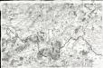
[Laon - Noyon]
1 Blatt : 60 x 91 cm s.n.
Carte particuliere des environs de Cambray, Bappaumes, St. Quentin, Perone
1 : 110000 Bapaume (Francie) Fricx, Eugene Henry chez Eugene Henry Fricx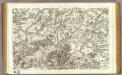
43 Laon, Noyon.
1 : 86400 Cassini family; Cassini, Cesar-Francois, 1714-1784
Map of water supply: St Quentin
1 : 100000 Series of maps on water supplies. St Quentin. War Office
Carte particuliere des environs de Cambray, Bappaumes, S. Quentin, Perone
1 : 116600 Mollova mapová sbírka Fricx, Eugène Henry Harrewyn, Jacques Fricx, Eugené Henry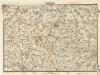
Cambrai

Carte Particuliere des Environs de Cambray, Bappaumes, St. Quentin, Perone
1 : 116600 Mollova mapová sbírka Fricx, Eugène Henry Covens, Johannes I
Cambrai-Saint Quentin. Scale, 1 : 100,000 or 1 inch to 1.58 miles
Cambrai-Saint Quentin.
![Vero Manduorum Eorum Que Confinium Exactissima Descriptio. [Karte], in: Theatrum orbis terrarum, S. 35.](https://images-2.georeferencer.com/images/iiif/134985232434/full/,300/0/native.jpg)

